- Marshland St James
-
Coordinates: 52°39′25″N 0°14′26″E / 52.656915°N 0.240498°E
Marshland St James 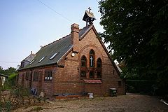
Former church in Marshland St James
 Marshland St James
Marshland St James shown within NorfolkArea 25.69 km2 (9.92 sq mi) Population 1,137 - Density 44 /km2 (110 /sq mi) OS grid reference TF516089 Parish Marshland St James District King's Lynn and West Norfolk Shire county Norfolk Region East Country England Sovereign state United Kingdom Post town WISBECH Postcode district PE14 Police Norfolk Fire Norfolk Ambulance East of England EU Parliament East of England List of places: UK • England • Norfolk Marshland St James is a civil parish in the English county of Norfolk. It covers an area of 25.69 km2 (9.92 sq mi) and had a population of 1,137 in 456 households as of the 2001 census.[1] For the purposes of local government, it falls within the district of King's Lynn and West Norfolk.
Notes
- ^ Census population and household counts for unparished urban areas and all parishes. Office for National Statistics & Norfolk County Council (2001). Retrieved 20 June 2009.
External links
 Media related to Marshland St James at Wikimedia CommonsCategories:
- King's Lynn and West Norfolk
- Villages in Norfolk
- Civil parishes in Norfolk
- Norfolk geography stubs


Wikimedia Foundation. 2010.