- Mission, Calgary
-
For other uses, see Mission.
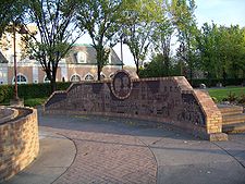
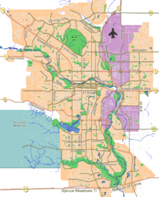
Mission — Neighbourhood — Rouleauville Square in the Mission district Location of Mission in Calgary Coordinates: 51°01′55″N 114°04′12″W / 51.03194°N 114.07°W Country  Canada
Province  Alberta
City  Calgary
Quadrant SW Ward 8 Established 1900 Annexed 1906 Government[1] – Administrative body Calgary City Council – Alderman John Mar Area – Total 0.4 km2 (0.2 sq mi) Elevation 1,050 m (3,445 ft) Population (2006)[2] – Total 4,433 – Average Income $37,040 Website Mission Community Association The Mission district is an inner city neighbourhood of Calgary, Alberta, Canada that originated as Notre Dame de la Paix, a Catholic mission, and was for a time the incorporated Village of Rouleauville. Mission contains the very popular 4th Street with many trendy restaurants and shops, and it hosts the Lilac Festival in May.
It is represented in the Calgary City Council by Ward 8 Alderman John Mar.[3] The community has an area redevelopment plan in place.[4]
Contents
History
After a temporary location 40 km (25 mi) away (started in 1872), Oblate missionary Father Constantine Scollen, on behalf of the Roman Catholic Church, founded the permanent location in 1875. In 1883, Oblate missionary Father Albert Lacombe, returning after a ten year absence, obtained two quarter sections of land for a "Mission district" to ensure a strong French speaking Catholic community. Father Scollen who had lived in the area since 1862 and who had witnessed Treaty Six with the Cree Nation and Treaty Seven with the Blackfeet Nation left for Edmonton and then the U.S.A.
After obtaining the rest of the land that's now Mission, the area was incorporated on November 2, 1899 as the Village of Rouleauville named after Charles Rouleau. The village was founded in what was then the Northwest Territories.[5] Despite Lacombe's desire to preserve the French language and culture, Rouleauville progressively lost its French character, becoming overwhelmingly English. In 1907 the village was annexed by Calgary. In the process all the French names of streets were replaced by Calgary's street numbering system. [6]
Institutions
In the latter part of his life, Lacombe helped found a number of Catholic schools throughout the West, including St. Mary's School in 1885, initially using a two-storey log cabin convent in Mission district (Rouleauville). It is now the oldest school still operating in Calgary (though in a newer building). Talisman Centre is also located in this neighborhood.
In 1889 St. Mary's Church was founded, and in 1912 it became St. Mary's Cathedral when it became the seat of the newly formed Diocese of Calgary.
Demographics
In 2006 the neighbourhood had a population of 4,433.[7] Residents in this community had a median household income of $37,040 in 2000, and there were 25% low income residents living in the neighbourhood.[1] As of 2000, 20.1% of the residents were immigrants. A proportion of 94.6% of the buildings were condominiums or apartments, and 70% of the housing was used for renting.[2]
References
- ^ a b City of Calgary (2004). "Ward 8 Profile". http://www.calgary.ca/docgallery/bu/cns/community_social_statistics/ward_8_profile.pdf. Retrieved 2007-05-09.
- ^ a b City of Calgary (2006). "Mission Community Statistics". http://www.calgary.ca/docgallery/bu/cns/community_social_statistics/mission.pdf. Retrieved 2007-05-09.
- ^ Federation of Calgary Communities. "Cliff Bungalow-Mission Community". http://www.calgaryarea.com/sw/cliffbung/cliffbung.htm. Retrieved 2007-05-09.
- ^ City of Calgary Planning (2005). "Mission Area Redevelopment Plan". http://www.calgary.ca/portal/server.pt/gateway/PTARGS_0_2_784_203_0_43/http%3B/content.calgary.ca/CCA/City+Living/Communities/Development+Plans+and+Projects/Mission+Area+Redevelopment+Plan.htm. Retrieved 2007-05-09.[dead link]
- ^ Rouleauville at Glenbow Museum - Information on the history of the French speaking village.
- ^ Rouleauville at Alberta Heritage - Discusses Father Lacombe and the village
- ^ City of Calgary (2006). "Community Population Comparison". http://www.calgary.ca/DocGallery/BU/cityclerks/popcomparisonbycomm.pdf. Retrieved 2007-05-09.
External links

Beltline (Connaught) Beltline (Midtown) Beltline (Victoria Park) 
Cliff Bungalow 
Talisman Centre  Mission

Mount Royal Roxboro Elbow River
ErltonCoordinates: 51°02′00.2″N 114°04′17.3″W / 51.033389°N 114.071472°W
Categories:- Neighbourhoods in Calgary
Wikimedia Foundation. 2010.


