- Mount Elbrus
-
For other uses, see Elbruz (disambiguation).
Mount Elbrus 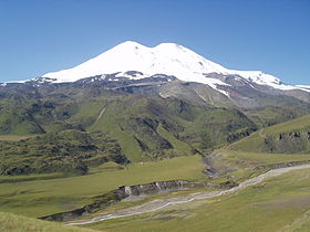
Mount ElbrusElevation 5,642 m (18,510 ft) [1] Prominence 4,741 m (15,554 ft) Ranked 10th Listing Seven Summits
Volcanic Seven Summits
Country high point
UltraLocation Location of Mount Elbrus within the Caucasus mountains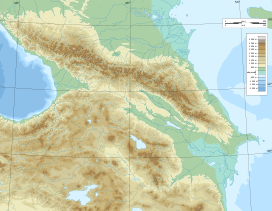
 Mount Elbrus
Location Russia, on the border of Asia and Europe Range Caucasus Coordinates 43°21′18″N 42°26′21″E / 43.355°N 42.43917°ECoordinates: 43°21′18″N 42°26′21″E / 43.355°N 42.43917°E Topo map Elbrus and Upper Baksan Valley by EWP[2][3] Geology Type Stratovolcano (dormant) Age of rock Unknown Last eruption 50 CE ± 50 years[4] Climbing First ascent (west summit) 1874, by Florence Crauford Grove, Frederick Gardner, Horace Walker, Peter Knubel and guide Ahiya Sottaiev
(lower summit) 22 July 1829 by Khillar KhachirovEasiest route basic snow/ice climb  Elbrus 3D
Mount Elbrus (Russian: Эльбрус, Elbrus; Karachay-Balkar: Минги тау, Miñi taw, pronounced [miŋŋi taw] (
 listen)) is an inactive volcano located in the western Caucasus mountain range, in Kabardino-Balkaria and Karachay-Cherkessia, Russia, near the border of Georgia. Mt. Elbrus's peak is the highest in the Caucasus, in Russia. While there are differing authorities on how the Caucasus are distributed between Europe and Asia, many sources agree that Elbrus is also the highest mountain in all of Europe.[5] Mt. Elbrus (west summit) stands at 5,642 metres (18,510 ft); the east summit is slightly lower at 5,621 metres (18,442 ft).
Contents
Etymology
The name Elbrus (English pronunciation: /ˈɛlbrəs/) is a metathesis of Alborz.[6] The name Alborz is derived from that of Harā Bərəzaitī, a legendary mountain in Persian mythology.[6] Harā Bərəzaitī reflects Proto-Iranian *Harā Bṛzatī. *Bṛzatī is the feminine form of the adjective *bṛzant—"high", the reconstructed ancestor of modern Persian boland (بلند) and Barz/Berazandeh.[6] Harā may be interpreted as "watch" or "guard", from an Indo-European root *ser—"protect".[6] In Middle Persian, Harā Bərəzaitī became Harborz, Modern Persian Alborz, which is cognate with Elbrus.[6]
Other names
- Uashhemafe (Iуашъхьэмафэ) – the mount of happiness, or the blessed mountain (Circassian)
- Mingi Taw (Минги-Тау) – a Karachay–Balkar (Turkic). Mingi Taw means an eternal mountain or Thousand Mountain.
- Jin-Padishah (Джин-падишах) – a Turkic name of Perso-Arabic origin
- Yalbuz (Ялбуз) – ice mane (Turkic)
- Ialbuzi (იალბუზი) – (Georgian)
Geographical setting
Elbrus stands 20 km (12 mi) north of the main range of the Greater Caucasus and 65 km (40 mi) south-southwest of the Russian town of Kislovodsk. Its permanent icecap feeds 22 glaciers, which in turn give rise to the Baksan, Kuban, and Malka Rivers.[7]
Elbrus sits on a moving tectonic area, and has been linked to a fault. Apparently, Elbrus has a "deep" supply of magma that resides underneath it.[8]
Eruptive history
The volcano is currently considered inactive, as no eruptions have ever been recorded. Still Elbrus was active in the Holocene. According to the Global Volcanism Program the last eruption took place between 0 and 100 AD. Evidence of recent volcanism includes several lava flows on the mountain, which look fresh, and roughly 260 square kilometres (100 sq mi) of volcanic debris. The longest flow extends 24 kilometres (15 mi) down the northeast summit, indicative of a large eruption. There are still more various signs of activity still present on the volcano, including solfataric activity and hot springs. The western summit has a well preserved volcanic crater about 250 m in diameter.[4]
History
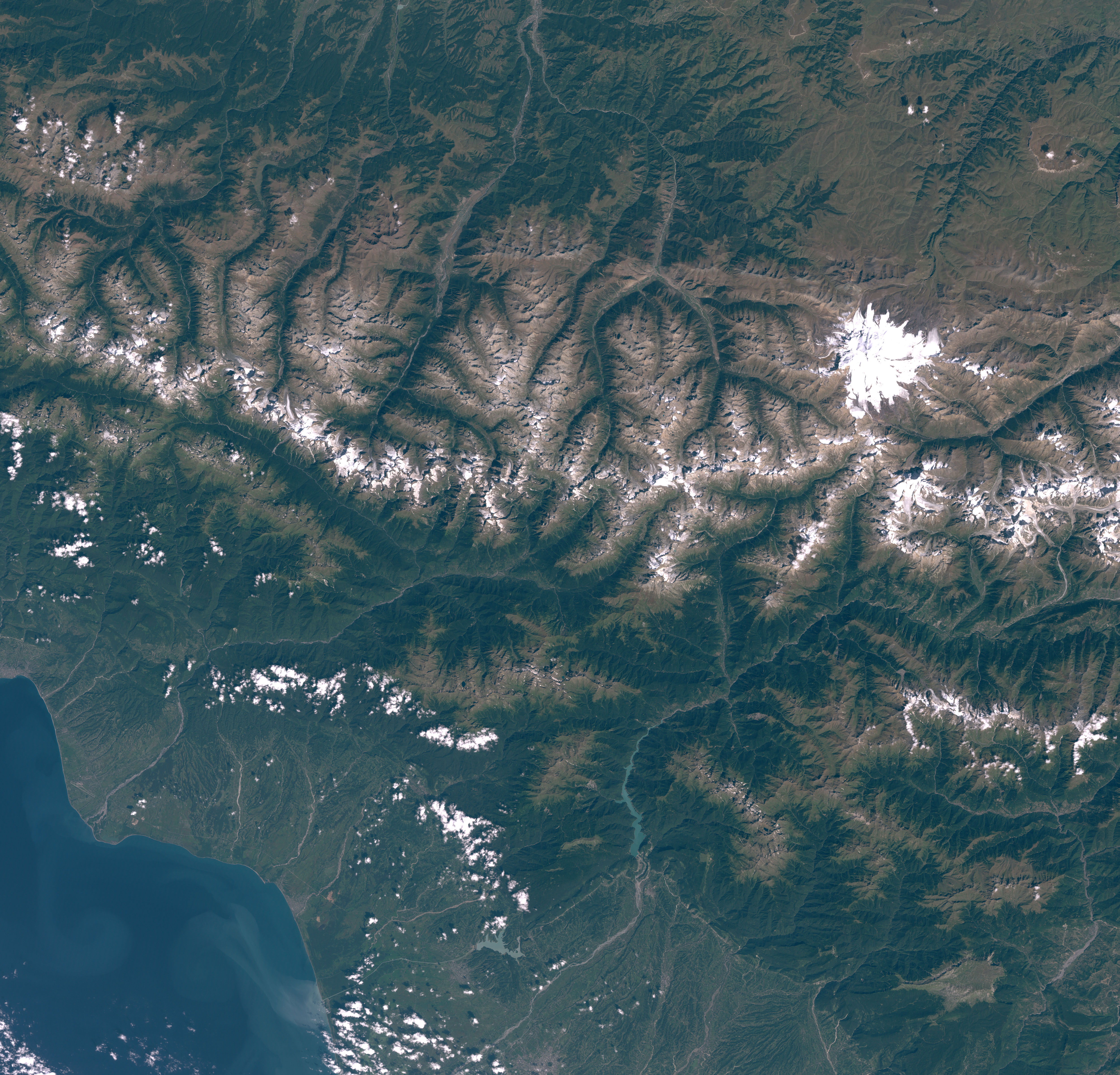
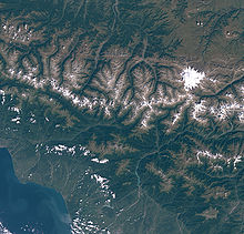 Satellite picture of Mount Elbrus
The ancients knew the mountain as Strobilus, Latin for 'pine cone', a direct loan from the ancient Greek strobilos, meaning 'a twisted object' – a long established botanical term that describes the shape of the volcano's summit. Myth held that here Zeus had chained Prometheus, the Titan who had stolen fire from the gods and given it to ancient man – likely a reference to historic volcanic activity.
The lower of the two summits was first ascended on 10 July 1829 (Julian calendar) by Khillar Khachirov, a Karachay[9] guide for an Imperial Russian army scientific expedition led by General Emmanuel, and the higher (by about 40 m—130 ft) in 1874 by an English expedition led by F. Crauford Grove and including Frederick Gardner, Horace Walker, and Swiss climber Peter Knubel. During the early years of the Soviet Union, mountaineering became a popular sport of the masses, and there was tremendous traffic on the mountain. In the winter of 1936, a very large group of inexperienced Komsomol members attempted the mountain, and ended up suffering many fatalities when they slipped on the ice and fell to their deaths. The Wehrmacht occupied the area surrounding the mountain from August 1942 to January 1943,[10] during World War II, with 10,000 soldiers of a Gebirgsjäger (Mountain Troop) division. A possibly apocryphal story tells of a Soviet pilot being given a medal for bombing the main mountaineering hut, Priyut 11 (Приют одиннадцати, "Refuge of the 11"), while it was occupied. He was then later nominated for a medal for not hitting the hut, but instead the German fuel supply, leaving the hut standing for future generations. When news reached Adolf Hitler that a detachment of mountaineers was sent by the general officer commanding the German division to climb to the summit of Elbrus and plant the swastika flag at its top, he reportedly flew into a rage, called the achievement a "stunt" and threatened to court martial the general.[11]
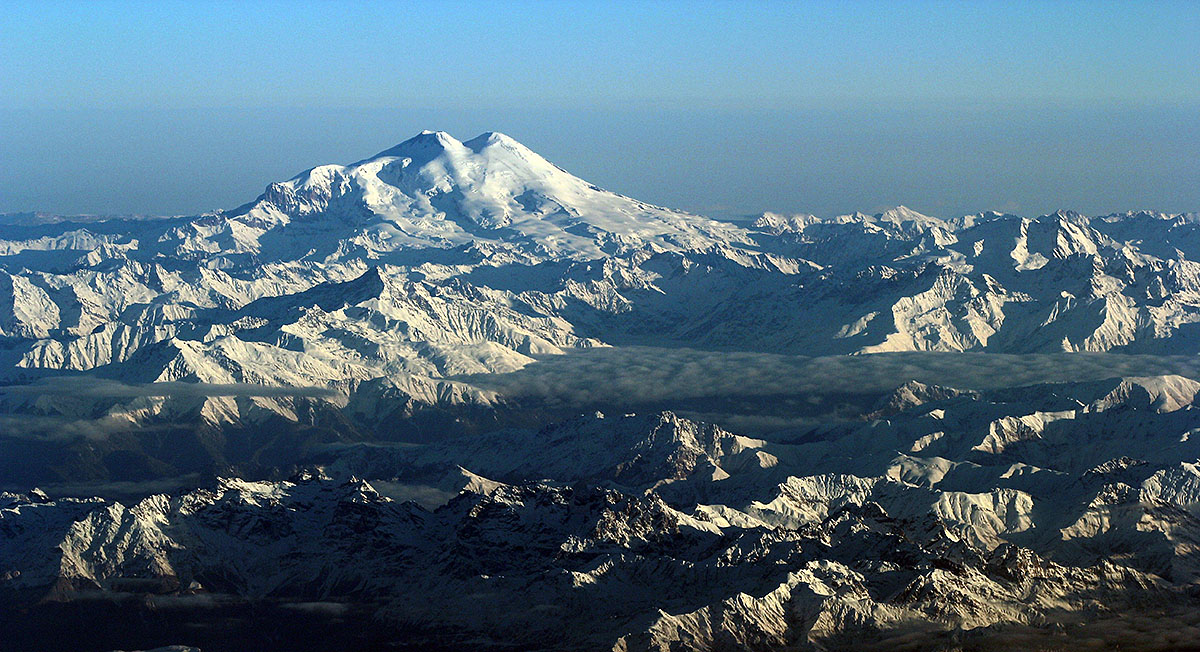
 Mount Elbrus and its two peaks
The Soviet Union encouraged ascents of Elbrus, and in 1956 it was climbed en masse by 400 mountaineers to mark the 400th anniversary of the incorporation of Kabardino-Balkaria, the Autonomous Soviet Socialist Republic where Elbrus was located.
From 1959 through 1976, a cable car system was built in stages that can take visitors as high as 3,800 metres (12,500 ft). There is a wide variety of routes up the mountain, but the normal route, which is free of crevasses, continues more or less straight up the slope from the end of the cable car system. During the summer, it is not uncommon for 100 people to be attempting the summit via this route each day. Winter ascents are rare, and are usually undertaken only by very experienced climbers. Elbrus is notorious for its brutal winter weather, and summit attempts are few and far between. The climb is not technically difficult, but it is physically arduous because of the elevations and the frequent strong winds. The average annual death toll on Elbrus is 15–30, primarily due to "many unorganized and poorly equipped" attempts to summit the mountain.[12]
Mount Elbrus should not be confused with the Alborz (also called Elburz) mountains in Iran, which also derive their name from the legendary mountain Harā Bərəzaitī in Persian mythology.
Parts of this article are from the NASA Earth Observatory[13]
In 1997, a Land Rover Defender was driven to the summit, breaking into the Guinness Book of Records.[14]
Climbing routes
Main article: Elbrus climbing routesThe Normal Route is the easiest, safest and fastest on account of the cable car and chairlift system which operates from about 9am till 3pm. Starting for the summit at about 2am from the Diesel Hut should allow just enough time to get back down to the chairlift if movement is efficient. A longer ascent Kiukurtliu Route starts from below the cable-way Mir station and heads west over glacier slopes towards the Khotiutau pass.
Climbing Elbrus from other directions is a tougher proposition because of lack of permanent high facilities. Douglas Freshfield always maintained that a route from the east up the Iryk valley, Irykchat glacier and over the Irykchat pass (3667m) on to snowfields below long rock ribs of the east spur would become the shortest and most used approach.
Three permits are required for climbing. Foreigners need a Border Zone Permit to be in any area south of Baksan. Prielbrusie National Park Permit is required for access to the park. Foreigners also must be registered in OVIR (Visa and Registration department) in Tyrnyauz.
Environmental issues
Mount Elbrus is said to be home to the 'world's nastiest' outhouse which is close to being the highest privy in Europe. The title was conferred by Outside magazine following a 1993 search and article.[15] The outhouse is surrounded by and covered in ice, perched off the end of a rock.[16]
See also
References
- ^ The World Book Encyclopedia—Page 317 by World Book, Inc
- ^ Mount Elbrus Map Sample
- ^ EWP (2007). Mount Elbrus and Upper Baksan Valley Map and Guide (Map). 1:50,000 with mountaineering information. EWP Map Guides. Cartography by EWP (2nd ed.). ISBN 978 0906227954. http://www.ewpnet.com/elbrumap.htm.
- ^ a b "Elbrus: Summary". Global Volcanism Program. Smithsonian Institution. http://www.volcano.si.edu/world/volcano.cfm?vnum=0104-01-. Retrieved February 25, 2010.
- ^ Geographic Bureau. "Elbrus Region". http://www.geographicbureau.com/trips/caucasus/elbrus_region.jdx. Retrieved 2010-01-05.
- ^ a b c d e Encyclopædia Iranica, "Alborz", W. Eilers
- ^ Robin Collomb and Andrew Wielochowski (1993). Caucasus from Elbrus to Kazbek (Map). 1:200,000 with general information. Map Guides. Cartography by EWP (1st ed.). ISBN 906227-54-2. http://www.ewpnet.com/CAUCCMAP.HTM.
- ^ "Observations of crustal tide strains in the Elbrus area". Izvestiya Physics of the Solid Earth (MAIK Nauka) 43 (11): 922–930. November 2007. http://www.springerlink.com/content/48797w21g448x580/. Retrieved February 25, 2010.
- ^ Schamyl and Circassia by Friedrich Wagner Shacmil: Noah's Ark, pp.27
- ^ Mount Elbrus History.
- ^ Kershaw, Ian. Hitler: Nemesis 1936–1945.
- ^ SummitPost—Interview with Boris Tilov—the Chef of the rescue service of Elbrus region—Trip Reports
- ^ EO Newsroom: New Images—Mt. Elbrus
- ^ Land Rover Defender climbs Mount Elbrus, ExplorersWeb (January 18, 2004)
- ^ Flinn, John (2006-04-09). "The pinnacle of success—and—disgust—for climbers". San Francisco Chronicle. http://www.sfgate.com/cgi-bin/article.cgi?f=/c/a/2006/04/09/TRGU3I3MIM1.DTL.
- ^ Getting to the Top In the Caucasus, New York Times (August 27, 1989)
- Anthony Huxley, Standard Encyclopedia of the World's Mountains (New York: Putnam, 1962)
External links
- Mount Elbrus on CHEBANDA
- Mount Elbrus on SummitPost
- "Elbrus, Mount." Encyclopædia Britannica. 2006. Encyclopædia Britannica Online. 14 Nov. 2006 <http://www.britannica.com/eb/article-9032240>.
- Computer generated summit panoramas North South. There are a few discontinuities due to incomplete data. Politically the Caucasus are in Europe but topographically they are in Asia.
- NASA Earth Observatory pages on Mount Elbrus: Mt. Elbrus (July 2003), Mt. Elbrus, Caucasus Range (Nov 2002)
- Mt. Elbrus Expedition Cybercast Archives
- Elbrus Photos (Hundreds of large photographs of Mt. Elbrus and the vicinity)
- A trip report
- Topographic map of Caucasus
Seven Summits Asia - Everest (8,848 m/29,029 ft)
South America - Aconcagua (6,962 m/22,841 ft)
North America - Mount McKinley (6,198 m/20,335 ft)
Africa - Kilimanjaro (5,893 m/19,334 ft)
Europe - Elbrus (5,642 m/18,510 ft)
- or Mont Blanc (4,810 m/15,781 ft)
Antarctica - Vinson Massif (4,892 m/16,050 ft)
Oceania - Puncak Jaya (4,884 m/16,024 ft)
- or Mount Wilhelm (4,509 m/14,793 ft)
- or Mount Kosciuszko (2,228 m/7,310 ft)
Volcanic Seven Summits - South America: Ojos del Salado
- Africa: Kilimanjaro
- Asia: Damavand
- Europe: Elbrus
- North America: Pico de Orizaba
- Australia (Oceania): Giluwe
- Antarctica: Sidley
Categories:- Mountains of Russia
- Inactive volcanoes
- Stratovolcanoes of the Caucasus
- Seven Summits
- Volcanic Seven Summits
- Extreme points of Earth
- Kabardino-Balkaria
- Volcanoes of Russia


Wikimedia Foundation. 2010.