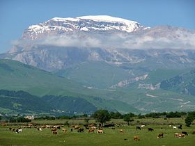
- Mount Shahdagh
-
Mount Shahdagh Elevation 4,243 m (13,921 ft) Listing Ultra Location Location  Azerbaijan
Range Greater Caucasus Mount Shahdagh (Azerbaijani: Şahdağ) is a mountain peak of the Greater Caucasus range, located in Qusar rayon of Azerbaijan, close to the border with Russia. The elevation of the peak is 4,243 metres above the sea level.[1] Prehistoric cave dwellings have been discovered at the base of the mountain indicating habitation for over 9,000 years. Among the earth rocks found in Shahdag are magnesian lime, chalkstone and marble.[2]
In February 2007 an Azerbaijani team of eight climbers ascended Shahdag, but could not reach the unconquered peak, which is still one of the last remaining unclimbed summits of Azerbaijan, because the tall cliffs surrounding it on all sides and strong winds make it extremely difficult and dangerous.[3]
The ascent was done under extreme conditions of an unusual route through frozen waterfalls, that are frozen at the foot of the mountain, attended by eight of the most experienced climbers of the country. Such an ascent is possible on Shahdag only during the winter season, when the hundred-meter waterfalls flowing down the slopes of the mountain, turn into giant ice blocks.[3]
Since the mountain is entirely bordered on all sides by tall cliffs, the only approach of climing the mountain is only with climbing gear through the above mentioned technical rock and waterfall climbing routes.[3]
Winter temperatures at Shahdag average -20°C.[3]
References
- ^ "Большая советская энциклопедия. Шахдаг [Great Soviet Encyclopedia. Shahdag]". http://slovari.yandex.ru/~книги/БСЭ/Шахдаг/. Retrieved 2011-08-09. (Russian)
- ^ "Большой энциклопедический словарь Брокгауза и Ефрона. Шахдаг [Brockhaus and Efron Encyclopedia Dictionary. Shahdag]". http://gatchina3000.ru/big/115/115023_brockhaus-efron.htm. Retrieved 2011-08-09. (Russian)
- ^ a b c d "Альпинисты Азербайджана совершили зимнее восхождение на одну из самых высоких вершин страны - гору Шахдаг [Azerbaijani alpinists climbed to one of the highest peaks of the country - Mount Shahdag]". Novosti Azerbaijan. 2007-02-10. http://www.newsazerbaijan.ru/sport/20070210/41636371.html. Retrieved 2011-08-09. (Russian)
External links
Ultra prominent peaks of Europe Scandinavia Galdhøpiggen • Kebnekaise • Jiehkkevárri • Snøhetta • Store Lenangstind • Sarektjåhkkå — On islands: Beerenberg • Hvannadalshnúkur • Newtontoppen • Novaya Zemlya HPWestern Europe Atlantic islands Alps Mont Blanc • Grossglockner • Finsteraarhorn • Wildspitze • Bernina • Hochkönig • Monte Rosa • Hoher Dachstein • Marmolada • Viso • Triglav • Barre des Écrins • Säntis • Ortler • Baldo • Gran Paradiso • Coca • Cima Dodici • Dents du Midi • Chamechaude • Zugspitze • Antelao • Arcalod • Grintovec • Großer Priel • Grigna Settentrionale • Bondone • Presanella • Birnhorn • Col Nudo • Pointe Percée • Montasch • Polinik • Tödi • Birkkarspitze • Wilder Kaiser • Grande Tête de l'Obiou • Cima Tosa • Hochtor • Grimming • Grand Combin • Tournette • Zirbitzkogel • KeschItaly Eastern Europe Carpathians: Gerlachovský štít • Parângu Mare • Moldoveanu • Peleaga — Crimea: Roman-Kosh — Urals: NarodnayaBalkans Mediterranean islands Caucasus Elbrus • Bazardüzü • Kazbek • Tebulosmta • Aragats • Dykh-Tau • Dyultydag • Kapudzhukh • Gora Addala Shukgelmezr • Shani • ShahdaghCoordinates: 41°16′21″N 48°00′16″E / 41.2725°N 48.0044°E
Categories:- Landforms of the Caucasus
- Mountains of Azerbaijan
- Geography of the Caucasus
- Azerbaijan geography stubs
Wikimedia Foundation. 2010.

