- 1991 Perfect Storm
-
"Halloween Storm" redirects here. For the 2011 nor'easter, see 2011 Halloween nor'easter.
1991 Perfect Storm Category 1 hurricane (SSHS) 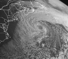
The Perfect Storm to the south of Nova Scotia Formed October 28, 1991 Dissipated November 4, 1991 Highest winds 1-minute sustained:
75 mph (120 km/h)Lowest pressure 972 mbar (hPa; 28.7 inHg) Fatalities 13 direct Damage > $200 million (1991 USD) Areas affected East Coast of the United States, Atlantic Canada Part of the 1991 Atlantic hurricane season The 1991 Perfect Storm, also known as the Halloween Nor'easter of 1991, was a nor'easter that absorbed Hurricane Grace and ultimately evolved into a small hurricane late in its life cycle. The initial area of low pressure developed off Atlantic Canada on October 28. Forced southward by a ridge to its north, it reached its peak intensity as a large and powerful cyclone. The storm lashed the East Coast of the United States with high waves and coastal flooding, before turning to the southwest and weakening. Moving over warmer waters, the system transitioned into a subtropical cyclone before becoming a tropical storm. It executed a loop off the Mid-Atlantic states and turned toward the northeast. On November 1 the system evolved into a full-fledged hurricane with peak winds of 75 miles per hour (120 km/h), although the National Hurricane Center left it unnamed to avoid confusion amid media interest in the predecessor extratropical storm. It later received the name "the Perfect Storm" after a conversation between Boston National Weather Service forecaster Robert Case and author Sebastian Junger. The system was the fourth hurricane and final tropical cyclone in the 1991 Atlantic hurricane season. The tropical system weakened, striking Nova Scotia as a tropical storm before dissipating.
Damage from the Perfect Storm totaled over $200 million (1991 USD)[1] and the death toll was thirteen. Most of the damage occurred while the storm was extratropical, after waves up to 30 feet (10 m) struck the coastline from Canada to Florida and southeastward to Puerto Rico. In Massachusetts, where damage was heaviest, over 100 homes were destroyed or severely damaged. To the north, more than 100 homes were affected in Maine, including the vacation home of then-President George H. W. Bush. More than 38,000 people were left without power, and along the coast high waves inundated roads and buildings. In portions of New England, damage was worse than Hurricane Bob had caused two months earlier.
Aside from tidal flooding along rivers, the storm's effects were primarily concentrated along the coast. A buoy off the coast of Nova Scotia reported a wave height of 100.7 feet (30.7 m), the highest ever recorded in the province's offshore waters. In the middle of the storm, the Andrea Gail sank, killing its crew of six and inspiring the book, and later movie, The Perfect Storm. Off the shore of New York's Long Island, an Air National Guard helicopter ran out of fuel and crashed; four members of its crew were rescued, and one was killed. Two people died after their boat sank off Staten Island. High waves swept people to their deaths in Rhode Island and Puerto Rico, and another person was blown off a bridge to his death. The tropical cyclone that formed late in the storm's duration caused little impact, limited to power outages and slick roads; one person was killed in Newfoundland from a traffic accident related to the storm.
Contents
Meteorological history
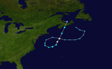 Storm track beginning southeast of Canada as an extratropical storm, moving westward toward New England, becoming tropical as it looped to the northeast, and later dissipating over Prince Edward Island
The Perfect Storm originated from a cold front that exited the east coast of the United States. On October 28, the front spawned an extratropical low to the east of Nova Scotia. Around that time, a ridge extended from the Appalachian Mountains northeastward to Greenland, with a strong high pressure center over eastern Canada. The blocking ridge forced the extratropical low to track toward the southeast and later to the west. Hurricane Grace was swept aloft by its cold front into the warm conveyor belt circulation of the deep cyclone on October 29. The cyclone significantly strengthened as a result of the temperature contrast between the cold air to the northwest and the warmth and humidity from the remnants of Hurricane Grace. The low pressure system continued deepening as it drifted toward the United States.[2] It had an unusual retrograde motion for a nor'easter, beginning a set of meteorological circumstances that occur only once every 50 to 100 years.[3] Most nor'easters affect New England from the southwest.[4]
 The tropical storm making landfall west of Halifax, Nova Scotia, Canada
While situated about 390 miles (630 km) south of Halifax, Nova Scotia, the storm attained its peak intensity with winds of up to 70 mph (110 km/h).[2] The nor'easter reached peak intensity at approximately 12:00 UTC on October 30 with its lowest pressure of 972 millibars. The interaction between the extratropical storm and the high pressure system to its north created a significant pressure gradient, which created large waves and strong winds.[2] Between the southern New England coast and the storm's center, the gradient was 70 mbar (2.1 inHg).[5] A buoy located 264 miles (425 km) south of Halifax reported a wave height of 100.7 feet (30.7 m) on October 30. This became the highest recorded wave height on the Scotian Shelf, which is the oceanic shelf off the coast of Nova Scotia.[6] East of Cape Cod, a NOAA buoy located at 41°06′N 66°36′W / 41.1°N 66.6°W reported maximum sustained winds of 56 mph (90 km/h) with gusts to 75 mph (121 km/h), and a significant wave height (average height of the highest waves) of 39 feet (12 m) around 15:00 UTC on October 30. Another buoy, located at 40°30′N 69°30′W / 40.5°N 69.5°W, reported maximum sustained winds of 61 mph (98 km/h) with gusts to 72 mph (116 km/h) and a significant wave height of 31 feet (9.4 m) near 00:00 UTC on October 31.[2]
Upon peaking in intensity, the nor'easter turned southward and gradually weakened; by November 1, its pressure had risen to 998 millibars (29.5 inHg). The low moved over warm waters of the Gulf Stream, where bands of convection around the center began to organize.[7] Around this time, the system attained subtropical characteristics. On November 1, while the storm was moving in a counter-clockwise loop, a tropical cyclone had been identified at the center of the larger low.[8] (Although these conditions are rare, Hurricane Karl during 1980 also formed within a larger non-tropical weather system.)[9]
By around 14:00 UTC on November 1, an eye feature was forming, and the tropical cyclone reached its peak intensity with maximum sustained winds of 75 mph (121 km/h);[10][11] these estimates, combined with reports from an Air Force Reserve Unit flight into the storm and confirmation that a warm-core center was present, indicated that the system had become a Category 1 hurricane on the Saffir–Simpson Hurricane Scale. The hurricane accelerated toward the northeast and quickly weakened back into a tropical storm. It made landfall near Halifax, Nova Scotia, at 14:00 UTC on November 2 with sustained winds of 45 mph (72 km/h). While the storm was approaching the coast, weather radars depicted curved rainbands on the western side of the system.[8] After crossing over Prince Edward Island,[6] it fully dissipated late on November 4.[8]
Preparations and naming
 Satellite image of the unnamed hurricane
For several days, weather models forecast the development of a significant storm off New England.[5] However, the models were inadequate in forecasting coastal conditions, which in one instance prevented adequate warning. In addition, a post-storm assessment found an insufficient number of observation sites along the coast.[12] On October 27, the Ocean Prediction Center noted that a "dangerous storm" would form within 36 hours, with its wording emphasizing the unusual nature of the storm.[13] The National Weather Service likewise issued warnings for the potential storm, providing information to emergency service offices as well as the media.[12] The public however was skeptical and did not recognize the threat.[3][12] The timely warnings ultimately lowered the death toll;[12] whereas the Perfect Storm caused 13 deaths, the blizzard of 1978 killed 99 people, and the 1938 New England hurricane killed 564 people.[5]
From Massachusetts to Maine, thousands of people evacuated their homes and sought shelter.[14] A state of emergency was declared for nine counties in Massachusetts, including Suffolk County, as well as two in Maine.[4][15] In North Carolina, the National Weather Service offices in Hatteras and Raleigh first issued a heavy surf advisory on October 27, more than eight hours before the first reports of high waves. That same day, a coastal flood watch and later a warning was issued, along with a gale warning. The Hatteras NWS office ultimately released 19 coastal flood statements, as well as media reports explaining the threat from the wind and waves, and a state of emergency was declared for Dare County, North Carolina.[14] The warnings and lead times in the region were described as "very good".[16]
In Canada, the threat from the storm prompted the cancellation of ferry service from Bar Harbor, Maine, to Yarmouth, Nova Scotia, as well as from Nova Scotia to Prince Edward Island and between Nova Scotia and Newfoundland.[6]
In its tropical cyclone report on the hurricane, the National Hurricane Center only referred to the system as "Unnamed Hurricane".[7] The Natural Disaster Survey Report called the storm "The Halloween Nor’easter of 1991".[5] The "perfect storm" moniker was coined by author and journalist Sebastian Junger after a conversation with NWS Boston Deputy Meteorologist Robert Case in which Case described the convergence of weather conditions as being "perfect" for the formation of such a storm.[3] Other National Weather Service offices were tasked with issuing warnings for this storm in lieu of the typical NHC advisories. The OPC posted warnings on the unnamed hurricane in its High Seas Forecasts. The National Weather Service State Forecast Office in Boston issued Offshore Marine Forecasts for the storm. Local NWS offices along the East coast covered the storm in their Coastal Waters Forecasts.[17]
Beginning in 1950, the National Hurricane Center named officially recognized tropical storms and hurricanes. The unnamed hurricane was reported to have met all the criteria for a tropical cyclone, but it was purposefully left unnamed. This was done to avoid confusion among the media and the public, who were focusing on the damage from the initial nor'easter, as the hurricane itself was not expected to pose a major threat to land. It was the eighth nameable storm of the 1991 Atlantic hurricane season.[8][18]
Effects
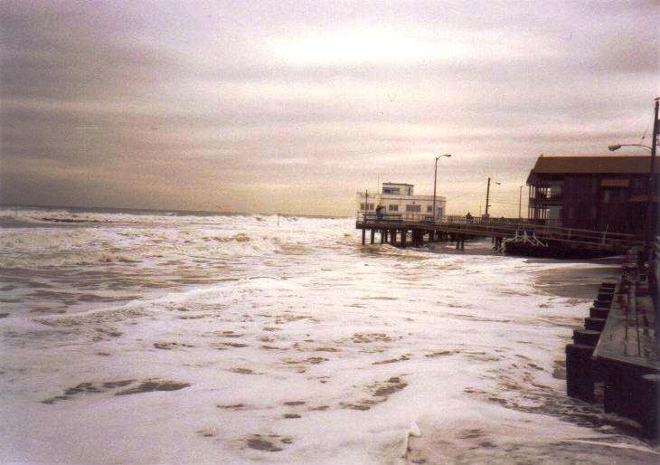
 Oceanfront flooding in Ocean City, New Jersey
The Halloween Storm of 1991 left significant damage along the east coast of the United States, primarily in Massachusetts and southern New Jersey. Across seven states, damage totaled over $200 million (1991 USD).[1] Over a three-day period, the storm lashed the northeastern United States with high waves,[5] causing damage to beachfront properties from North Carolina to Maine.[12] The coastal flooding damaged or destroyed hundreds of homes and businesses and closed roads and airports.[2] In addition, high winds left at least 38,000 people without power. The total without power was much less than for Hurricane Bob two months prior, and was fairly low due to little rainfall and the general lack of leaves on trees.[15] Overall there were thirteen confirmed deaths,[5][6] including six on board the Andrea Gail, a swordfishing boat. The vessel departed Gloucester, Massachusetts, for the waters off Nova Scotia. After encountering high seas in the middle of the storm, the vessel made its last radio contact late on October 28 about 180 miles (290 km) northeast of Sable Island. The Andrea Gail sank while returning to Gloucester, its debris washing ashore over the subsequent weeks. The crew of six was presumed killed after a Coast Guard search was unable to find them. The storm and the boat's sinking became the center-piece for Sebastian Junger's best-selling non-fiction book The Perfect Storm (1997), which was adapted to a major Hollywood film in 2000 as The Perfect Storm starring George Clooney.[2][19]

Despite the storm's severity, it was neither the costliest nor the strongest to affect the northeastern United States. It was weakening as it made its closest approach to land, and the highest tides occurred during the neap tide, which is the time when tide ranges are minimal.[5] The worst of the storm effects stayed offshore. A buoy 650 miles (1,050 km) northeast of Nantucket, which was 60 miles (97 km) west of the Andrea Gail's last known position, recorded a 73 ft (22 m) rise in wave height in 10 hours while the extratropical storm was still rapidly intensifying. Two buoys near the Massachusetts coast observed record wave heights, and one observed a record wind report.[5] The United States Coast Guard rescued at least 25 people at sea at the height of the storm,[20] including 13 people from Long Island Sound.[4] A national guard helicopter crashed during the storm 90 miles (140 km) south of Montauk, New York, after it ran out of fuel. After one helicopter attempted a rescue in the midst of the storm, an 18-person crew on the coast guard cutter Tamaroa arrived and rescued four members of the crew of five after six hours in hypothermic waters. The last member was never found.[4][15][21]
Following the storm's damage, President George Bush declared five counties in Maine, seven counties in Massachusetts, and Rockingham County, New Hampshire to be disaster areas.[1] The declaration allowed for the affected residents to apply for low-interest repair loans.[22] New Jersey governor Jim Florio requested a declaration for portions of the coastline, but the request was denied because of the funding needs of other disasters, such as Hurricane Hugo, Hurricane Bob, and the 1989 Loma Prieta earthquake.[23] The American Red Cross opened service centers in four locations in Massachusetts to assist the storm victims by providing food, clothing, medicine, and shelter. The agency deployed five vehicles carrying cleanup units and food, and also allocated $1.4 million to provide assistance to 3,000 families.[22]
New England and Atlantic Canada
Along the Massachusetts coastline, the storm produced 25 ft (7.6 m) wave heights on top of a 4 ft (1.2 m) high tide.[1] In Boston, the highest tide was 14.3 ft (4.4 m),[5] which was only 1 ft (30 cm) lower than the record from the blizzard of 1978.[1] High waves on top of the storm tide reached about 30 ft (9.1 m). The storm also produced heavy rainfall in southeastern Massachusetts, peaking at 5.5 inches (140 mm).[5] Coastal floods closed several roads, forcing hundreds of people to evacuate. In addition to the high tides, the storm produced strong winds; Chatham recorded a gust of 78 mph (126 km/h). Damage was worst from Cape Ann in northeastern Massachusetts to Nantucket, with over 100 homes destroyed or severely damaged at Marshfield, North Beach, and Brant Point. There were two injuries in the state, although there were no fatalities. Across Massachusetts, damage totaled in the hundreds of millions of dollars.[1]
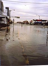 Street flooding in Ocean City, New Jersey, from the storm
Elsewhere in New England, waves up to 30 ft (9.1 m) reached as far north as Maine,[1] along with tides that were 3 ft (0.91 m) above normal.[20] Significant flooding was reported in that state, along with high winds that left areas without power. A total of 49 houses were severely damaged, 2 were destroyed,[1] and overall more than 100 were affected.[24] In Kennebunkport, the storm blew out windows and flooded the vacation home of then-President George H. W. Bush.[2] The home sustained significant damage to its first floor.[25] In Portland, tides were 3 ft (0.91 m) above normal, among the ten highest tides since record-keeping began in 1914. Along the coast, damage was worse than that caused by Hurricane Bob two months prior.[24] Across Maine, the storm left $7.9 million (1991 USD) in damage,[1] mostly in York County.[24] More than half of the damage total was from property damage, with the remainder to transportation, seawalls, and public facilities.[24] Although there were no deaths, there were two injuries in the state. In neighboring New Hampshire, coastal flooding affected several towns, destroying two homes. The storm destroyed three boats and damaged a lighthouse.[1] High waves destroyed or swept away over 50,000 lobster traps, representing $2 million in losses (1991 USD).[26] Damage was estimated at $5.6 million (1991 USD).[1] Further west, high winds and coastal flooding lashed the Rhode Island and Connecticut coasts, killing a man in Narragansett, Rhode Island. Winds reached 63 miles per hour (101 km/h) in Newport, Rhode Island, causing power outages.[1]
Off the coast of Atlantic Canada, the storm produced very high waves, flooding a ship near Sable Island and stranding another ship. Along the coast, the waves wrecked three small boats near Tiverton, Nova Scotia, as well as nine boats in Torbay, Newfoundland and Labrador. In Nova Scotia, where the storm made landfall, precipitation reached 1.18 in (30 mm), and 20,000 people in Pictou County were left without power. The storm also caused widespread power outages in Newfoundland from its high winds, which reached 68 mph (110 km/h) near St. Lawrence. There were at least 35 traffic accidents, one fatal, in Grand Falls-Windsor due to slick roads. Prior to the storm's formation, there was a record 4.4 in (116 mm) of snowfall across Newfoundland.[6] The storm caused no significant damage in Canada, other than these traffic accidents.[27]
Mid-Atlantic states
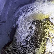 The cyclone near its closest approach to the United States
In New York and northern New Jersey, the storm system left the most coastal damage since the 1944 Great Atlantic hurricane. Numerous boats were damaged or destroyed, killing two people off Staten Island. High winds swept a man off a bridge, killing him.[1] High waves flooded the beach at Coney Island. In Sea Bright, New Jersey, waves washed over a seawall, forcing 200 people to evacuate.[4] Further inland, the Hudson, Passaic, and Hackensack rivers experienced tidal flooding.[2] Outside Massachusetts, damage was heaviest in southern New Jersey, where the cost was estimated at $75 million (1991 USD). Across the area, tide heights reached their highest since the 1944 hurricane, leaving severe coastal and back bay flooding and closing many roads. The storm also caused significant beach erosion,[1] with 500,000 cubic yards (382,000 cubic meters) lost in Avalon, as well as $10 million damage to the beach in Cape May. The presence of a dune system mitigated the erosion in some areas.[23] There was also damage to the Atlantic City Boardwalk.[4] Following the storm, there was a moratorium on clamming in the state's bays, due to contaminated waters.[23] Along the Delmarva Peninsula, there was widespread water damage to homes, including ten affected houses in Sandbridge Beach, Virginia. Tides in Ocean City, Maryland, reached a record height of 7.8 ft (2.4 m), while elsewhere the tides were similar to the Ash Wednesday Storm of 1962.[1]
Further south
In North Carolina along the Outer Banks, high waves were initially caused by Hurricane Grace and later its interaction with a high pressure system. This produced gale-force winds and 12 ft (3.7 m) waves in the town of Duck. Later, the extratropical predecessor to the unnamed hurricane produced additional high waves, causing oceanfront flooding from Cape Hatteras through the northern portions of Currituck County. Flooding was first reported on October 28, when the ocean covered a portion of North Carolina Highway 12 north of Rodanthe;[16] the route is the primary thoroughfare in the Outer Banks.[20] Nags Head, Kitty Hawk, and Kill Devil Hills had large portions covered with water for several blocks away from the beach. The resultant flooding damaged 525 houses and 28 businesses and destroyed two motels and a few homes.[16] Damage was estimated at $6.7 million (1991 USD).[1] Further south, the storm left 14 people injured in Florida. There was minor beach erosion and flooding, which damaged two houses and destroyed the pier at Lake Worth.[1] In some locations, beaches gained additional sand from the wave action.[28] Two people went missing off Daytona Beach after their boat lost power.[4] High waves destroyed a portion of Florida State Road A1A.[29] Damage in the state was estimated at $3 million (1991 USD).[1] High waves also affected Bermuda, the Bahamas, and the Dominican Republic.[2] In Puerto Rico, waves of 15 ft (4.6 m) affected the island's north coast, which prompted 32 people to seek shelter. The waves swept a person off a large rock to their death.[1]
See also
- 1991 Halloween blizzard
- North Atlantic tropical cyclone
- List of New England hurricanes
- List of Canada hurricanes
Notes and references
- ^ a b c d e f g h i j k l m n o p q r s McCown, Sam (2008-08-20). ""Perfect Storm" Damage Summary". National Climatic Data Center. National Oceanic and Atmospheric Administration. http://www.ncdc.noaa.gov/oa/satellite/satelliteseye/cyclones/pfctstorm91/pfctstdam.html. Retrieved 2011-06-20.
- ^ a b c d e f g h i National Climatic Data Center (2008-08-20). "The Perfect Storm". National Oceanic and Atmospheric Administration. http://www.ncdc.noaa.gov/oa/satellite/satelliteseye/cyclones/pfctstorm91/pfctstorm.html. Retrieved 2009-09-14.
- ^ a b c "NOAA Meteorologist Bob Case, the Man Who Named the Perfect Storm". National Oceanographic & Atmospheric Administration News. 2000-06-16. http://www.noaanews.noaa.gov/stories/s444.htm. Retrieved 2011-07-01.
- ^ a b c d e f g Staff writer (1991-10-31). "East battered by storm born off Canada; 4 lost". The Pittsburgh Press. Associated Press. http://news.google.com/newspapers?id=Md8cAAAAIBAJ&sjid=GGQEAAAAIBAJ&pg=6189,8218796&dq=storm+new+england&hl=en. Retrieved 2011-07-03.
- ^ a b c d e f g h i j Drag, Walter (2000-07-14). "A comparative retrospective on the Perfect Storm". Boston National Weather Service Office. http://www.erh.noaa.gov/er/box/PS.htm. Retrieved 2011-07-01.
- ^ a b c d e Canadian Hurricane Centre (2010-09-14). "1991-Unnamed "Perfect Storm"". Environment Canada. http://www.ec.gc.ca/Hurricane/default.asp?lang=En&n=B87EB885-1. Retrieved 2011-06-17.
- ^ a b Pasch, Richard. "Unnamed Hurricane Preliminary Report Page 1". National Hurricane Center. http://www.nhc.noaa.gov/archive/storm_wallets/atlantic/atl1991-prelim/unnamed/prelim01.gif. Retrieved 2009-09-14.
- ^ a b c d National Climatic Data Center. "Unnamed Hurricane". National Oceanic and Atmospheric Administration. http://www.ncdc.noaa.gov/oa/satellite/satelliteseye/hurricanes/unnamed91/unnamed91.html. Retrieved 2009-09-14.
- ^ Pasch, Richard; Avila, Lixion (1992-03-26). "Atlantic Hurricane Season of 1980" (PDF). National Oceanic and Atmospheric Administration. p. 2686. http://www.aoml.noaa.gov/general/lib/lib1/nhclib/mwreviews/1991.pdf. Retrieved 2009-09-13.
- ^ Pasch, Richard. "Unnamed Hurricane Preliminary Report Page 2". National Hurricane Center. http://www.nhc.noaa.gov/archive/storm_wallets/atlantic/atl1991-prelim/unnamed/prelim02.gif. Retrieved 2009-09-14.
- ^ Hurricane Research Division (August 2011). "Atlantic hurricane best track (Hurdat)". National Oceanic and Atmospheric Administration. http://www.aoml.noaa.gov/hrd/hurdat/tracks1851to2010_atl_reanal.html. Retrieved 2011-09-19.
- ^ a b c d e "Executive Summary". National Oceanic and Atmospheric Administration. http://www.nws.noaa.gov/om/assessments/pdfs/pstorm1.pdf. Retrieved 2011-07-01.
- ^ Hoke, Jim (2005-02-16). "The Ocean Prediction Center and "The Perfect Storm"". Oceanic Prediction Center. National Oceanic and Atmospheric Administration. http://www.opc.ncep.noaa.gov/perfectstorm/mpc_ps_intro.shtml. Retrieved 2011-07-01.
- ^ a b Rogers, John (1991-10-31). "Atlantic Storm Wallops East Coast". The Item. Associated Press. http://news.google.com/newspapers?id=7ooiAAAAIBAJ&sjid=F68FAAAAIBAJ&pg=6508,7056631&dq=storm+new+england&hl=en. Retrieved 2011-07-03.
- ^ a b c Staff writer (1991-10-31). "Wind and water take toll along Connecticut Shore". Record-Journal. Associated Press. http://news.google.com/newspapers?id=ihxIAAAAIBAJ&sjid=rgANAAAAIBAJ&pg=1620,180883&dq=storm+new+england&hl=en. Retrieved 2011-07-03.
- ^ a b c Pelissier, Joseph (1991). "North Carolina Coastal Flood" (GIF). National Hurricane Center. http://www.nhc.noaa.gov/archive/storm_wallets/atlantic/atl1991/unnamed/preloc/ncflood1.gif. Retrieved 2011-06-16.
- ^ Pasch, Richard (1991). "Unnamed Hurricane Preliminary Report Page 4". National Hurricane Center. http://www.nhc.noaa.gov/archive/storm_wallets/atlantic/atl1991-prelim/unnamed/prelim04.gif. Retrieved 2011-06-16.
- ^ "Canadian Tropical Cyclone Season Summary for 1991". Canadian Hurricane Centre. 2009-07-10. http://www.ec.gc.ca/ouragans-hurricanes/default.asp?lang=en&n=9D24F0EE-1. Retrieved 2009-09-14.
- ^ Park, Paula (1991-11-11). "Search Ended for Lost Fishermen". Sarasota Herald-Tribune. http://news.google.com/newspapers?id=y64cAAAAIBAJ&sjid=3HsEAAAAIBAJ&pg=6811,330103&dq=andrea+gail&hl=en. Retrieved 2011-07-03.
- ^ a b c Staff writer (2011-09-11). "Storms turn elements loose: waves, flood, snow, wind". Star-News. http://news.google.com/newspapers?id=IlVIAAAAIBAJ&sjid=khQEAAAAIBAJ&pg=6895,6104171&dq=storm+new+england&hl=en. Retrieved 2011-07-03.
- ^ Thiesen, William H. (2010-11-04). "History – CGC Tamaroa and "The Perfect Storm"". Coastguard Compass. http://coastguard.dodlive.mil/2010/11/history-cgc-tamaroa-and-%E2%80%9Cthe-perfect-storm%E2%80%9D/. Retrieved 2011-07-03.
- ^ a b Staff writer (1991-11-02). "Red Cross Opens Assistance Shelters". The Sunday Telegraph. Associated Press. http://news.google.com/newspapers?id=3o5KAAAAIBAJ&sjid=W5QMAAAAIBAJ&dq=storm%20new%20england&pg=6685%2C372289. Retrieved 2011-07-03.
- ^ a b c Buchholz, Margaret; Larry Savadove (1993). Great Storms of the Jersey Shore. Down the Shore Publishing. pp. 148–150. ISBN 0-945582-51-X.
- ^ a b c d Hidlay, William C. (1991-11-01). "Maine hit hard by storm". Bangor Daily News. Associated Press. http://news.google.com/newspapers?id=DqhJAAAAIBAJ&sjid=KQ4NAAAAIBAJ&pg=3345,8099&dq=storm+new+england&hl=en. Retrieved 2011-07-03.
- ^ Staff writer (1991-10-31). "Bush to assess damage to Kennebunkport home battered by sea". The Pittsburgh Press. Associated Press. http://news.google.com/newspapers?id=Md8cAAAAIBAJ&sjid=GGQEAAAAIBAJ&dq=storm%20new%20england&pg=3692%2C8275025. Retrieved 2011-07-03.
- ^ Staff writer (1991-11-02). "N.H. lobster industry says it was hit hard". The Telegraph. Associated Press. http://news.google.com/newspapers?id=3o5KAAAAIBAJ&sjid=W5QMAAAAIBAJ&pg=2962,372608&dq=storm+new+england&hl=en. Retrieved 2011-07-03.
- ^ Pasch, Richard. "Unnamed Hurricane Preliminary Report Page 3". National Hurricane Center. http://www.nhc.noaa.gov/archive/storm_wallets/atlantic/atl1991-prelim/unnamed/prelim03.gif. Retrieved 2009-09-14.
- ^ Herzog, Carl (1991-11-02). "Erosion is a sampling of hurricane's potential". Boca Raton News. http://news.google.com/newspapers?id=tvVTAAAAIBAJ&sjid=z4wDAAAAIBAJ&pg=6423,469152&dq=storm+new+england&hl=en. Retrieved 2011-07-03.
- ^ Staff writer (1991-11-01). "Wintry blast sends snow into Texas". The News-Journal. http://news.google.com/newspapers?id=Iw8qAAAAIBAJ&sjid=rNQEAAAAIBAJ&pg=3703,111342&dq=storm+new+england&hl=en. Retrieved 2011-07-03.
Categories:- 1991 Atlantic hurricane season
- 1991 in Canada
- 1991 in the United States
- 1991 meteorology
- 1991 Perfect Storm
- Category 1 Atlantic hurricanes
- Hurricanes in Canada
- Nor'easters


Wikimedia Foundation. 2010.