- Ocean Prediction Center
-
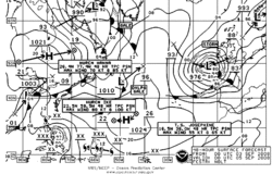 OPC pressure forecast valid at 48 hours
The Ocean Prediction Center (OPC), established in 1995, is one of the National Centers for Environmental Prediction’s (NCEP’s) original six service centers.[1] Until January 12, 2003, the name of the organization was the Marine Prediction Center.[2] Its origins are traced back to the sinking of the RMS Titanic in 1912. The OPC issues forecasts up to 5 days in advance for ocean areas north of 31N latitude and west of 35W longitude in the Atlantic, and across the northeast Pacific north of 30N latitude and east of 160E longitude. Until recently, the OPC provided forecast points for tropical cyclones north of 20N latitude and east of 60W longitude to the National Hurricane Center.[3]
Contents
History
The basis for OPC’s mission can be traced back to the sinking of the Titanic in April 1912. In response to that tragedy, an international commission was formed to determine requirements for safer ocean voyages. In 1914, the commission’s work resulted in the International Convention for the Safety of Life at Sea, of which the United States is one of the original signatories. The OPC assumed the U.S. obligation to issue warnings and forecasts for portions of the North Atlantic and North Pacific oceans.[4]
Products
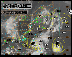 Wave height analysis from OPC
OPC’s Ocean Forecast Branch issues warnings and forecasts in print and graphical formats for up five days into the future. Over 100 forecast products are issued daily. They cover the North Atlantic ocean from the west coast of Europe to the U.S. and Canadian east coasts, and the North Pacific Ocean from the U.S. and Canadian west coast to the east coast of Asia. OPC weather forecasts and warnings for these areas primarily ensure the safety of ocean-crossing commercial ships and other vessels on the high seas. Embedded in these high seas areas are smaller offshore zones off the Atlantic and Pacific coasts. These zones extend from near the coast seaward to just beyond the U.S. Exclusive Economic Zones, out to about 250 nautical miles (460 km). OPC services ensure the safety of the extensive commercial and recreational fishing, boating, and shipping activities in these offshore waters.
OPC began to produce experimental gridded significant wave height forecasts in 2006, a first step toward digital marine service for high seas and offshore areas. Additional gridded products such as surface pressure and winds are under development. Recently, OPC began to use the NWS operational extratropical storm surge model output to provide experimental extratropical storm surge guidance for coastal weather forecast offices to assist them in coastal flood warning and forecast operations.[4]
Role in the unified surface analysis
The OPC provides an important role in the production of the National Weather Service Unified Surface Analysis. After the Hydrometeorological Prediction Center, or HPC, sends out their analysis for the synoptic hour, OPC cuts and stitches the HPC analysis to its area. The Tropical Prediction Center, or TPC, stitches the analysis from the Honolulu Forecast Office onto their map, before it is sent up to OPC. The OPC analysts then stitch together the entire analysis, and send it to the world through their website. The analysis covers much of the Northern Hemisphere, except for eastern Europe and the western half of Asia.[5]
Quality control of marine observations
In 1994, OPC began to quality control global surface marine observations. Using an automated algorithm and interactive system, forecasters examine the latest observations from Voluntary Observing Ships and drifting and moored platforms and compare them against short-projection model runs. Worldwide surface marine observations come to OPC via the World Meteorological Organization’s Global Telecommunications System in real time. These quality control measures remove spurious data before the data are ingested into models to initialize forecasts. Several hundred of these observations are interactively examined daily. In addition, the quality controlled data are used by OPC forecasters to determine if gale, storm, or hurricane force wind warnings are warranted.[4]
Ocean Applications branch
The Ocean Applications Branch plays an important role in enhancing OPC operations and services. One example is the adaptation of ocean surface winds observed from the QuikSCAT satellite in early 2000. Prior to the QuikSCAT launch, there was no ability to observe, verify, and warn of hurricane-force wind conditions, areas where wind speed exceeds 64 knots (119 km/h), often associated with strong winter ocean storms. With QuikSCAT data routinely available in 2000, OPC began to issue hurricane-force wind warnings. In the 2006-2007 winter storm season, over 100 hurricane-force wind warnings were issued for North Pacific and North Atlantic oceans to warn ships of these most severe weather hazard conditions over major shipping routes. Preliminary results from a recent study estimates that in the absence of good information about extra-tropical ocean storms, the annual loss to container and dry bulk shipping would be on the order of more than $500 million. Operational marine warnings and forecasts reduce the above estimated annual loss by nearly one half.
OPC has a number of ongoing research-to-operations transition efforts that will lead to a suite of new oceanographic analysis and forecast products, such as ocean temperatures and currents based on real time observations and advanced global and basin scale ocean forecasting models. Global ocean sea surface temperatures and currents are now available on the OPC website.[4]
See also
- Environmental Modeling Center
- Hydrometeorological Prediction Center
- Space Environment Center
- Storm Prediction Center
- Tropical Prediction Center
References
- ^ Stephanie Kenitzer (1995-05-18). "NOAA Creates National Centers for Environmental Prediction". National Oceanic and Atmospheric Administration. http://www.publicaffairs.noaa.gov/pr95/may95/ncep.html. Retrieved 2008-09-03.
- ^ Ocean Prediction Center (2004). Ocean Prediction Center: 2003 Accomplishments. Retrieved on 2008-09-03.
- ^ Staff Writer, Ocean Prediction Center (2005-01-05). "Vision & Mission Statement". National Weather Service. http://www.opc.ncep.noaa.gov/abtopc.shtml. Retrieved 2008-09-03.
- ^ a b c d David Feit (2008-06-19). "Ocean Prediction Center: Overview". Ocean Prediction Center. http://www.opc.ncep.noaa.gov/OPC_Overview_ESM.shtml. Retrieved 2008-09-03.
- ^ "Unified Surface Analysis Manual" (pdf). Hydrometeorological Prediction Center. 2006-12-14. http://www.hpc.ncep.noaa.gov/sfc/UASfcManualVersion1.pdf. Retrieved 2008-09-03.
Categories:- National Weather Service
- Shipping
- Weather prediction


Wikimedia Foundation. 2010.