- Geology of New Zealand
-
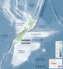 The continent of Zealandia
The geology of New Zealand is noted for its volcanic activity, earthquakes and geothermal areas because of its position on the boundary of the Australian Plate and Pacific Plates.
New Zealand was earlier part of the super-continent of Gondwana, along with South America, Africa, Madagascar, India, Antarctica and Australia. The rocks that now form New Zealand were nestled between Eastern Australia and Western Antarctica.[1]
Basement rocks
The oldest rocks in New Zealand date from mid Cambrian times (510 Ma), although there are older rocks in the Auckland Islands. The basement rocks are divided into the “Western Province”, consisting mainly of granite and gneiss, and an “Eastern Province”, consisting mainly of greywacke and schist. The provinces are further divided into terranes – large slices of crust, that have a different geological history, that have been brought together by tectonic activity (subduction and strike-slip faulting) to form New Zealand.
The plutonic basement rocks are subdivided into the Hohonu, Karamea, Median and Paparoa batholiths, that solidified from magma deep in the crust. These rocks form the foundations beneath offshore Taranaki, and the West Coast, Buller, Northwest Nelson, Fiordland and Stewart Island. Most New Zealand granites were formed in Devonian-Carboniferous time (380-335 Ma) and Jurassic-Cretaceous time (155-100 Ma). The rocks can be matched to similar rocks in Eastern Australia.
The sedimentary basement rocks are subdivided into the Western Province Buller and Takaka terranes, and the Eastern Province Brook Street, Murihiku, Maitai, Caples, Torlesse Composite (Rakaia and Pahau) and Waipapa Composite (Morrinsville and Hunua) terranes. The Western Province sedimentary rocks form the foundations beneath the Northwestern portion of the South Island, to the West of the Alpine Fault, and Fiordland. The Eastern Province sedimentary rocks form the foundation for the rest of New Zealand. They are mostly composed of greywacke together with argillite.
The Alpine Fault that corresponds to the line of the Southern Alps has separated the basement rocks that used to be adjacent by about 460 km. For example, Nelson and Southland used to be adjacent, as were Marlborough and Otago.
In general, the sedimentary basement terranes become younger from West to East across the country, as the newer terranes were scraped off the subducting paleo-Pacific Plate, and accreted to the boundary of Gondwana over hundreds of millions of years.
The Buller and Takaka terranes of the Western Province formed in Cambrian-Devonian time (510-400 Ma) and contain New Zealand’s oldest greywacke.
The Median Batholith represents a long-lived batholith dividing the Western and Eastern Provinces, and before the separation of Gondwana, stretched from Queensland, through what is now New Zealand, into West Antarctica. It marks the site of a former subduction zone on the edge of Gondwana.
The Central Arc Terranes (Brook Street, Murihiku and Maitai Terranes) are of Carboniferous-Jurassic age (310-165 Ma), and are believed to be related to ancient volcanic arcs. They contain sandstone and mudstone derived from volcanic rock, and some limestone. The Brook Street terrane contains Glossopteris fossils, linking New Zealand to Gondwana. The Maitai terrane includes the Dun Mountain Ophiolite Belt, which contains dark serpentinised ultramafic rocks. These rocks form a line (split by the Alpine Fault) throughout the length of the country that can be detected by the magnetic anomaly it produces. Ophiolites are slices of oceanic crust and magma that have been detached from a subducting plate, and obducted onto the continental crust above the subduction zone.
The Caples, Torlesse Composite (Rakaia and Pahau) and Waipapa Composite (Morrinsville and Hunua) terranes formed in Carboniferous-Cretaceous time (330-120 Ma). Much of the rocks were deposited as submarine fans. They have different origins, as shown by different chemical compositions and different fossils.
Many rocks in the Western Province (Paparoa, Fiordland and Stewart Island) have been metamorphosed into gneiss. Many rocks in the Eastern Province have been metamorphosed into schist, due to exposure to high pressures and temperatures. Rocks grade continuously from greywacke (e.g., in Canterbury) to high-grade schist (e.g., around the Caples-Torlesse boundary in Otago and Marlborough, and Torlesse rocks just to the East of the Alpine Fault).
Refer to the GNS Map of New Zealand's Geological Foundations.[2]
Separation from Gondwana
New Zealand and New Caledonia represent the visible part of a portion of continental crust, usually referred to as Zealandia. The rest of Zealandia includes the Challenger Plateau and Lord Howe Rise, which stretch from Northwest of New Zealand almost to Northern Australia, and the Campbell Plateau and Chatham Rise, to the southeast of New Zealand.
The Australia-New Zealand continental fragment of Gondwana split from the rest of Gondwana in the late Cretaceous time (95-90 Ma). Then around 83 Ma, Zealandia started to separate from Australia forming the Tasman Sea, initially separating from the south. By 75 Ma, Zealandia was essentially separate from Australia and Antarctica, although only shallow seas might have separated Zealandia and Australia in the north. The landmasses continued to separate until early Eocene times (53 Ma). The Tasman Sea, and part of Zealandia then locked together with Australia to form the Australian Plate (40 Ma), and a new plate boundary was created between the Australian Plate and Pacific Plate. Zealandia ended up at a pivot point between the Pacific and Australian Plates, with spreading in the south, and convergence in the north, where the Pacific Plate was subducted beneath the Australian Plate. A precursor to the Kermadec Arc was created. The convergent part of the plate boundary propagated through Zealandia from the north, eventually forming a proto-Alpine Fault in Miocene times (23 Ma). The various ridges and basins north of New Zealand relate to previous positions of the plate boundary. [3]
Astride a plate boundary
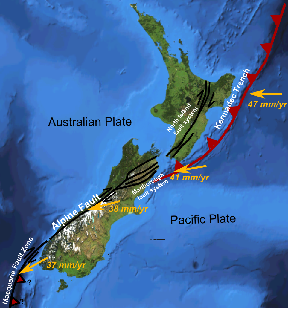
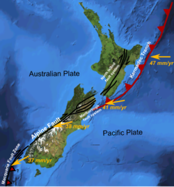 Major active fault zones of New Zealand showing variation in displacement vector of Pacific Plate relative to Australian Plate along the boundary
New Zealand is currently astride the convergent boundary between the Pacific and Australian Plates. The Pacific Plate is subducted beneath the Australian Plate from around Samoa and Tonga in the north, through the Tonga Trench, Kermadec Trench, and Hikurangi Trough to the east of the North Island of New Zealand, down to Cook Strait, and the Marlborough Sounds and Kaikoura region. Through most of the South Island, the plates slide past each other, with slight obduction of the Pacific Plate over the Australian Plate, forming the Alpine Fault and Southern Alps. From Fiordland south, the Australian Plate subducts under the Pacific Plate forming the Puysegur Trench. [4]
Over time, the position of the plate boundary has altered. Around 23 Ma, the convergent plate boundary formed Northland. Around 10 Ma, the Coromandel Ranges were formed. Activity has now moved further East, generating the Kermadec Ridge and Trench, and the Taupo Volcanic Zone. The Southern Alps are quite recent, only forming in the last 10 million years.
Land movement
Because New Zealand straddles a plate boundary, it is tectonically active. The Pacific Plate is colliding with the Australian Plate at a rate of about 40 mm/yr.
The East coast of the North Island is being compressed and lifted by this collision, producing the North Island and Marlborough Fault Systems. The East Coast of the North Island is also rotating clockwise, relative to Northland, Auckland and Taranaki, stretching the Bay of Plenty, and producing the Hauraki Rift (Hauraki Plains and Hauraki Gulf) and Taupo Volcanic Zone.
The East Coast of the South Island is sliding obliquely towards the Alpine Fault, relative to Westland, causing the Southern Alps to rise about 10 mm/yr (although they are also worn down at a similar rate).
The Hauraki Plains, Hamilton, Bay of Plenty, Marlborough Sounds, and Christchurch are sinking. The Marlborough Sounds are known for their sunken mountain ranges. As Wellington rises, and Marlborough sinks, Cook Strait is being shifted further south. [5]
Earthquakes
Main article: Earthquakes in New ZealandDeep earthquakes originate in the subducted plate. Because the Pacific Plate is subducting under the eastern side of the North Island, there are frequent deep earthquakes east of a line from the Bay of Plenty to Nelson (the approximate edge of the subducted plate), with the earthquakes being deeper to the west, and shallower to the east. Because the Australian Plate is subducting under the Pacific Plate in Fiordland, there are frequent deep earthquakes near Fiordland, with the earthquakes being deeper to the east and shallower near the west. There are few deep earthquakes along the Southern Alps, because the two sides largely slide past each other.
Shallow earthquakes are caused by stresses in the top plate. Shallow earthquakes are more widespread, occurring almost everywhere throughout New Zealand (especially the Bay of Plenty, East Cape to Marlborough, and Alpine Fault). However, Northland, Waikato, and Otago are very stable. Canterbury had been very stable until the 7.1 Canterbury Earthquake on 4 September 2010. In the first three weeks following that quake, there were more than 1000 aftershocks in the region.
A Map showing the distribution of earthquakes in New Zealand can be obtained from Te Ara Encyclopedia of New Zealand. [6] Current earthquake and volcanic activity can be obtained from the GeoNet website. [7]
Northland and East Cape allochthons
An allochthon is land that formed elsewhere, and slid on top of other land (in other words, the material of an enormous landslide). Much of the land of Northland and East Cape were created in this manner. Around 25-22 Ma, Northland and East Cape were adjacent, with East Cape near Whangarei. Northland-East Cape was an undersea basin. Much of the land that now forms Northland-East Cape was higher land to the Northeast (composed of rocks formed 90-25 Ma). The Pacific-Australian plate boundary was further to the Northeast, with the Pacific Plate subducting under the Australian Plate. Layers of rocks were peeled off the higher land, from the top down, and slid Southwest under the influence of gravity, to be stacked the right way up, but in reverse order. The last rocks to be slid across were slabs of oceanic crust, mainly basalt. Widespread volcanic activity also occurred (23-15 Ma), and is intermixed with the foreign rocks. East Cape was later separated from Northland and moved further south and east to its present position.
Sedimentary basins
Much of New Zealand was low lying around Mid Eocene-Oligocene times (40-23 Ma). Swamps became widespread, forming coal. The land subsided further, and marine organisms produced limestone deposits. Limestone of Oligocene-Early Miocene age formed in many areas, including the King Country, known for the Waitomo Glowworm Cave. In the South Island, limestone is present in Buller, Nelson, and the West Coast, including the Pancake Rocks at Punakaiki in Oligocene-Early Miocene times (34-15 Ma). Many of New Zealand's limestone deposits were formed in relatively cool seas.
Volcanic activity
Main article: Volcanism in New ZealandWhen a plate is subducted under another plate, it causes melting in the mantle, the layer of the earth below the crust, and produces a volcanic arc, composed of mainly andesitic and rhyolitic volcanoes in New Zealand, but often widely varying in composition depending on the type of island arc. Andesitic eruptions tend to form steep stratovolcanoes, including mountains such as Ruapehu, Tongariro and Taranaki, islands such as Little Barrier, White and Raoul Islands, or submarine seamounts like Monowai Seamount. Rhyolitic eruptions with large amounts of water tend to cause violent eruptions, producing calderas, such as Lake Taupo and Lake Rotorua. Basaltic volcanoes tend to form at intra-plate hot spots. Basaltic eruptions tend to be fairly placid, producing scoria cones and lava flows, such as the volcanic cones in the Auckland Volcanic Field, although Mount Tarawera's violent 1886 eruption was an exception.
The South Island has no currently active volcanoes. However, in the late Cretaceous (100-65 Ma), there was widespread volcanic activity in Marlborough, West Coast, Canterbury and Otago; and in Eocene times (40 Ma), there was volcanic activity in Oamaru. The most well known Miocene volcanic centres are the Otago and Banks Peninsulas. The Otago Peninsula near Dunedin was built up by a series of mainly basaltic intra-plate volcanic eruptions in Miocene times (16-10 Ma). This has resulted in the formation of Port Chalmers. Banks Peninsula near Christchurch was built from two mainly basaltic intra-plate volcanoes in Miocene times (12-6 Ma and 9.5-7.5 Ma), corresponding to the Lyttelton and Akaroa Harbours. Southland's Solander Islands were active around 1 to 2 million years ago.
The North Island is home to both old and currently active volcanoes. Over time, volcanic activity has moved south and east, as the plate boundary moved eastward, and the place where subduction changed from the Pacific Plate to the Australian Plate moved south.
A volcanic arc became active to the west of the current land in Northland in Miocene times (23 Ma), and gradually moved South down to New Plymouth, where Taranaki is still active. It produced mainly andesitic strato-volcanoes. The Northland volcanoes include the volcanoes that produced the Waipoua Plateau (site of Waipoua Forest, with large Kauri trees) and Kaipara volcano.
The Waitakere volcano (22-16 Ma) has mainly been eroded, but conglomerate from the volcano forms the Waitakere Ranges, and produced most of the material that makes up the Waitemata sandstones and mudstones. Lahars produced the coarser Parnell Grit.
Notable visible volcanoes in the Waikato include Karioi and Pirongia (2.5 Ma). Taranaki is a perfectly formed andesitic strato-volcano, that last erupted in 1755.
The volcanoes off the West coast of the North Island, together with Taranaki and the Tongariro Volcanic Centre, are responsible for the black iron sand on many of the beaches between Taranaki and Auckland.
Shortly after (18 Ma), a volcanic arc developed further east to create the Coromandel Ranges and undersea Colville Ridge. The initial activity was andesitic, but later became rhyolytic (12 Ma). In the Kauaeranga Valley, volcanic plugs remain, as does a lava lake that now forms the top of Table Mountain. Active geothermal systems, similar to those that now exist near Rotorua, were present around 6 Ma, and produced the gold and silver deposits that were later mined in the Coromandel gold rush. Later (5-2 Ma), volcanic activity moved further south to form the Kaimai Range.
After this, activity shifted further East to the Taupo Volcanic Zone, which runs from the Tongariro Volcanic Centre (Ruapehu and Tongariro), through Taupo, Rotorua, and out to sea to form the Kermadec Ridge. Activity was initiated around 2 Ma, and continues to this day. The Tongariro Volcanic Centre is composed of andesitic volcanoes, while the areas around Taupo and Rotorua are largely rhyolitic.
The Tongariro Volcanic Centre developed over the last 275,000 years and contains the active andesitic volcanic cones of Ruapehu, Tongariro, and Ngauruhoe (really a side cone of Tongariro). Ruapehu erupts about once a decade, and while the eruptions cause havoc for skiers, plane flights and hydroelectric dams, the eruptions are relatively minor. However, the sudden collapse of the crater wall caused major problems when it generated a lahar in 1953, that destroyed a rail bridge, and caused 151 deaths at Tangiwai. The last significant eruption was 1995-96. Ngauruhoe last erupted 1973-75.
Lake Taupo, the largest lake in the North Island, is a volcanic caldera, responsible for rhyolitic eruptions about once every 1,000 years. The largest eruption in the last 65,000 years was the cataclysmic Oruanui Eruption 26,500 years ago, producing 530 cubic kilometres of magma. The most recent eruption, around 233 AD was also a major event, the biggest eruption worldwide in the last 5,000 years. The eruption caused a pyroclastic flow that devastated the land from Waiouru to Rotorua in 10 minutes.
The Okataina volcanic centre, to the East of Rotorua, is also responsible for major cataclysmic rhyolitic eruptions. The last eruption, of Tarawera and Lake Rotomahana in 1886, was a relatively minor eruption, which destroyed the famous Pink and White Terraces, and covered much of the surrounding countryside in ash, killing over 100 people.
Many lakes around Rotorua are calderas from rhyolitic eruptions. For example, Lake Rotorua erupted around 13,500 years ago.
Earlier eruptions between Taupo and Rotorua around 1.25 Ma, and 1 Ma, were large enough to produce an ignimbrite sheet that reached Auckland, Napier, and Gisborne.
Vast pumice deposits generated from eruptions in the Taupo Volcanic Zone occur throughout the central North Island, Bay of Plenty, Waikato, King Country and Wanganui regions.
Every so often, there are swarms of earthquakes within an area of the Taupo Volcanic Zone, which last for years. These earthquake swarms indicate that some movement of magma is occurring below the surface. While they have not resulted in an eruption in recent times, there is always the potential for a new volcano to be created, or a dormant volcano to come to life.
White Island, in the Bay of Plenty, is a very active andesitic volcano, erupting with great frequency. It has the potential to cause a tsunami in the Bay of Plenty, as does the dormant Mayor Island volcano.
A line of undersea volcanoes extends out along the Kermadec Ridge.
Intra-plate basaltic volcanic eruptions occurred near the Bay of Islands in Northland, in the Late Miocene (10 Mya), and again more recently (0.5 Mya). The South Auckland volcanic field was active in Pleistocene times (1.5-0.5 Ma). The Auckland Volcanic Field started around 250,000 years ago, and is still active. It includes around 50 distinct eruptions, with most of the prominent cones formed in the last 30,000 years, and the most recent eruption, which formed Rangitoto Island, around 600 years ago.
Geothermal activity
The Taupo Volcanic Zone is known for its geothermal activity. For example, Rotorua and the surrounding area have many areas with geysers, silica terraces, fumaroles, mudpools, hot springs, etc. Notable geothermal areas include Whakarewarewa, Tikitere, Waimangu, Waiotapu, Craters of the Moon and Orakei Korako. Geothermal energy is used to generate electricity at Wairakei, near Taupo. Hot pools abound throughout New Zealand.
New Zealand in the last glacial maximum
Throughout the last glacial maximum, global sea levels were about 130 m lower than present levels. When this happened, North Island, South Island, and Stewart Island were joined together. Temperatures dropped by about 4-5 °C. Much of the Southern Alps and Fiordland were glaciated, but the rest of New Zealand was largely ice-free. The land to the North of Hamilton was forested, but much of the rest of New Zealand was covered in grass or shrubs. [8]
Geological hazards
New Zealand suffers from many natural hazards, including earthquakes, volcanic and hydrothermal eruptions, tsunamis, landslides, and floods.
The most severe earthquake occurred in a M8.2 earthquake in the Wairarapa, in 1855, and the most deaths (261) in a M7.8 earthquake in Hawkes Bay in 1931. Widespread property damage was caused by the 2010 Canterbury earthquake, which measured 7.1; however there were no fatalities.
Earthquakes along the East coast of the North Island have the potential to cause tsunami, as do earthquakes in South America.
The most severe eruption since European times is the Tarawera eruption in 1886. However, there are many potentially dangerous volcanoes in the Taupo Volcanic Zone. Even a minor eruption at Ruapehu could cause the loss of electricity for Auckland, due to ash on the power lines, and in the Waikato River (stopping the generation of hydroelectric power).
Much of the North Island is steep, and composed of soft mudstone, that easily generates landslides.
Parts of New Zealand, especially Northland, Coromandel Peninsula, Bay of Plenty, Gisborne, and the Manawatu can have high rainfall that can generate flooding of farmland.
Geological resources
Main articles: Mining in New Zealand and Oil and gas industry in New ZealandIron sand is plentiful on the west coast from Taranaki to Auckland. Gold has been mined in the Coromandel and Kaimai Ranges (especially the Martha Mine at Waihi), Westland, Central Otago, and Eastern Otago (especially Macraes Mine).
Coal has been mined in Northland, the Waikato, Taranaki, Nelson and Westland, Canterbury, Otago, and Southland. The West Coast contains some of New Zealand’s best bituminous coal. The largest coal deposits occur in Southland.
The only area in New Zealand with significant known oil and gas deposits is the Taranaki area, but many other offshore areas have the potential for deposits.
Geothermal energy is used to generate electricity in the Taupo Volcanic Zone.
Geological maps
Geological maps of New Zealand can be obtained from GNS Science, a New Zealand government research institute.[9] A Map of New Zealand's Geological Foundations can be downloaded for free.[2] The main maps are the 1 : 250 000 QMap series, which will completed as a series of 21 maps and booklets in 2010.[dated info] Low resolution versions of these maps (without the associated booklet) can be downloaded from the GNS site for free.[10]
Notable geologists
- Charles Fleming, (9 September 1916 – 11 September 1987) established the Wanganui Basin as a classic site for studying past sea levels and climates.
- Julius von Haast, (1 May 1824 – 16 August 1887) a German geologist who traveled to New Zealand in 1858, made a study of the geology in some areas of the South Island.
- James Hector, (16 March 1834 – 6 November 1907) an early New Zealand geologist.
- Ferdinand von Hochstetter, (30 April 1829 – 18 July 1884) established geological science in New Zealand.
- Patrick Marshall (1869-1950), also a zoologist, coined the terms andesite line and ignimbrite.
- Harold Wellman (1909–1999) is notable for discovering the Alpine Fault that runs the entire length of the South Island.
See also
- New Zealand geologic time scale
- Earthquakes in New Zealand
- Zealandia (continent)
- Indo-Australian Plate
- Pacific Plate
- Alpine Fault
- Geography of New Zealand
Regional geology
- Geology of Northland Region, New Zealand
- Geology of Auckland Region
- Geology of the Waikato-King Country Region
- Taupo Volcanic Zone
- Geology of the Raukumara Region
- Geology of Taranaki Region
- Geology of Wellington Region
- Geology of Nelson Region, New Zealand
- Geology of Canterbury Region, New Zealand
References
- ^ New Zealand within Gondwana from Te Ara Encyclopedia of New Zealand
- ^ a b GNS Map of New Zealand's Geological Foundations
- ^ New Zealand splits from Gondwana from Te Ara Encyclopedia of New Zealand
- ^ Diagram showing the Australian-Pacific Plate Boundary
- ^ New Zealand uplift and sinking from Te Ara Encyclopedia of New Zealand
- ^ Map showing the distribution of earthquakes in New Zealand from Te Ara Encyclopedia of New Zealand.
- ^ Geonet - Current New Zealand Earthquake and Volcanic Activity.
- ^ New Zealand during the last glacial maximum from Te Ara Encyclopedia of New Zealand
- ^ GNS Science
- ^ GNS New Zealand Geological Maps.
Further reading
- Graham, Ian J. et al.;A continent on the move : New Zealand geoscience into the 21st century - The Geological Society of New Zealand in association with GNS Science, 2008. ISBN 978-1-877480-00-3
- Campbell, Hamish; Hutching, Gerard; In Search of Ancient New Zealand, Penguin Books in association with GNS Science, 2007, ISBN 978-0-14-302088-2
- Te Ara Encyclopedia of New Zealand An Overview of New Zealand Geology
- Hot Stuff to Cold Stone - Aitken, Jefley; GNS Science, 1997. ISBN 0-478-09602-X.
- Rocked and Ruptured - Aitken, Jefley; Reed Books, in association with GNS Science, 1999. ISBN 0-7900-0720-7.
- The Rise and Fall of the Southern Alps - Coates, Glenn; Canterbury University Press, 2002. ISBN 0-908812-93-0.
- Plate Tectonics for Curious Kiwis - Aitken, Jefley; GNS Science, 1996. ISBN 0-478-09555-4.
- Lava and Strata: A guide to the volcanoes and rock formations of Auckland - Homer, Lloyd; Moore, Phil & Kermode, Les; Landscape Publications and the Institute of Geological and Nuclear Sciences, 2000. ISBN 0-908800-02-9.
- Vanishing volcanoes : a guide to the landforms and rock formations of Coromandel Peninsula - Homer, Lloyd; Moore, Phil; Landscape Publications and the Institute of Geological and Nuclear Sciences, 1992. ISBN 0-908800-01-0.
- Reading the rocks : a guide to geological features of the Wairarapa Coast - Homer, Lloyd; Moore, Phil & Kermode, Les; Landscape Publications and the Institute of Geological and Nuclear Sciences, 1989. ISBN 0-908800-00-2.
External links
- Paleographic Maps of New Zealand from late Cretaceous time from GNS Science
- Geological Society of New Zealand
- New Zealand Journal of Geology and Geophysics
- A simple geological map of New Zealand from Te Ara Encyclopedia of New Zealand
Seismic faults of New Zealand North Island North Island Fault System Wairarapa Fault · Wellington Fault
South Island Marlborough Fault System Awatere Fault · Clarence Fault · Hope Fault · Wairau Fault
Canterbury Fault System Christchurch Fault · Greendale Fault · Port Hills Fault
Other Categories:

Wikimedia Foundation. 2010.