- Whangarei
-
This article is about the city of Whangarei. For the electoral district with the same name, see Whangarei (New Zealand electorate).
Whangarei
Whangārei-terenga-paraoaWhangarei viewed from Mount Parahaki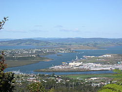
 Whangarei
Coordinates: 35°43′S 174°18′E / 35.717°S 174.3°ECoordinates: 35°43′S 174°18′E / 35.717°S 174.3°E Country New Zealand Region Northland Territorial Authority Whangarei District Pre 1989 Whangarei County Government - Mayor Morris Cutforth Population (June 2010 estimate)[1] - Urban 51,900 Whangarei, pronounced [ˈfaːŋaˌɾei], is the northernmost city in New Zealand and the regional capital of Northland Region. Although commonly classified as a city, it is officially part of the Whangarei District, administered by the Whangarei District Council a local body created in 1989 to administer both the city proper and its hinterland. The population was estimated to be 51,900 at the June 2010 estimate,[1] up from 47,400 in 2001.
The Whangarei urban area includes the suburbs of Kamo, Tikipunga, Otangarei, Mairtown, Riverside, Sherwood Rise, Onerahi, Morningside, Raumanga, Parihaka, Maunu, Horahora, Woodhill, Vinetown, The Regent, Kensington, and Whau Valley.
Contents
History
Captain James Cook and the crew of the Endeavour were the first Europeans to contemplate the Whangarei Harbour entrance. On 15 November 1769 they caught about one hundred fish there which they classified as 'bream' (probably snapper[disambiguation needed
 ]) prompting Cook to name the area Bream Bay.[2]
The Māori iwi Ngāpuhi occupied Whangarei from the early 19th century, and the Te Parawhau hapū lived at the head of the harbour. In the 1820s the area was repeatedly attacked by Waikato and Ngāti Paoa raiders during the Musket Wars.[3]
The first European settler was William Carruth, a Scotsman and trader who arrived in 1839 and was joined, six years later, by Gilbert Mair and his family. For the most part, relations between the settlers and local Māori were friendly, but in February 1842, all settler farms were plundered in revenge for transgressions of tapu. In April 1845, during the Flagstaff War, all settlers fled from Whangarei.[4] Most of the original settlers never returned, but by the mid 1850s there were a number of farmers and orchardists in the area. From 1855, a small town developed, driven by the kauri gum trade. Today's 'Town Basin' on the Hātea River was the original port and early exports included kauri gum and native timber followed later by coal from Whau Valley, Kamo and Hikurangi. Coal from the Kiripaka field was exported via the Ngunguru River. By 1864, the nucleus of the present city was established.[5]
Fire bricks made from fire clay deposits near the Kamo mines supported a brick works over several decades. Good quality limestone was quarried at Hikurangi, Portland, and Limestone Island, and initially sold as agricultural lime and later combined with local coal to produce Portland cement at the settlement of Portland on the south side of the harbour. Local limestone is still used in cement manufacture but the coal is now imported from the West Coast of the South Island.
Whangarei was the most urbanised area in Northland towards the end of the 19th century, but grew slowly in the 20th century. The district slowly exhausted most of its natural resources but was sustained by agriculture, especially dairying. Shipping was the main transport link until the North Auckland railway line reached the town in 1925, and the road from Auckland was not suitable for travel in poor weather until 1934.[6] These terrestrial travel routes forced a rapid decline in coastal shipping but stimulated Whangarei to become the service centre for Northland. The population was 14,000 in 1945, but grew rapidly in the 1960s, incorporating Kamo and other outlying areas. In 1965, Whangarei was declared a city. Its population the following year was 31,000.[7]
The second half of the twentieth century brought the establishment and expansion of the oil refinery at Marsden Point on Bream Bay and the adjacent development of timber processing. A container port could follow, linked by rail to Auckland.[8]
Geography
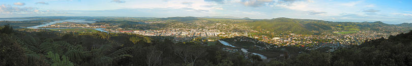 Panorama of Whangarei from Parihaka
Mount Parihaka
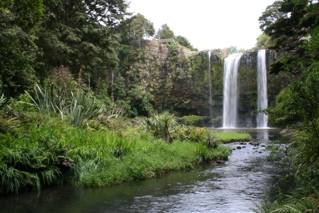
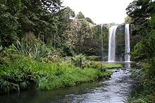 Whangarei Falls
Mt Parihaka is a volcanic dome rising 241 m to the northeast of the city centre. It is about 20 million years old, and part of the Harbour Fault which also includes Parakiore near Kamo, and Hikurangi near the town of the same name.[9] The dome is surrounded by the Parihaka Scenic Reserve. There is road access to the summit of Parihaka, and walking tracks through the reserve.[10]
The dome is frequently called Mount Parahaki, but the original Māori spelling of Parihaka was confirmed by the government in 2005.[11]
Hātea River
Main article: Hātea RiverThe Hātea River flows south through the city and empties into Whangarei Harbour. The river has a spectacular 26 m waterfall in Tikipunga, 6 km north of the city.[12]
Matakohe/Limestone Island
Main article: Motu MatakoheMatakoe, or Limestone Island, lies in the harbour close to the city. Owned by Whangarei District, it is subject to ecological island restoration by the Friends of Matakohe/Limestone Island Society. There is public access by boat.
Climate
Whangarei falls in the oceanic climate zone. It is the warmest and the northernmost city in NZ. Summer days occasionally exceed 30°C, and there is plentiful rainfall spread relatively evenly over the year.
Climate data for Whangarei Month Jan Feb Mar Apr May Jun Jul Aug Sep Oct Nov Dec Year Average high °C (°F) 24.4
(75.9)24.2
(75.6)23
(73)20.4
(68.7)18
(64)16
(61)15.1
(59.2)15.6
(60.1)16.8
(62.2)18.3
(64.9)20.6
(69.1)22.6
(72.7)19.6 Average low °C (°F) 15.4
(59.7)15.7
(60.3)15
(59)12.6
(54.7)10.1
(50.2)8.3
(46.9)7.2
(45.0)7.8
(46.0)9
(48)10.4
(50.7)12.2
(54.0)13.7
(56.7)11.4 Precipitation mm (inches) 90
(3.54)112
(4.41)142
(5.59)129
(5.08)120
(4.72)179
(7.05)151
(5.94)146
(5.75)130
(5.12)116
(4.57)80
(3.15)92
(3.62)1,490
(58.66)Source: NIWA Climate Data[13] Whangarei is roughly the antipodal point of Tangier, Morocco.
Sports
The Northland rugby league team are a rugby league team that represents the Northland Region in New Zealand Rugby League competitions. They are based in Whangarei. They currently compete in the Albert Baskerville Trophy as the Northern Swords. Between 2006 and 2007 they were part of the Bartercard Cup, playing under the name the Northern Storm. Northland was originally known as North Auckland and has previously used the nickname the Wild Boars.
Whangarei is home to the Northland rugby union team, a professional side competing in the ITM Cup, the highest level of provincial rugby in New Zealand. They play out of Okara Park, the largest stadium in the region, which is also hosting two matches during Rugby World Cup 2011.
The football (soccer) club North Force who compete in the Lotto Sport Italia NRFL Division 1 are based in Whangarei.
Whangarei also has an excellent Field Hockey facility, often hosting international matches between the New Zealand Black Sticks and various international opposition.
Northland is also represented at the highest national domestic level in Golf and Field Hockey. Northland has had reasonable success in field hockey of late, with several players from Northland being selected for the Black Sticks.
Education
Further information: List of schools in the Northland Region#WhangareiWhangarei Boys' High School is a boys' secondary school with a roll of 1060.[14] Whangarei Girls' High School is a girls' secondary school with a roll of 1127.[15] These two secondary schools have a decile rating of 5 and cover years 9-13. Both schools opened in 1881.[16][17]
Pompallier Catholic College (opened in 1971) is a Catholic state integrated co-educational secondary school (years 7 to 13) with a roll of 560 and a decile ranking of 7.
Whangarei Intermediate is an intermediate (years 7-8) school with a roll of 639.[18] Whangarei School is a contributing primary (years 1-6) school with a roll of 577.[19]Blomfield Special School and Resource Centre provides education and care to students between the ages of five and twenty-one years,[20] and has a roll of 68.[21] The school operates from five locations, four in Whangarei and one in Kaitaia.[22]
Christian Renewal School is a composite (years 1-15) school with a roll of 151.[23] The school was established in 1993 and integrated into the state system in 1997. The school operates in the Christian Renewal Church buildings.[24]
These four schools are all coeducational, and all have a decile rating of 4 except for the Christian Renewal School, which has a decile of 5.
Whangarei also has a technical institution, NorthTec, with a comprehensive range of programs from certificate to degree level. The student body of NorthTec consists of around 23,000 students studying either part-time and full-time. The main campus is located in the suburb of Raumanga.
Notable people
- Laurence Clark, cartoonist.[25]
- Keith Urban, country music singer
- Tim Southee, New Zealand cricketer
- Adam Blair, New Zealand Rugby League representative
- Michael Hill, jeweller
References
- ^ a b "Subnational population estimates at 30 June 2010 (boundaries at 1 November 2010)". Statistics New Zealand. 26 October 2010. http://www.stats.govt.nz/~/media/Statistics/Methods%20and%20Services/Tables/Subnational%20population%20estimates/subpopest2001-10.ashx. Retrieved 7 March 2011.
- ^ A. H. Reed (1968). Historic Northland.
- ^ Pickmere, Nancy Preece (1986). Whangarei: The Founding Years. pp. 1–6.
- ^ Pickmere, pp 20-46
- ^ Pickmere, pp 87-88
- ^ "Whāngārei City and environs". Te Ara Encyclopedia of New Zealand. http://www.teara.govt.nz/Places/Northland/NorthlandPlaces/15/en.
- ^ "Whangarei". Bateman New Zealand Encyclopedia (4th edition ed.). 1995. p. 632.
- ^ "Marsden Point - The Hype and The Reality". TelferYoung (Northland) Limited. June 2006. http://www.telferyoung.com/news/northland/ty1151288664.html.
- ^ Bruce Hayward, Mike Isaac, Keith Miller and Bernhard Spörli (2002). "Introduction to Whangarei geology" (PDF). Geological Society of New Zealand. p. 27. http://www.gsnz.org.nz/gs_downloads/fieldtrips/MP112B_FT4.pdf.
- ^ Parkes, W. F. (1992). Guide to Whangarei City and District. p. 7. ISBN 0-473-01639-7.
- ^ "Mount Parihaka name corrected". 19 July 2005. http://www.beehive.govt.nz/node/23727. Retrieved 2008-08-14.
- ^ Parkes, p 11
- ^ "Climate Data". NIWA. June 2011. http://www.niwascience.co.nz/edu/resources/climate/. Retrieved November 2, 2007.
- ^ "Te Kete Ipurangi - Whangarei Boys High School". Ministry of Education. http://www.tki.org.nz/e/schools/display_school_info.php?school_id=15.
- ^ "Te Kete Ipurangi - Whangarei Girls High School". Ministry of Education. http://www.tki.org.nz/e/schools/display_school_info.php?school_id=16.
- ^ "Whangarei Boys' High School -Our History". Whangarei Boys' High School. http://www.wbhs.school.nz/main.cfm?id=2558.
- ^ "Whangarei Girls' High". Whangarei Girls' High School. http://www.wghs.school.nz/.
- ^ "Te Kete Ipurangi - Whangarei Intermediate". Ministry of Education. http://www.tki.org.nz/e/schools/display_school_info.php?school_id=1129.
- ^ "Te Kete Ipurangi - Whangarei School". Ministry of Education. http://www.tki.org.nz/e/schools/display_school_info.php?school_id=1130.
- ^ "Education Review Report: Blomfield Special School and Resource Centre". Education Review Office. December 2007. http://www.ero.govt.nz/ERO\reppub.nsf/Institution/422D9D9A06EDBDFECC2573CD0011C5C8/$File/1007.htm.
- ^ "Te Kete Ipurangi - Blomfield Special School & Resource Centre". Ministry of Education. http://www.tki.org.nz/e/schools/display_school_info.php?school_id=1007.
- ^ "Blomfield Special School - locations". Blomfield Special School. http://www.blomfield.school.nz/school_page/locations.htm.
- ^ "Te Kete Ipurangi - Christian Renewal School". Ministry of Education. http://www.tki.org.nz/e/schools/display_school_info.php?school_id=1138.
- ^ "Supplementary Review Report: Christian Renewal School". Education Review Office. May 2005. http://www.ero.govt.nz/ERO\reppub.nsf/Institution/5479E079FDEDD817CC25701A0018D3EF/$File/1138.htm.
- ^ "Bio". http://www.klarc.co.nz/bio.html. Retrieved 2009-02-20.
External links
Categories:- Whangarei District
- Populated places in New Zealand


Wikimedia Foundation. 2010.