- Earthquakes in New Zealand
-
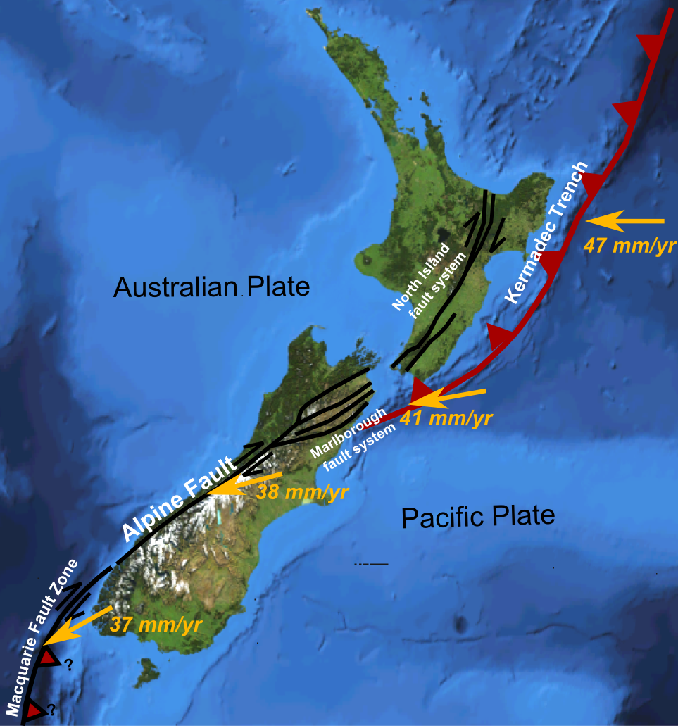
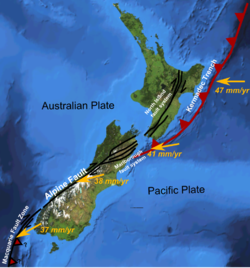 Major active fault zones of New Zealand showing variation in displacement vector of Pacific Plate relative to Australian Plate along the boundary
 Distribution of large earthquakes (magnitude 5 or greater)
Earthquakes in New Zealand occur as the country forms part of the Pacific Ring of Fire, which is geologically active. About 20,000 earthquakes, most of them minor, are recorded each year.[1] About 200 of these are strong enough to be felt.[2] As a result, New Zealand has very stringent building regulations.
Contents
Distribution
Most earthquakes in New Zealand occur along the main ranges running from Fiordland in the southwest to East Cape in the northeast. This axis follows the boundary between the Indo-Australian and Pacific plates. Large earthquakes are less common along the central Alpine Fault, where the plates are not subducting and the forces are accommodated in different ways.
The largest city within this high risk zone is the nation's capital, Wellington, followed by Hastings then Napier. All these cities have experienced severe earthquakes since European settlement.
Societal effects
New Zealand is sometimes nicknamed the Shaky Isles.[3] Quite early on, European settlers were faced with the reality of earthquakes in their new home. On 26 May 1840, the new settlement of Port Nicholson was struck by the first of a number of earthquakes and tremors.[4]
Public education
The New Zealand Earthquake Commission (EQC) provides public education to much of the country. As outlined in its statement of intent it hopes to provide "public education about seismic hazards and methods of reducing or preventing seismic disaster damage." The EQC sponsors exhibitions on seismic hazards in the Te Papa Museum of New Zealand, and is responsible for social marketing campaigns.[5] An extensive advertising campaign by the EQC across New Zealand's main television networks ran from June 2005 to June 2006. The adverts outlined the risks earthquakes pose to New Zealand and measures households can take to "Quake Safe their house." The slogan used throughout EQC Quake Safe campaigns is "Fix. Fasten. Forget."[6] Additionally in October 2006 many households received free "EQ-IQ" fridge magnets from the EQC.[7]
Building regulations
Early settlers learned fairly quickly the importance of using appropriate building methods in an earthquake-prone country. The 1848 earthquake, centred in Marlborough, caused great damage to the brick and masonry buildings in Wellington, and the city was rebuilt mainly in wood; consequently it suffered comparatively little damage in the 8.2 magnitude earthquake of 1855, which lifted the land 2–3m.[8]
Major earthquakes
Date Location Magnitude Fatalities Further information 08 Jul 1843 Wanganui 7.0 2 1843 Wanganui earthquake 16 Oct 1848 Marlborough 7.5 3 1848 Marlborough earthquake 23 Jan 1855 Wairarapa 8.1-8.3 9 1855 Wairarapa earthquake 23 Feb 1863 Hawke's Bay 7.5 Unknown 19 Oct 1868 Cape Farewell 7.5 Unknown 05 Jun 1869 Christchurch 5.2 0[9] 1869 Christchurch earthquake 01 Sep 1888 North Canterbury 7.1 0 1888 North Canterbury earthquake 12 Feb 1893 Nelson 6.9 Unknown 16 Nov 1901 Cheviot 6.9 1 1901 Cheviot earthquake 25 Dec 1922 Motunau 6.4 Unknown 09 Mar 1929 Arthur's Pass 7.1 Unknown 1929 Arthur's Pass earthquake 17 Jun 1929 Murchison 7.8 17 1929 Murchison earthquake 03 Feb 1931 Hawke's Bay 7.8 256 1931 Hawke's Bay earthquake 13 Feb 1931 Hawke's Bay 7.3 - Aftershock to 3 Feb 1931 05 Mar 1934 Pahiatua 7.6 2 24 Jun 1942 Wairarapa 7.2 0 02 Aug 1942 Wairarapa 7.0 1 26 Jun 1946 Lake Coleridge 6.2 0 24 May 1968 Inangahua Junction 7.1 2 15 Jan 1976 Kermadec Islands 8.2 0 21 Oct 1986 Kermadec Islands 8.3 0 02 Mar 1987 Edgecumbe 6.3 0 1987 Edgecumbe earthquake 24 May 1989 Puysegur Trench 8.2 0 13 May 1990 Weber 6.4[10] 0 18 Jun 1994 Arthur's Pass 6.7[11] 0 06 Feb 1995 East Cape 7.0 0 22 Aug 2003 Fiordland 7.1 0 22 Nov 2004 Puysegur Trench 7.2 0 24 Dec 2004 Puysegur Trench 8.1 0 15 Oct 2007 Arthur's Pass 6.8 0 20 Dec 2007 Gisborne 6.8 0 2007 Gisborne earthquake 30 Sep 2008 Kermadec Islands 7.0 0 10 Dec 2008 Kermadec Islands 6.8 0 Aftershock to 30 Sep 2008 15 Jul 2009 Fiordland 7.8 0 2009 Fiordland earthquake 04 Sep 2010 Darfield, Canterbury 7.1[12] 0 2010 Canterbury earthquake 29 Sep 2010 White Island 6.4 0 22 Feb 2011 Christchurch 6.3 182[13] February 2011 Christchurch earthquake 13 Jun 2011 Christchurch 6.3 1 June 2011 Christchurch earthquake 05 Jul 2011 Taupo 6.5 0 07 Jul 2011 Kermadec Islands 7.6 0 15 Sep 2011 North-east of New Zealand 6.0 0 22 Oct 2011 Kermadec Islands 7.4 0 See also
- List of New Zealand disasters by death toll
- Volcanism in New Zealand
- Canterbury Earthquake Response and Recovery Act 2010
References
- ^ Radio NZ news report on 2007 Gisborne earthquake
- ^ Earthquakes: The Short Story, Te Ara Encyclopedia of New Zealand
- ^ "New Zealand's land and environment"Ministry for the Environment
- ^ Dench, p 57
- ^ EQC Statement of Intent [1] EQC Statement of Intent
- ^ "EQC Annual Report 2006-2007"EQC Annual Report 2006-2007
- ^ "EQC Annual Report 2005-2006"EQC Annual Report 2005-2006
- ^ McSaveney, Eileen 'Earthquakes', Te Ara - the Encyclopedia of New Zealand, updated 21-Sep-2007
- ^ "Our Shaky History". Environment Canterbury. http://ecan.govt.nz/advice/emergencies-and-hazard/earthquakes/Documents/shaky_history.swf. Retrieved 21 October 2011.
- ^ "GeoNet - M6.4, Weber II, May 13, 1990". GeoNet. 13 May 1990. http://www.geonet.org.nz/earthquake/historic-earthquakes/more-nz/quake-09.html. Retrieved 5 September 2010.
- ^ http://www.informaworld.com/smpp/content~db=all~content=a920225718 informaworld.com
- ^ "New Zealand earthquake report - Sep 4 2010 at 4:35 am (NZST)". GeoNet. 4 September 2010. http://www.geonet.org.nz/earthquake/quakes/3366146g.html. Retrieved 4 September 2010.
- ^ "List of deceased - Christchurch earthquake". New Zealand Police. 3 May 2011. http://www.police.govt.nz/list-deceased. Retrieved 31 May 2011.
Further reading
- Dench, Alison (2005); Essential Dates: A Timeline of New Zealand History (Auckland, Random House) ISBN 1869416899
- Eiby, G. A. (1957); Earthquakes (London, Frederick Muller) Page 159 has Table of (16) Major Earthquakes in New Zealand 1848-1942, from R. C. Hayes.
- Henderson, J (1937); The West Nelson Earthquakes of 1929, Bulletin No. 55 of Department of Scientific and Industrial Research (Wellington, Government Printer)
External links
- Geonet: NZ's geological hazard monitoring system
- GNS Science: NZ Government research site
- Historic earthquakes in New Zealand
Seismic faults of New Zealand North Island North Island Fault System Wairarapa Fault · Wellington Fault
South Island Marlborough Fault System Awatere Fault · Clarence Fault · Hope Fault · Wairau Fault
Canterbury Fault System Christchurch Fault · Greendale Fault · Port Hills Fault
Other Categories:- Earthquakes in New Zealand
- Geographic areas of seismological interest
- Geology of New Zealand
- Lists of earthquakes by country
- New Zealand-related lists

Wikimedia Foundation. 2010.