- National Register of Historic Places listings in Windsor County, Vermont
-
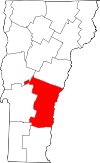 Location of Windsor County in Vermont
This is a list of the National Register of Historic Places listings in Windsor County, Vermont.
This is intended to be a complete list of the properties and districts on the National Register of Historic Places in Windsor County, Vermont, United States. Latitude and longitude coordinates are provided for many National Register properties and districts; these locations may be seen together in a Google map.[1]
There are 111 properties and districts listed on the National Register in the county.
-
- This National Park Service list is complete through NPS recent listings posted November 10, 2011.[2]
Contents: Counties in Vermont Addison - Bennington - Caledonia - Chittenden - Essex - Franklin - Grand Isle - Lamoille - Orange - Orleans - Rutland - Washington - Windham - Windsor Current listings
[3] Landmark name [4] Image Date listed Location City or town Summary 1 Aiken Stand Complex January 27, 1983 East of Bernard off Vermont Route 12
43°43′57″N 72°35′26″W / 43.7325°N 72.590556°WBarnard 2 Ascutney Mill Dam Historic District January 9, 2007 55 and 57 Ascutney St.
43°28′45″N 72°23′44″W / 43.479167°N 72.395556°WWindsor 3 Ascutney State Park 
June 14, 2002 1826 Back Mountain Rd.
43°26′34″N 72°26′08″W / 43.442778°N 72.435556°WWindsor 4 Atherton Farmstead March 1, 2002 31 Greenbush Rd.
43°24′52″N 72°32′49″W / 43.414444°N 72.546944°WCavendish 5 Beaver Meadow Union Chapel March 9, 1995 Northern side of Vermont Route 132
43°45′52″N 72°22′27″W / 43.764444°N 72.374167°WNorwich 6 Best's Covered Bridge July 2, 1973 About 8 mi (13 km) west of Windsor off Vermont Route 44
43°27′19″N 72°30′58″W / 43.455278°N 72.516111°WWindsor 7 Bethel Village Historic District September 3, 1976 Both sides of S. Main, Main, N. Main, and Church Sts.; also Vermont Route 107 across the White River and north to the Central Vermont Railway tracks
43°49′51″N 72°38′02″W / 43.830833°N 72.633889°WBethel Vermont Route 107 addresses represent a boundary increase 8 Black River Academy 
November 15, 1972 High St.
43°23′47″N 72°41′45″W / 43.396389°N 72.695833°WLudlow 9 Bowers Covered Bridge August 28, 1973 West of Windsor
43°27′42″N 72°29′29″W / 43.461667°N 72.491389°WWindsor Washed off abutments by Hurricane Irene but remains largely intact on bank downstream. 10 Theron Boyd Homestead May 20, 1993 Town Highway 6
43°37′52″N 72°27′50″W / 43.631111°N 72.463889°WHartford 11 Bridge 15 August 19, 2008 F.A.S. Highway 177 Sharon 12 Bridgewater Corners Bridge October 29, 1992 Vermont Route 100A over the Ottauquechee River
43°35′12″N 72°39′25″W / 43.586667°N 72.656944°WBridgewater 13 Bridgewater Woolen Mill July 6, 1976 U.S. Route 4
43°35′13″N 72°37′16″W / 43.586944°N 72.621111°WBridgewater 14 Brook Farm July 22, 1993 Twenty Mile Stream Rd. northwest of Cavendish
43°26′30″N 72°39′20″W / 43.441667°N 72.655556°WCavendish 15 Twing Buckman House April 4, 1996 U.S. Route 5, approximately 0.25 miles north of Chase Island
43°28′14″N 72°23′26″W / 43.470556°N 72.390556°WWindsor 16 Cavendish Universalist Church April 24, 1973 Vermont Route 131
43°23′05″N 72°36′22″W / 43.384722°N 72.606111°WCavendish 17 Chester Village Historic District August 8, 1985 Roughly bounded by Lovers Lane Brook, Maple St., the Williams River, Middle Branch, and Lovers Lane
43°15′54″N 72°36′04″W / 43.265°N 72.601111°WChester 18 Christian Street Rural Historic District December 5, 2003 Christian St., Hemlock Ridge Dr., and Jericho St.
43°57′30″N 72°18′19″W / 43.958333°N 72.305278°WHartford 19 Congregational Church of Ludlow January 28, 2004 48 Pleasant St.
43°23′49″N 72°41′50″W / 43.396944°N 72.697222°WLudlow 20 Coolidge State Park March 29, 2002 855 Coolidge State Park Rd.
43°33′08″N 72°41′39″W / 43.552222°N 72.694167°WPlymouth 21 Calvin Coolidge Homestead District 
October 15, 1966 Off Vermont Route 100A
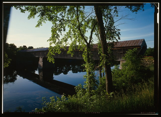
43°32′14″N 72°43′28″W / 43.537222°N 72.724444°WPlymouth Notch President Calvin Coolidge's birthplace and family home. 22 Cornish-Windsor Covered Bridge 
November 21, 1976 West of Cornish City
43°28′26″N 72°23′01″W / 43.473889°N 72.383611°WWindsor Extends into Cornish in Sullivan County, New Hampshire 23 Rev. George Daman House June 22, 1989 Wyman Ln.
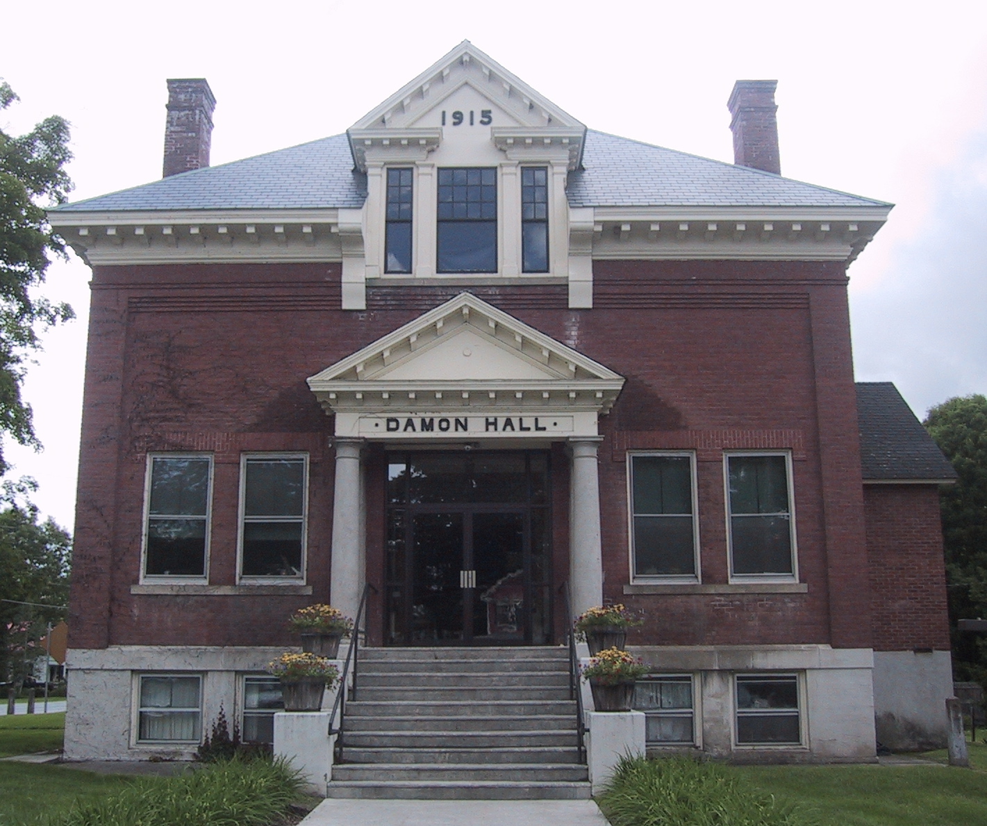
43°36′29″N 72°33′42″W / 43.608056°N 72.561667°WWoodstock 24 Damon Hall 
June 2, 1988 U.S. Route 5 and Vermont Route 12
43°32′29″N 72°24′01″W / 43.541389°N 72.400278°WHartland 25 Dewey House August 27, 1999 173 Deweys Mills Rd.
43°38′30″N 72°24′19″W / 43.641667°N 72.405278°WHartford 26 Ezekiel Emerson Farm November 29, 2001 Vermont Route 73
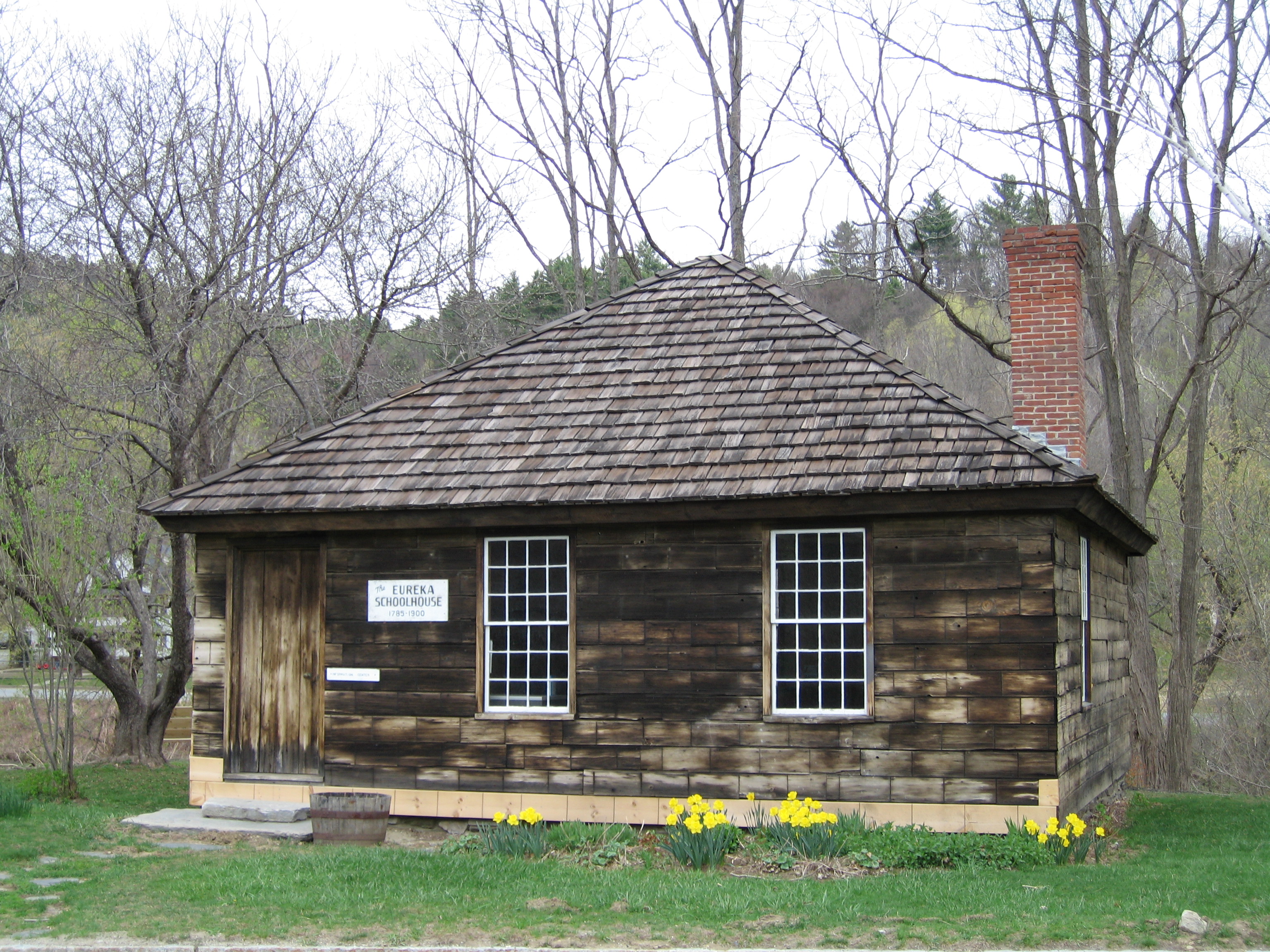
43°51′23″N 72°49′21″W / 43.856389°N 72.8225°WRochester 27 Eureka Schoolhouse 
March 11, 1971 Carleston Rd.
43°16′13″N 72°27′08″W / 43.270278°N 72.452222°WGoulds Mill 28 Joseph Fessenden House September 6, 2002 58 Bridge St.
43°48′54″N 72°32′50″W / 43.815°N 72.547222°WRoyalton 29 Fletcher-Fullerton Farm November 4, 2004 3615 Fletcher Hill Rd. Extension
43°34′08″N 72°33′35″W / 43.568889°N 72.559722°WWoodstock 30 Fowler-Steele House June 17, 1982 N. Main St.
43°29′24″N 72°23′10″W / 43.49°N 72.386111°WWindsor 31 Gate of the Hills November 18, 1991 Junction of North and Royalton Hill Rds.
43°49′15″N 72°37′50″W / 43.820833°N 72.630556°WBethel 32 Daniel Gay House January 9, 1978 Vermont Route 107
43°47′17″N 72°41′53″W / 43.788056°N 72.698056°WGaysville 33 Gilead Brook Bridge October 11, 1990 Vermont Route 12 over Gilead Brook
43°52′25″N 72°38′52″W / 43.873611°N 72.647778°WBethel 34 Glimmerstone November 14, 1978 Vermont Route 131
43°22′58″N 72°36′48″W / 43.382778°N 72.613333°WCavendish 35 Gould's Mill Bridge February 1, 2006 Vermont Route 66, Paddock Rd. over the Black River
43°16′22″N 72°27′16″W / 43.272778°N 72.454444°WSpringfield 36 Greenwood House October 31, 1985 Vermont Route 103
43°15′28″N 72°35′14″W / 43.257778°N 72.587222°WChester 37 Harrington House March 16, 1983 River St. and Vermont Route 107
43°49′17″N 72°37′56″W / 43.821389°N 72.632222°WBethel 38 Hartford Library December 9, 1994 217 Main St.
43°39′41″N 72°20′35″W / 43.661389°N 72.343056°WHartford 39 Hartford Village Historic District September 3, 1998 Roughly along Hartford Main, Summer and Christian Sts.
43°39′45″N 72°20′23″W / 43.6625°N 72.339722°WHartford 40 Hartness House December 20, 1978 30 Orchard St.
43°18′16″N 72°28′34″W / 43.304444°N 72.476111°WSpringfield 41 Historic Crown Point Road December 2, 1974 Off Vermont Route 131
43°23′29″N 72°30′12″W / 43.391389°N 72.503333°WWeathersfield 42 Indian Stones November 20, 1974 Vermont Route 106
43°26′47″N 72°32′07″W / 43.446389°N 72.535278°WReading 43 Iron Bridge at Howard Hill Road September 9, 1982 Howard Hill Rd. and Vermont Route 131
43°24′16″N 72°34′32″W / 43.404444°N 72.575556°WCavendish 44 Jeffrey House June 13, 1974 North St.
43°16′13″N 72°35′54″W / 43.270278°N 72.598333°WChester 45 Jericho Rural Historic District November 8, 2001 Jericho St., Jericho Rd., Wallace Rd., Sugartop Rd., Joshua Rd.
43°42′17″N 72°22′32″W / 43.704722°N 72.375556°WHartford 46 Wales N. Johnson House November 7, 1995 37 U.S. Route 4
43°36′44″N 72°33′00″W / 43.612222°N 72.55°WWoodstock 47 Juniper Hill Farm-Maxwell Evarts House July 14, 1988 Juniper Hill Rd.
43°29′31″N 72°23′45″W / 43.491944°N 72.395833°WWindsor 48 Kendron Brook Bridge August 27, 1992 Town Highway 65 over Kendron Brook
43°34′53″N 72°30′55″W / 43.581389°N 72.515278°WWoodstock 49 The King Farm January 31, 1997 King Farm Rd., 0.5 miles north of its junction with U.S. Route 4
43°37′23″N 72°32′41″W / 43.623056°N 72.544722°WWoodstock 50 Lincoln Covered Bridge August 28, 1973 Southwest of Woodstock off U.S. Route 4
43°36′02″N 72°34′10″W / 43.600556°N 72.569444°WWoodstock 51 Lockwood-Boynton House May 4, 1982 1 School St.
43°19′59″N 72°31′36″W / 43.333056°N 72.526667°WNorth Springfield 52 Locust Creek House Complex December 10, 1982 Vermont Route 12
43°48′32″N 72°39′04″W / 43.808889°N 72.651111°WBethel 53 Ludlow Graded School November 29, 1979 High St.
43°23′48″N 72°41′52″W / 43.396667°N 72.697778°WLudlow 54 Ludlow Village Historic District January 9, 2007 Main St., Depot St.
43°23′53″N 72°41′59″W / 43.398056°N 72.699722°WLudlow 55 Charles Marsh Law Office December 9, 1994 72 Pleasant St.
43°37′36″N 72°30′23″W / 43.626667°N 72.506389°WWoodstock 56 George Perkins Marsh Boyhood Home June 11, 1967 54 Elm St.
43°37′51″N 72°31′11″W / 43.630833°N 72.519722°WWoodstock Boyhood home of George Perkins Marsh, an American diplomat and philologist, an early environmentalist. 57 Joseph and Daniel Marsh House September 3, 1998 64 Dewey's Mill Rd.
43°38′55″N 72°23′51″W / 43.64861°N 72.3975°WHartford 58 Marsh-Billings-Rockefeller National Historical Park 
August 26, 1992 P.O. Box 178
43°38′00″N 72°31′16″W / 43.633333°N 72.521111°WWoodstock 59 Martin's Mill Covered Bridge August 28, 1973 South of Hartland off U.S. Route 5
43°31′56″N 72°23′47″W / 43.532222°N 72.396389°WHartland 60 McKenstry Manor December 1, 1978 North of Bethel on Vermont Route 12
43°52′00″N 72°39′11″W / 43.866667°N 72.653056°WBethel 61 Owen Moon Farm January 27, 1983 South of South Woodstock off Vermont Route 106
43°33′18″N 72°31′59″W / 43.555°N 72.533056°WSouth Woodstock 62 Gen. Lewis R. Morris House June 25, 1992 456 Old Connecticut River Rd.
43°17′23″N 72°24′37″W / 43.289722°N 72.410278°WSpringfield 63 NAMCO Block November 14, 1991 1-17 Union St.
43°28′32″N 72°23′23″W / 43.475556°N 72.389722°WWindsor 64 Norwich Village Historic District 
January 3, 1991 Main St. from south of Elm St. to Turnpike Rd. and adjacent portions of Elm, Church, Mechanic, Hazen and Cliff Sts.
43°42′56″N 72°18′38″W / 43.715556°N 72.310556°WNorwich 65 Old Christ Church March 6, 2008 Junction of Vermont Route 12 and Gilead Brook Rd.
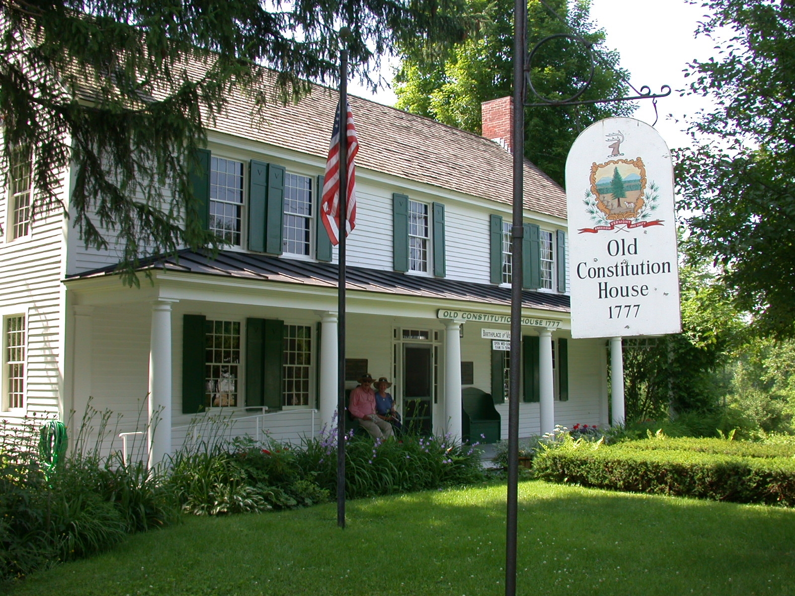
43°52′30″N 72°38′51″W / 43.875°N 72.6475°WBethel 66 Old Constitution House 
March 11, 1971 16 N. Main St.
43°29′03″N 72°23′08″W / 43.484167°N 72.385556°WWindsor 67 Ottauquechee River Bridge October 11, 1990 U.S. Route 5 over the Ottauquechee River
43°36′09″N 72°21′17″W / 43.6025°N 72.354722°WHartland 68 Parker Hill Rural Historic District May 20, 1993 Parker Hill and Lower Parker Hill Rds.
43°13′25″N 72°28′46″W / 43.223611°N 72.479444°WSpringfield 69 Plymouth Historic District December 12, 1970 Vermont Route 100A
43°32′30″N 72°42′51″W / 43.541667°N 72.714167°WPlymouth 70 Pollard Block August 28, 2008 7 Depot St.
43°22′57″N 72°38′18″W / 43.382533°N 72.638342°WCavendish 71 Progressive Market July 10, 1995 63 S. Main St.
43°38′46″N 72°19′09″W / 43.646111°N 72.319167°WHartford 72 Quechee Gorge Bridge October 11, 1990 U.S. Route 4 over Quechee Gorge
43°38′16″N 72°24′32″W / 43.637778°N 72.408889°WHartford 73 Quechee Historic Mill District July 3, 1997 Roughly along High, Quechee Main, River, and School Sts., and River, Waterman Hill, Deweys Mill, and Cemetery Rds.
43°38′50″N 72°25′07″W / 43.647222°N 72.418611°WHartford 74 Isaac M. Raymond Farm April 1, 1993 Junction of Woodstock Town Highways 95 and 18
43°39′29″N 72°34′04″W / 43.658056°N 72.567778°WWoodstock 75 Reading Town Hall March 7, 1996 Junction of Vermont Route 106 and Pleasant St.
43°27′20″N 72°32′16″W / 43.455556°N 72.537778°WReading 76 Robbins and Lawrence Armory and Machine Shop November 13, 1966 S. Main St.
43°28′29″N 72°23′23″W / 43.474722°N 72.389722°WWindsor Erected in 1846, an excellent example of 19th century American industrial architecture. 77 Royalton Mill Complex February 3, 1983 North of South Royalton on Town Rd. 12
43°49′54″N 72°30′56″W / 43.831667°N 72.515556°WSouth Royalton 78 Saddlebow Farm November 14, 2002 2477 Gold Coast Rd.
43°36′54″N 72°37′19″W / 43.615°N 72.621944°WBridgewater 79 Simons' Inn March 2, 1979 Southwest of Andover on Vermont Route 11
43°15′28″N 72°43′01″W / 43.257778°N 72.716944°WAndover 80 Slayton-Morgan Historic District June 24, 2010 Address Restricted Woodstock 81 South Reading Schoolhouse February 3, 1983 Felchville-Tyson's Corner Rd.
43°28′34″N 72°35′41″W / 43.476111°N 72.594722°WSouth Reading 82 South Royalton Historic District September 3, 1976 East of Royalton on Vermont Route 14
43°49′17″N 72°31′15″W / 43.821389°N 72.520833°WRoyalton 83 South Woodstock Village Historic District August 12, 1982 Both sides of Vermont Route 106, Town Highway 61, and Church Hill Rd.
43°33′48″N 72°31′57″W / 43.563333°N 72.5325°WWoodstock 84 Southview Housing Historic District November 8, 2007 1-107 Stanley Rd.
43°17′06″N 72°28′35″W / 43.285°N 72.476389°WSpringfield 85 Spaulding Bridge January 11, 2006 Mill St.
43°22′57″N 72°36′31″W / 43.3825°N 72.608611°WCavendish 86 Zachariah Spaulding Farm November 4, 1993 Town Highway 38 south of the Ludlow town center
43°22′53″N 72°41′29″W / 43.381389°N 72.691389°WLudlow 87 Springfield Downtown Historic District August 11, 1983 Roughly bounded by the Black River and Mineral, Pearl, Main, and Valley Sts.; also roughly the Brookline Apartments on Wall St., Park St., and along the Black River
43°18′04″N 72°29′05″W / 43.301111°N 72.484722°WSpringfield Brookline Apartments represent a boundary increase 88 St. Pauls's Episcopal Church March 2, 2001 Junction of Bridge St. and Vermont Route 14
43°48′55″N 72°32′48″W / 43.815278°N 72.546667°WRoyalton 89 Stellafane Observatory November 7, 1977 South of North Springfield off Breezy Hill Rd.
43°16′41″N 72°31′10″W / 43.278056°N 72.519444°WNorth Springfield Contains original clubhouse of the Springfield Telescope Makers, Inc. (1924), and the first large optical telescope (1930) built and owned by that kind of amateur society. 90 Stockbridge Common Historic District May 24, 1990 Area around Stockbridge Common, including Maplewood Cemetery
43°47′12″N 72°45′19″W / 43.786667°N 72.755278°WStockbridge 91 Stockbridge Four Corners Bridge November 14, 1991 Vermont Route 100 over the White River
43°46′56″N 72°45′30″W / 43.782222°N 72.758333°WStockbridge 92 Stone Village Historic District 
May 17, 1974 Both sides of Vermont Route 103
43°16′24″N 72°35′35″W / 43.273333°N 72.593056°WChester 93 Jedediah Strong II House August 13, 1974 Clubhouse and Dewey's Mills Rds.
43°38′44″N 72°24′02″W / 43.645556°N 72.400556°WHartford 94 David Sumner House March 2, 1989 U.S. Route 5
43°32′24″N 72°23′56″W / 43.54°N 72.398889°WHartland 95 Taftsville Covered Bridge 
August 28, 1973 East of Woodstock off U.S. Route 4
43°38′23″N 72°28′05″W / 43.639722°N 72.468056°WWoodstock 96 Taftsville Historic District August 2, 2001 Portions of U.S. Route 4, Upper River Rd., Quechee Main St., all Butternut Ln., Happy Valley Rd., Sugar Hill Rd.
43°37′46″N 72°28′26″W / 43.629444°N 72.473889°WHartford 97 Upper Falls Covered Bridge August 28, 1973 North of Perkinsville off Vermont Route 131
43°23′55″N 72°31′21″W / 43.398611°N 72.5225°WPerkinsville 98 Weathersfield Center Historic District June 30, 1980 Center Rd.
43°22′43″N 72°28′05″W / 43.378611°N 72.468056°WWeathersfield Center 99 West Hartford Bridge October 29, 1992 Town Highway 14 at Vermont Route 14 over the White River
43°42′44″N 72°25′06″W / 43.712222°N 72.418333°WHartford 100 West Hartford Village Historic District December 15, 2004 Vermont Route 14, Harper Savage Ln., Tigertown Rd., and Stetson Rd.
43°42′59″N 72°24′58″W / 43.716389°N 72.416111°WHartford 101 West Woodstock Bridge August 27, 1992 Town Highway 50 over the Ottauquechee River
43°36′51″N 72°32′36″W / 43.614167°N 72.543333°WWest Woodstock 102 Weston Village Historic District August 29, 1985 Main, Park, and School Sts., Lawrence Hill, Landgrove, and Trout Club Rds., Mill Lane, and Chester Mountain Rd.
43°17′30″N 72°47′40″W / 43.291667°N 72.794444°WWeston 103 White River Junction Historic District 
August 22, 1980 Railroad Row, Main, Currier, Bridge, and Gates Sts.; also N. Main St., S. Main St. Bridge St., Gates St., and Church St.
43°38′53″N 72°19′09″W / 43.648056°N 72.319167°WHartford Second set of addresses represents a boundary increase 104 Wilder Village Historic District November 22, 1999 Portions of Norwich, Passumpsic, and Horseshoe Aves., Chestnut, Gillette, Fern, Hawthorn, Locust and Division Sts.
43°40′30″N 72°18′31″W / 43.675°N 72.308611°WHartford 105 John Wilder House November 10, 1983 Lawrence Hill Rd.
43°17′32″N 72°47′43″W / 43.292222°N 72.795278°WWeston 106 Wilgus State Park March 29, 2002 3985 U.S. Route 5
43°23′27″N 72°24′38″W / 43.390833°N 72.410556°WWeathersfield 107 Willard Covered Bridge August 28, 1973 Northeast of Hartland off U.S. Route 5
43°35′37″N 72°21′01″W / 43.593611°N 72.350278°WHartland 108 Windsor House December 29, 1971 N. Main St., north of the junction of Main and State Sts.
43°28′56″N 72°23′11″W / 43.482222°N 72.386389°WWindsor 109 Windsor Village Historic District April 23, 1975 Area centered around Main, Depot Ave., State St., and Court Sq.; also along Phelps Ct. and State St.
43°28′50″N 72°23′13″W / 43.480556°N 72.386944°WWindsor Second set of addresses represents a boundary increase 110 Woodstock Village Historic District January 22, 1973 Along the Ottauquechee River
43°37′33″N 72°30′59″W / 43.625833°N 72.516389°WWoodstock 111 Woodstock Warren Through Truss Bridge August 18, 1992 Town Highway 24 across the Ottauquechee River
43°36′01″N 72°35′22″W / 43.600278°N 72.589444°WWoodstock See also
- List of National Historic Landmarks in Vermont
- National Register of Historic Places listings in Vermont
References
- ^ The latitude and longitude information provided in this table was derived originally from the National Register Information System, which has been found to be fairly accurate for about 99% of listings. For about 1% of NRIS original coordinates, experience has shown that one or both coordinates are typos or otherwise extremely far off; some corrections may have been made. A more subtle problem causes many locations to be off by up to 150 yards, depending on location in the country: most NRIS coordinates were derived from tracing out latitude and longitudes off of USGS topographical quadrant maps created under North American Datum of 1927, which differs from the current, highly accurate GPS system used by Google maps. Chicago is about right, but NRIS longitudes in Washington are higher by about 4.5 seconds, and are lower by about 2.0 seconds in Maine. Latitudes differ by about 1.0 second in Florida. Some locations in this table may have been corrected to current GPS standards.
- ^ "National Register of Historic Places: Weekly List Actions". National Park Service, United States Department of the Interior. Retrieved on November 10, 2011.
- ^ Numbers represent an ordering by significant words. Various colorings, defined here, differentiate National Historic Landmark sites and National Register of Historic Places Districts from other NRHP buildings, structures, sites or objects.
- ^ "National Register Information System". National Register of Historic Places. National Park Service. . http://nrhp.focus.nps.gov/natreg/docs/All_Data.html.
U.S. National Register of Historic Places Topics Lists by states Alabama • Alaska • Arizona • Arkansas • California • Colorado • Connecticut • Delaware • Florida • Georgia • Hawaii • Idaho • Illinois • Indiana • Iowa • Kansas • Kentucky • Louisiana • Maine • Maryland • Massachusetts • Michigan • Minnesota • Mississippi • Missouri • Montana • Nebraska • Nevada • New Hampshire • New Jersey • New Mexico • New York • North Carolina • North Dakota • Ohio • Oklahoma • Oregon • Pennsylvania • Rhode Island • South Carolina • South Dakota • Tennessee • Texas • Utah • Vermont • Virginia • Washington • West Virginia • Wisconsin • WyomingLists by territories Lists by associated states Other Municipalities and communities of Windsor County, Vermont Towns Andover | Baltimore | Barnard | Bethel | Bridgewater | Cavendish | Chester | Hartford | Hartland | Ludlow | Norwich | Plymouth | Pomfret | Reading | Rochester | Royalton | Sharon | Springfield | Stockbridge | Weathersfield | West Windsor | Weston | Windsor | Woodstock

Villages CDPs Other
communitiesBrownsville | Hartford | Lewiston | Plymouth Notch | South Woodstock | Weathersfield Bow | West Hartford
Categories:- National Register of Historic Places in Vermont by county
- Windsor County, Vermont
-


Wikimedia Foundation. 2010.