- National Register of Historic Places listings in Caledonia County, Vermont
-
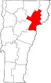 Location of Caledonia County in Vermont
This is a list of the National Register of Historic Places listings in Caledonia County, Vermont.
This is intended to be a complete list of the properties and districts on the National Register of Historic Places in Caledonia County, Vermont, United States. Latitude and longitude coordinates are provided for many National Register properties and districts; these locations may be seen together in a Google map.[1]
There are 55 properties and districts listed on the National Register in the county, including 1 National Historic Landmark.
-
- This National Park Service list is complete through NPS recent listings posted November 10, 2011.[2]
Contents: Counties in Vermont Addison - Bennington - Caledonia - Chittenden - Essex - Franklin - Grand Isle - Lamoille - Orange - Orleans - Rutland - Washington - Windham - Windsor Current listings
[3] Landmark name [4] Image Date listed Location City or town Summary 1 Barnet Center Historic DIstrict July 12, 1984 Off U.S. Route 5
44°18′44″N 72°05′09″W / 44.312222°N 72.085833°WBarnet 2 Benoit Apartment House-74 Pearl Street May 6, 1994 74 Pearl St.
44°25′11″N 72°01′02″W / 44.419722°N 72.017222°WSt. Johnsbury 3 Benoit Apartment House-76 Pearl Street May 6, 1994 76 Pearl St.
44°25′09″N 72°01′02″W / 44.419167°N 72.017222°WSt. Johnsbury 4 Bradley Covered Bridge June 13, 1977 North of Lyndon on VT 122 over Miller Run
44°32′31″N 72°00′38″W / 44.541944°N 72.010556°WLyndon 5 Building at 143 Highland Avenue April 6, 2000 143 Highland Ave.
44°30′22″N 72°22′07″W / 44.506111°N 72.368611°WHardwick 6 Burklyn Hall May 7, 1973 Bemis Hill Rd.
44°35′04″N 71°57′49″W / 44.584444°N 71.963611°WEast Burke 7 Burrington Covered Bridge June 13, 1974 Northeast of Lyndon off VT 114 over the East Branch of the Passumpsic River
44°33′13″N 71°58′12″W / 44.553611°N 71.97°WLyndon 8 Centre Covered Bridge June 20, 1974 Northeast of Lyndon off U.S. Route 5, over the Passumpsic River
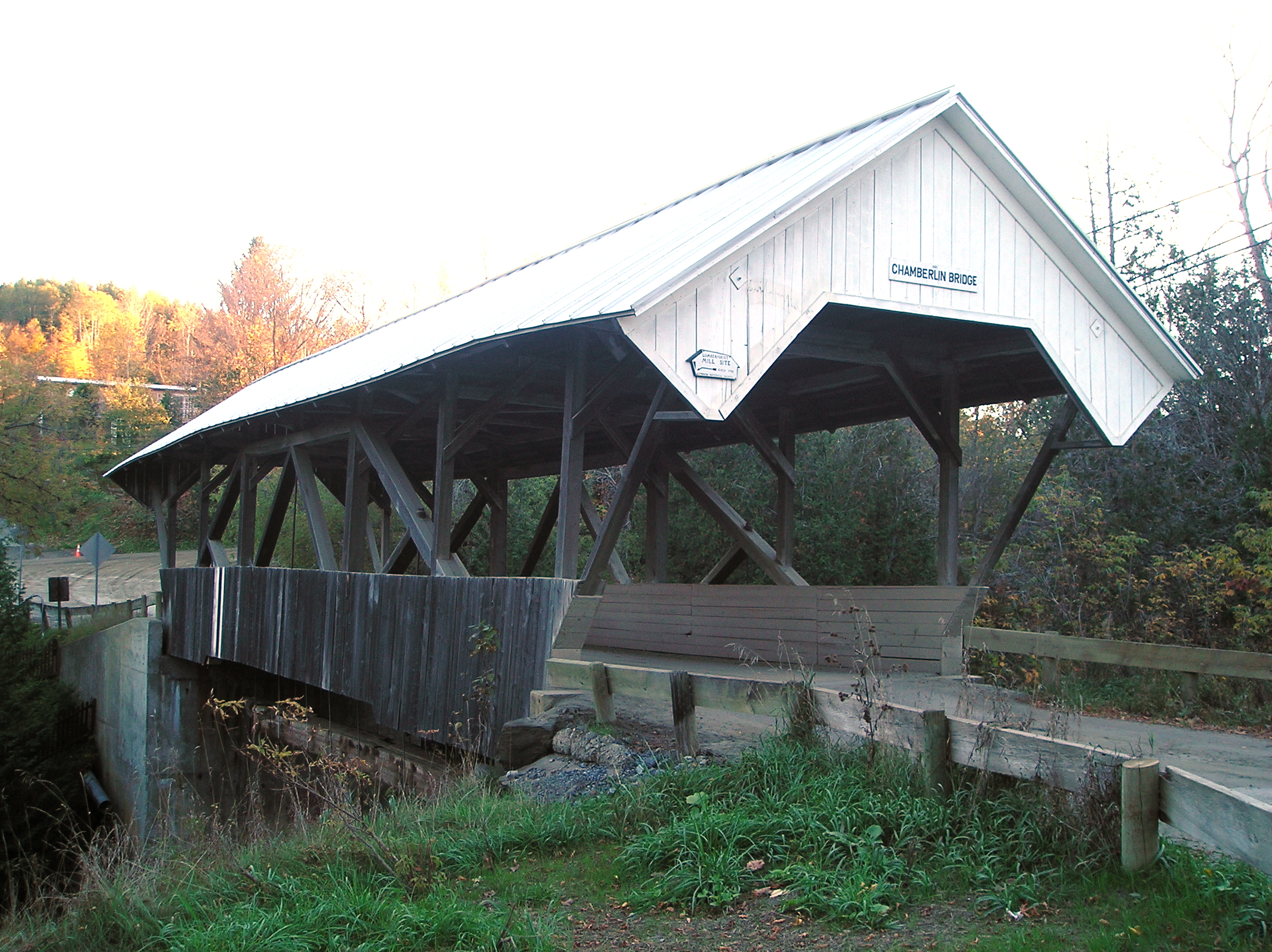
44°32′36″N 72°00′06″W / 44.543333°N 72.001667°WLyndon 9 Chamberlin Mill Covered Bridge 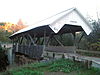
July 30, 1974 West of VT 114 over the South Wheelock Branch of Passumpsic River
44°30′59″N 72°01′00″W / 44.516389°N 72.016667°WLyndon 10 Christian Union Society Meetinghouse May 23, 1980 Bayley-Hazen Military Rd.
44°28′43″N 72°17′30″W / 44.478611°N 72.291667°WSouth Walden 11 Cobb School September 30, 1993 Junction of Hardwick Town Highway 10 (Cobb School Rd.) and Sanborn Cemetery Rd.
44°33′23″N 72°20′32″W / 44.556389°N 72.342222°WHardwick 12 Cote Apartment House May 6, 1994 16 Elm St.
44°25′18″N 72°00′40″W / 44.421667°N 72.011111°WSt. Johnsbury 13 Darling Estate Historic District August 23, 2011 Darling Hill Rd. in Burke and Lyndon; Pinkham Rd. in Burke
44°35′24″N 71°57′37″W / 44.59°N 71.96028°W[5]Burke 14 Darling Inn November 24, 1980 Depot St.
44°32′03″N 72°00′16″W / 44.534167°N 72.004444°WLyndonville 15 J. R. Darling Store May 12, 2004 284 Scott Highway
44°12′44″N 72°11′41″W / 44.212222°N 72.194722°WGroton 16 District 6 School House February 1, 2006 73 Cemetery Circle
44°32′27″N 72°00′44″W / 44.540833°N 72.012222°WLyndon 17 Downtown Hardwick Village Historic District 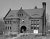
September 30, 1982 Main, Church, Maple, and Mill Sts.; also Brush St.
44°30′19″N 72°21′50″W / 44.505278°N 72.363889°WHardwick Brush St. represents a boundary increase 18 Elkins Tavern December 18, 1978 Bailey-Hazen Rd.
44°19′25″N 72°09′37″W / 44.323611°N 72.160278°WPeacham 19 Fairbanks Museum 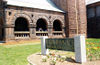
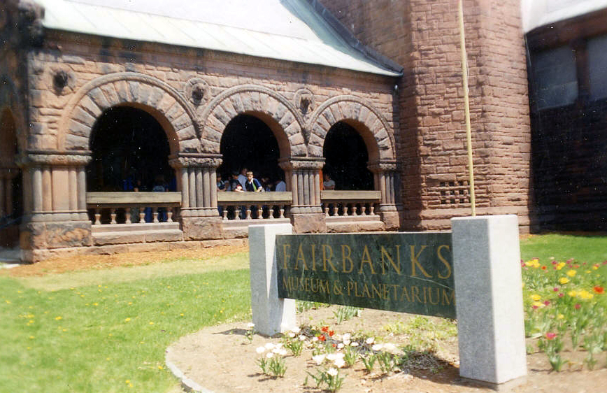
January 2, 2008 1302 Main St.
44°25′12″N 72°01′13″W / 44.42°N 72.020278°WSt. Johnsbury 20 Franklin Fairbanks House September 27, 1980 30 Western Ave.
44°25′02″N 72°01′39″W / 44.417222°N 72.0275°WSt. Johnsbury 21 William and Agnes Gilkerson Farm October 29, 1992 Town Highway 5 west of its junction with U.S. Route 5
44°21′44″N 72°03′41″W / 44.362222°N 72.061389°WBarnet 22 Alice Lord Goodine House May 12, 2004 276 Scott Highway
44°12′37″N 72°11′40″W / 44.210278°N 72.194444°WGroton 23 Greenbanks Hollow Covered Bridge June 13, 1974 South of Danville over Joes Brook
44°22′38″N 72°07′20″W / 44.377222°N 72.122222°WDanville 24 Grouselands December 22, 1983 Town Highway 26
44°29′38″N 72°07′14″W / 44.493889°N 72.120556°WDanville 25 Hardwick Street Historic District June 22, 1979 Northeast of Hardwick
44°33′00″N 72°17′58″W / 44.55°N 72.299444°WHardwick 26 Lee Farm May 26, 1983 VT 25
44°25′20″N 71°57′03″W / 44.422222°N 71.950833°WWaterford 27 Lind Houses September 27, 1988 Pleasant St.
44°11′07″N 72°08′19″W / 44.185278°N 72.138611°WSouth Ryegate 28 Maple Street-Clarks Avenue Historic District May 5, 1994 17-49 Maple St., 4-34 Clarks Ave., 95½-101 Main St., 4 and 6 Frost Ave., and 3 and 5 Idlewood Terr.
44°25′18″N 72°01′04″W / 44.421667°N 72.017778°WSt. Johnsbury 29 Caleb H. Marshall House August 16, 1994 53 Summer St.
44°25′17″N 72°01′18″W / 44.421389°N 72.021667°WSt. Johnsbury 30 Mathewson Block May 20, 1999 Junction of Main St. and Maple St.
44°32′07″N 72°00′21″W / 44.535278°N 72.005833°WLyndon 31 McIndoes Academy May 6, 1975 Main St.
44°15′51″N 72°03′52″W / 44.264167°N 72.064444°WMcIndoe Falls 32 Methodist-Episcopal Church January 5, 1978 Off VT 16
44°32′33″N 72°12′48″W / 44.5425°N 72.213333°WStannard 33 Morency Paint Shop and Apartment Building May 5, 1994 73-77 Portland St.
44°25′13″N 72°00′30″W / 44.420278°N 72.008333°WSt. Johnsbury 34 New Discovery State Park January 17, 2002 4239 VT 232
44°18′36″N 72°15′08″W / 44.31°N 72.252222°WPeacham 35 Old Schoolhouse Bridge March 31, 1971 S. Wheelock Rd. over Cold Hill Brook
44°30′57″N 72°00′38″W / 44.515833°N 72.010556°WLyndon 36 Peacham Corner Historic District December 18, 2003 Bayley Hazen Rd., Main St., Church St., Academy Hill, Old Cemetery Rd., Macks Mountain Rd.
44°19′39″N 72°10′21″W / 44.3275°N 72.1725°WPeacham 37 Railroad Street Historic District June 25, 1974 Roughly bounded north and south by Railroad St. and the Canadian Pacific railroad tracks
44°25′01″N 72°01′00″W / 44.416944°N 72.016667°WSt. Johnsbury 38 Ricker Pond State Park March 29, 2002 526 State Forest Rd.
44°14′41″N 72°14′54″W / 44.244722°N 72.248333°WGroton 39 Riverside June 17, 1993 Lily Pond Rd. south of Lyndonville
44°30′47″N 71°59′40″W / 44.513056°N 71.994444°WLyndonville 40 Shearer and Corser Double House August 16, 1994 81-83 Summer St.
44°25′25″N 72°01′13″W / 44.423611°N 72.020278°WSt. Johnsbury 41 Josiah and Lydia Shedd Farmstead March 17, 2005 1721 Bayley-Hazen Rd.
44°20′48″N 72°10′41″W / 44.346667°N 72.178056°WPeacham 42 St. Johnsbury Athenaeum 
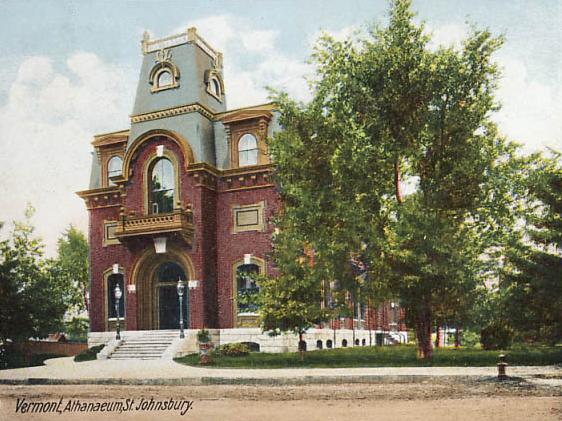
June 18, 1996 30 Main St.
44°25′04″N 72°01′19″W / 44.417778°N 72.021944°WSt. Johnsbury Significant due to its construction, its American paintings and books from its original role as a public library and free art gallery, and its funding by Horace Fairbanks, manufacturer of the world’s first platform scale. 43 St. Johnsbury Federal Fish Culture Station March 18, 2005 374 Emerxon Falls Rd.
44°26′10″N 72°02′17″W / 44.436111°N 72.038056°WSt. Johnsbury 44 St. Johnsbury Historic District April 17, 1980 U.S. Routes 2 and 5
44°25′06″N 72°01′02″W / 44.418333°N 72.017222°WSt. Johnsbury 45 St. Johnsbury Main Street Historic District May 28, 1975 Area along Main St. including intersecting streets
44°25′06″N 72°01′14″W / 44.418333°N 72.020556°WSt. Johnsbury 46 Stannard Schoolhouse December 12, 1977 Off VT 16
44°32′34″N 72°12′52″W / 44.542778°N 72.214444°WStannard 47 Stillwater State Park March 29, 2002 126 Boulder Beach Rd.
44°16′46″N 72°16′23″W / 44.279444°N 72.273056°WGroton 48 Thresher Mill 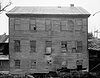
April 4, 1996 VT 1, approximately 1.5 mi (2.4 km) west of Barnet
44°18′37″N 72°05′51″W / 44.310278°N 72.0975°WBarnet 49 Phineas Thurston House October 30, 1989 Barnet Town Highway 12
44°21′56″N 72°01′29″W / 44.365556°N 72.024722°WBarnet 50 Toll House August 9, 2006 2028 Mountain Rd.
44°35′38″N 71°54′12″W / 44.593889°N 71.903333°WBurke 51 Union Meeting House January 4, 2008 2614 Burke Hollow Rd.
44°37′20″N 71°56′55″W / 44.622222°N 71.948611°WBurke 52 West View Farm January 6, 1995 Along Waterford Highway 34
44°24′08″N 71°59′33″W / 44.402222°N 71.9925°WWaterford 53 Wheelock Common Historic District August 30, 2007 VT 122 and Town Highway 17 Wheelock 54 Whitehill House May 30, 1975 North of Ryegate on Groton-Peacham Rd.
44°15′55″N 72°10′27″W / 44.265278°N 72.174167°WRyegate 55 Whittier House August 23, 1984 U.S. Route 2
44°22′43″N 72°07′22″W / 44.378611°N 72.122778°WDanville See also
- List of National Historic Landmarks in Vermont
- National Register of Historic Places listings in Vermont
References
- ^ The latitude and longitude information provided in this table was derived originally from the National Register Information System, which has been found to be fairly accurate for about 99% of listings. For about 1% of NRIS original coordinates, experience has shown that one or both coordinates are typos or otherwise extremely far off; some corrections may have been made. A more subtle problem causes many locations to be off by up to 150 yards, depending on location in the country: most NRIS coordinates were derived from tracing out latitude and longitudes off of USGS topographical quadrant maps created under the North American Datum of 1927, which differs from the current, highly accurate WGS84 GPS system used by Google maps. Chicago is about right, but NRIS longitudes in Washington are higher by about 4.5 seconds, and are lower by about 2.0 seconds in Maine. Latitudes differ by about 1.0 second in Florida. Some locations in this table may have been corrected to current GPS standards.
- ^ "National Register of Historic Places: Weekly List Actions". National Park Service, United States Department of the Interior. Retrieved on November 10, 2011.
- ^ Numbers represent an ordering by significant words. Various colorings, defined here, differentiate National Historic Landmark sites and National Register of Historic Places Districts from other NRHP buildings, structures, sites or objects.
- ^ "National Register Information System". National Register of Historic Places. National Park Service. . http://nrhp.focus.nps.gov/natreg/docs/All_Data.html.
- ^ Geocode coordinates derived from NRHP nomination information at HistoricVermont.org.
U.S. National Register of Historic Places Topics Lists by states Alabama • Alaska • Arizona • Arkansas • California • Colorado • Connecticut • Delaware • Florida • Georgia • Hawaii • Idaho • Illinois • Indiana • Iowa • Kansas • Kentucky • Louisiana • Maine • Maryland • Massachusetts • Michigan • Minnesota • Mississippi • Missouri • Montana • Nebraska • Nevada • New Hampshire • New Jersey • New Mexico • New York • North Carolina • North Dakota • Ohio • Oklahoma • Oregon • Pennsylvania • Rhode Island • South Carolina • South Dakota • Tennessee • Texas • Utah • Vermont • Virginia • Washington • West Virginia • Wisconsin • WyomingLists by territories Lists by associated states Other Municipalities and communities of Caledonia County, Vermont Towns 
Villages Categories:- National Register of Historic Places in Vermont by county
- Caledonia County, Vermont
-


Wikimedia Foundation. 2010.