- Passumpsic River
Infobox_river | river_name = Passumpsic River
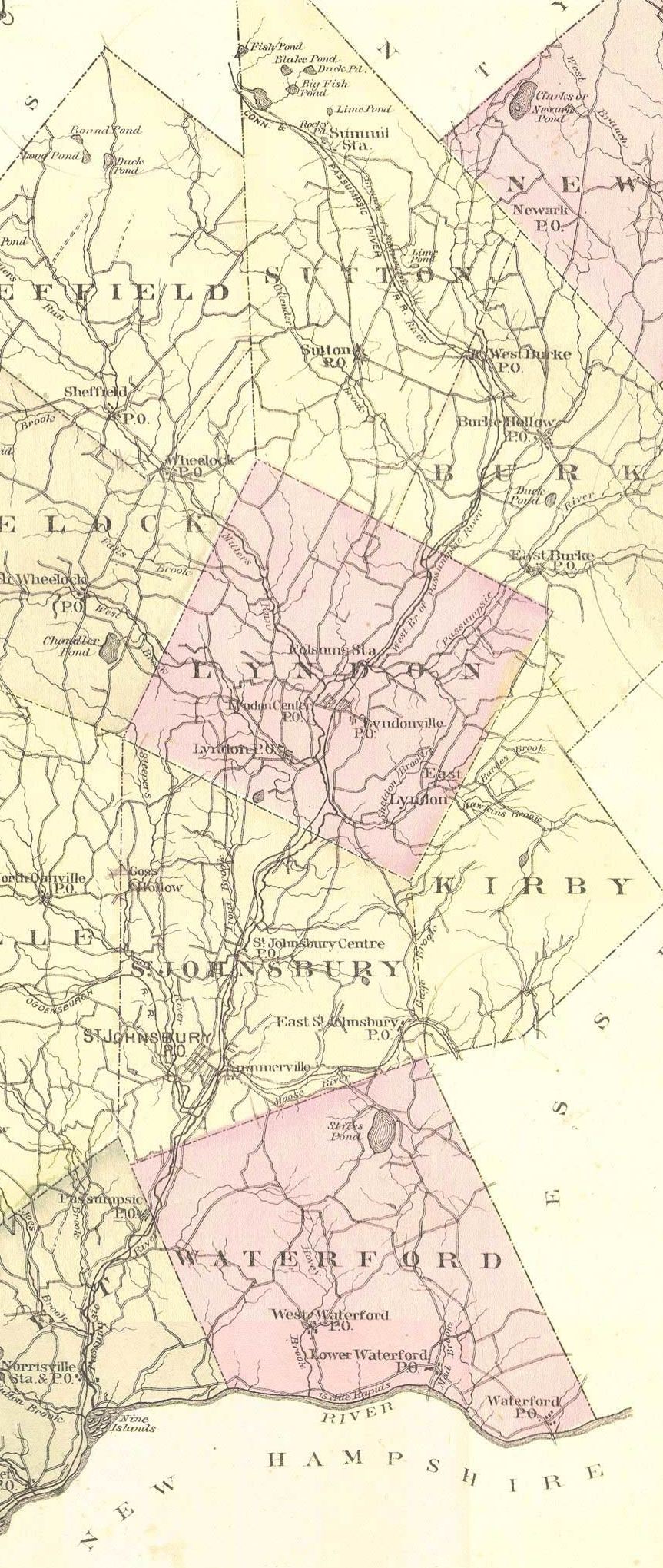
image_size = 125px
caption = The Passumpsic River in 1875
origin = east ofCrystal Lake , northeast ofSutton, VT and north ofSheffield, VT as forks of the Western Branch of the Passumpsic
origin = north ofEast Haven, VT as the Eastern Branch of the Passumpsic
mouth =Connecticut River at Nine Island near East Barnet, VT
basin_countries =United States
length = Main stem 20.2 mi (32 km) [http://oaspub.epa.gov/tmdl/enviro_V4.wcontrol?p_id305b=VT15-01 United States Environmental Protection Agency website, 2006.] , 42.8 mi Western branch [http://oaspub.epa.gov/tmdl/enviro_V4.wcontrol?p_id305b=VT15-07 United States Environmental Protection Agency website, 2006.] , 38.6 mi Eastern branch [http://oaspub.epa.gov/tmdl/enviro_V4.wcontrol?p_id305b=VT15-08 United States Environmental Protection Agency website, 2006.]
elevation = 968 ft (295 m) Western branch, 1010 ft (308 m) Eastern branch
mouth_elevation = 1083 ft (330 m) Main stem
discharge =
watershed = convert|436|mi2|km2|0 [ [http://nh.water.usgs.gov/Publications/annual97/01135500.htm USGS] retrieved July 15, 2008]The Passumpsic River is a tributary of the
Connecticut River , inVermont . Though primarily aCaledonia County river, it is the only river to flow through all three counties of theNortheast Kingdom .Course
The river arises in two branches, one east, the other west. The eastern branch begins just north of East Haven. It flows southwest through Hartwellville, East Haven; then into East Burke.
The western branch starts as several small forks near Crystal Lake, northeast of Sutton. The
Montreal, Maine and Atlantic Railway lines follows the western branch of the Passumpsic until it converges with the eastern branch in Lyndonville.From Lyndon, the river proceeds southerly through St. Johnsbury Center (village) in the town of St. Johnsbury; St. Johnsbury, Passumpsic Village in the town of Barnet; Barnet, and into the Connecticut River near Nine Island.
East Branch
The east branch originates about 1/2 mile southeast of Sukes Pond, Brighton, Essex County. Rte 114 nearly parallels it as it runs south southeast. It soon enters Caledonia County. It is joined by Jack Brook near Howard Brook Road in Newark. It then turns south southwest.
Just before entering East Haven, it is joined by Mill Brook/King Brook entering from the east. It is then joined by the confluence of Bean Brook and Whetstone Brook just inside the town of East Haven, back in Essex County. It goes through Hartwellville, in the town of East Haven, then crosses into Caledonia County for good.
In Burke, a mile downstream, it is joined on the south by Flower Brook which flows mainly from the east. Duck Pond drains into it. It is followed by Route 5A and flows through East Burke. It converges with the west branch before 5A joins US Route 5.
West branch
The west branch first exits out the west side of Newark Pond in Newark. It flows briefly through Barton, back into Newark, then into Burke.
Burke
It proceeds south southwest. Arcadia Brook flows into it from the north near Arcadia Lane. West Brook flows into it from the northwest near VT 5A, which nearly parallels it from then on south. The river flows south from that point. After it crosses 5A going south southwest, another unnamed brook enters it from the east
Sutton River enters it from the southwest, near
U.S. Route 5 at West Burke. Rte 5 now nearly parallels it southbound The river then turns south southeast. An unnamed brook, which "Brook Road" parallels for awhile, enters from the east.Lyndon (west branch only)
In Lyndon it passes through Folsom Village. Quimby and Calendar Brooks enter from the west. The river turns south, near Calendar Brook road intersection with rte 5. The two branches merge near East Burke road just north east of where VT 114 intersects with US 5
Lyndon (after two branches merge)
The joined river continues south. The river turns west, even west northwest at times. An unnamed brook enters from the north. The river turns south. Miller run enters from the west. South Wheelock Branch enters from the west southwest just south of Riverside Court. The river proceeds to the Rt 5 bridge and from there to the Vail Hydro Dam . The river runs southeast, then takes a turn west northwest, as the Sheldon River

- Contact us: Technical Support, Advertising
Passumpsic River
18+
© Academic, 2000-2025
Dictionaries export, created on PHP, Joomla, Drupal, WordPress, MODx.