- National Register of Historic Places listings in North Portland, Oregon
-
 Locator map showing Portland's five quadrants. Click a quadrant to go to its NRHP list.
The following list attempts to comprehensively present the full set of National Register of Historic Places listings in North Portland, Oregon, and offers brief descriptive information about each of them. The National Register of Historic Places (NRHP) recognizes buildings, structures, objects, sites, and districts of national, state, or local historic significance across the United States.[1] Out of over 80,000 NRHP sites nationwide,[2] Oregon is home to approximately 1,900,[3] and over one-fourth of those are found in Portland. While these sites are heavily concentrated in the Downtown, Northwest District, and Southwest Hills neighborhoods, a significant portion are widely spread across all five of Portland's quadrants.
Only NRHP sites within the municipal boundaries of Portland are shown in this list and its companion lists for the other four quadrants. Some sites beyond city limits will appear in other lists showing "Portland" as a general locality, but are excluded here. Although Portland's legal boundaries extend into Clackamas and Washington counties, all of the city's NRHP sites lie within Multnomah County.
-
- This National Park Service list is complete through NPS recent listings posted November 10, 2011.[4]
Contents
Current listings
[5] Site name[6] Image Date listed[6] Location[7] City or Town[8] Summary 1 Henry C. and Wilhemina Bruening House 
November 27, 2004 5919 N Williams Avenue
45°33′57″N 122°40′01″W / 45.5659°N 122.6669°WPortland 2 Paul Bunyan Statue[9] 
January 28, 2009[9] Corner of N Denver Avenue and N Interstate Avenue[9]
45°35′01.76″N 122°41′11.74″W / 45.5838222°N 122.6865944°WPortland[9] This 31-foot (9.4 m) sculpture of folkloric logger Paul Bunyan in Portland's Kenton neighborhood was built in 1959 to commemorate the centennial of Oregon's statehood during the Centennial Exposition and International Trade Fair. Its steel skeleton and detailed, painted-plaster sheathing were crafted by local companies and tradesmen, and it was prominently placed on Interstate Avenue at what was then the main northern gateway to Portland. Reflecting Oregon's tradition of rugged individualism and identification with the timber industry, the statue is an outstanding example of 20th-century, novelty roadside architecture.[10][11] 3 David Cole House 
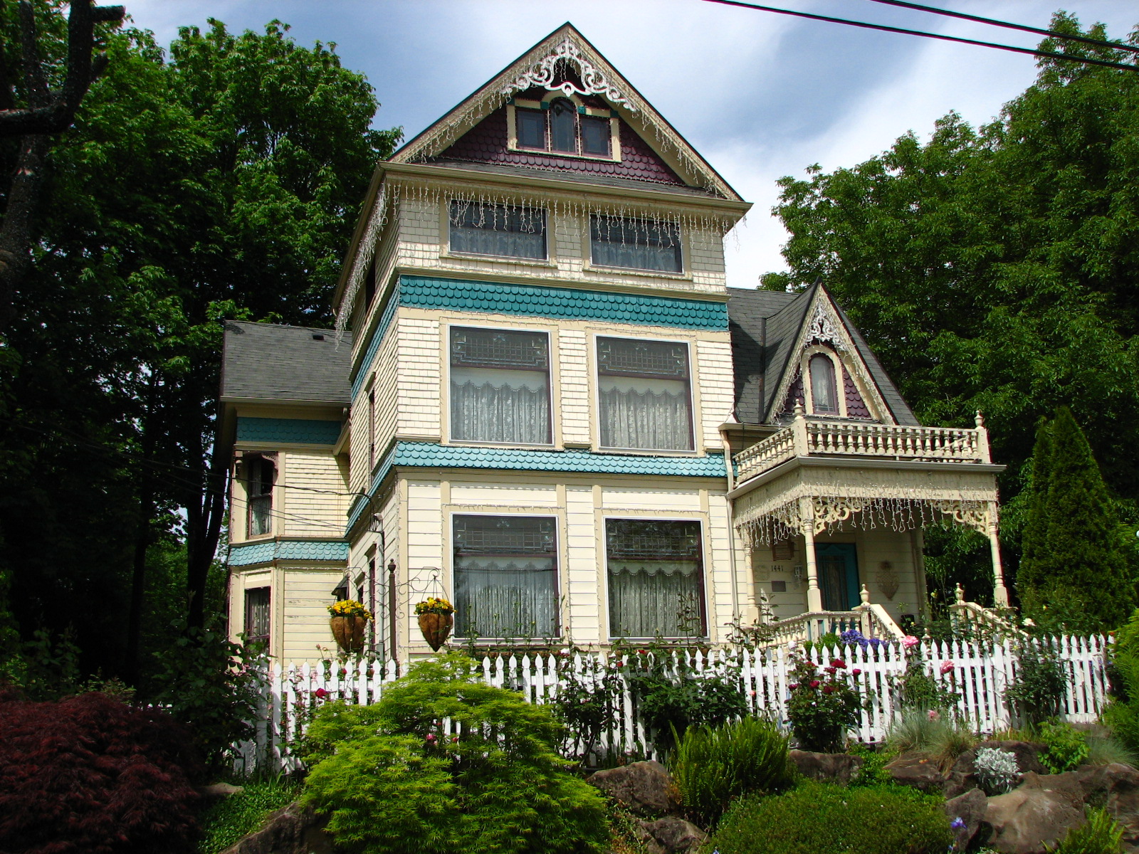
August 6, 1980 1441 N McClellan Street
45°34′59″N 122°40′56″W / 45.58313°N 122.6822°WPortland 4 Charles Crook House 
February 21, 1997 6127 N Williams Avenue
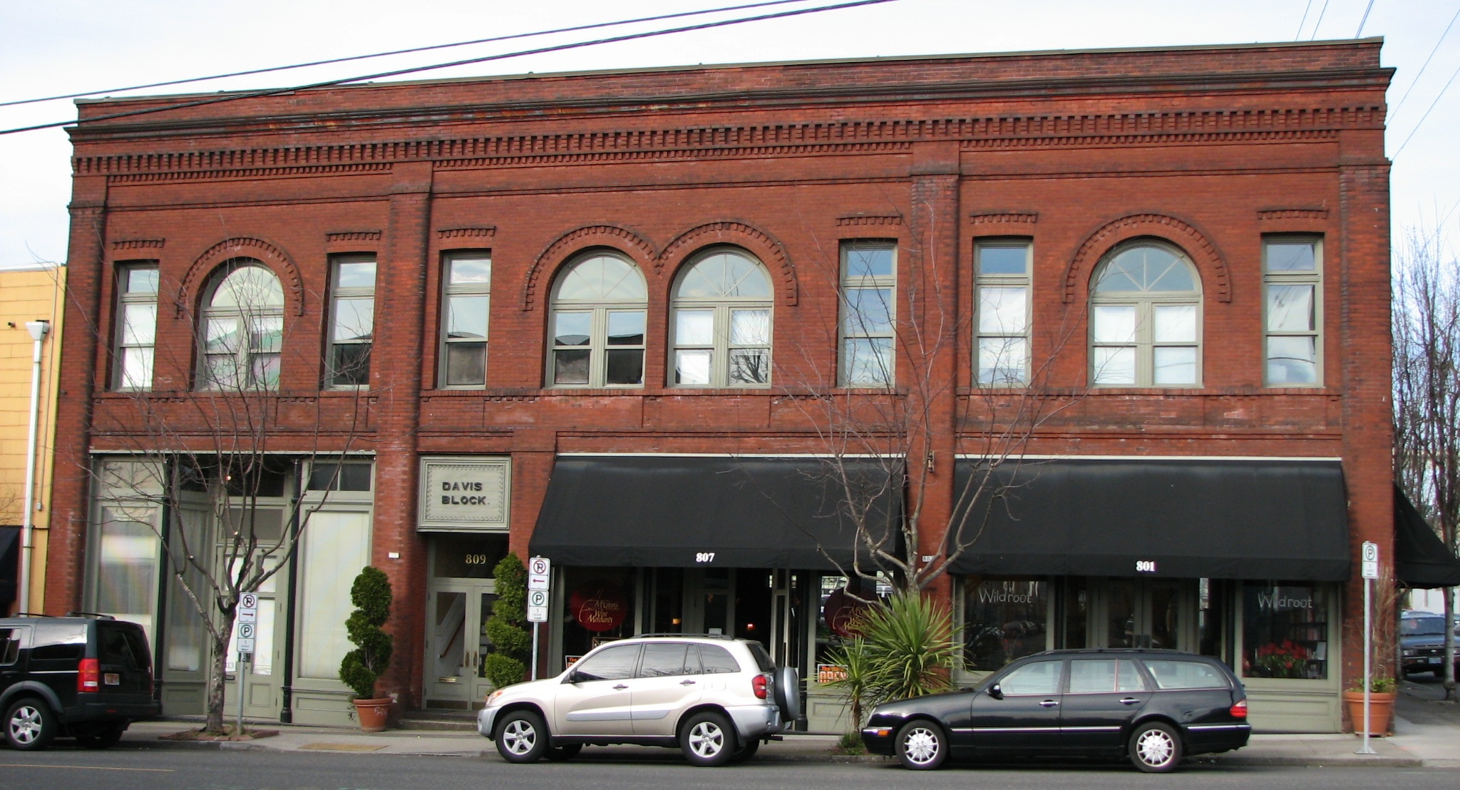
45°34′01″N 122°40′01″W / 45.56701°N 122.6669°WPortland 5 Davis Block 
March 18, 1999 801–813 N Russell Street
45°32′28″N 122°40′30″W / 45.54103°N 122.675°WPortland 6 Elliott House 
September 21, 2005 2022 N Williamette Boulevard
45°33′43″N 122°41′16″W / 45.56195°N 122.6879°WPortland 7 Hryszko Brothers Building 
July 31, 1998 836 N Russell Street
45°32′28″N 122°40′30″W / 45.541°N 122.6751°WPortland 8 Peter Jeppesen House 
September 10, 1987 4107 N Albina Avenue
45°33′13″N 122°40′28″W / 45.5535°N 122.6745°WPortland 9 Kenton Commercial Historic District 
September 3, 2001 Roughly along N Denver Avenue, from N Willis Street to N Watts Street[6]
45°34′57″N 122°41′13″W / 45.58246°N 122.6869°WPortland 10 Kenton Hotel 
October 16, 1990 8303–8319 N Denver Avenue
45°35′00″N 122°41′14″W / 45.58327°N 122.6871°WPortland 11 [1] ) 12 Memorial Coliseum[12] 
September 10, 2009[12] 1401 N Wheeler Avenue[12]
45°31′57″N 122°40′06″W / 45.53247°N 122.66838°W[12][13]Portland[12] 13 John Mock House 
February 15, 1980 4333 N Willamette Boulevard
45°34′31″N 122°42′43″W / 45.57528°N 122.7119°WPortland 14 Mount Hood Masonic Temple[14] 
May 29, 2008[14] 5308 N Commercial Avenue[14]
45°33′43.25″N 122°40′14.92″W / 45.5620139°N 122.6708111°WPortland[14] 15 John Palmer House 
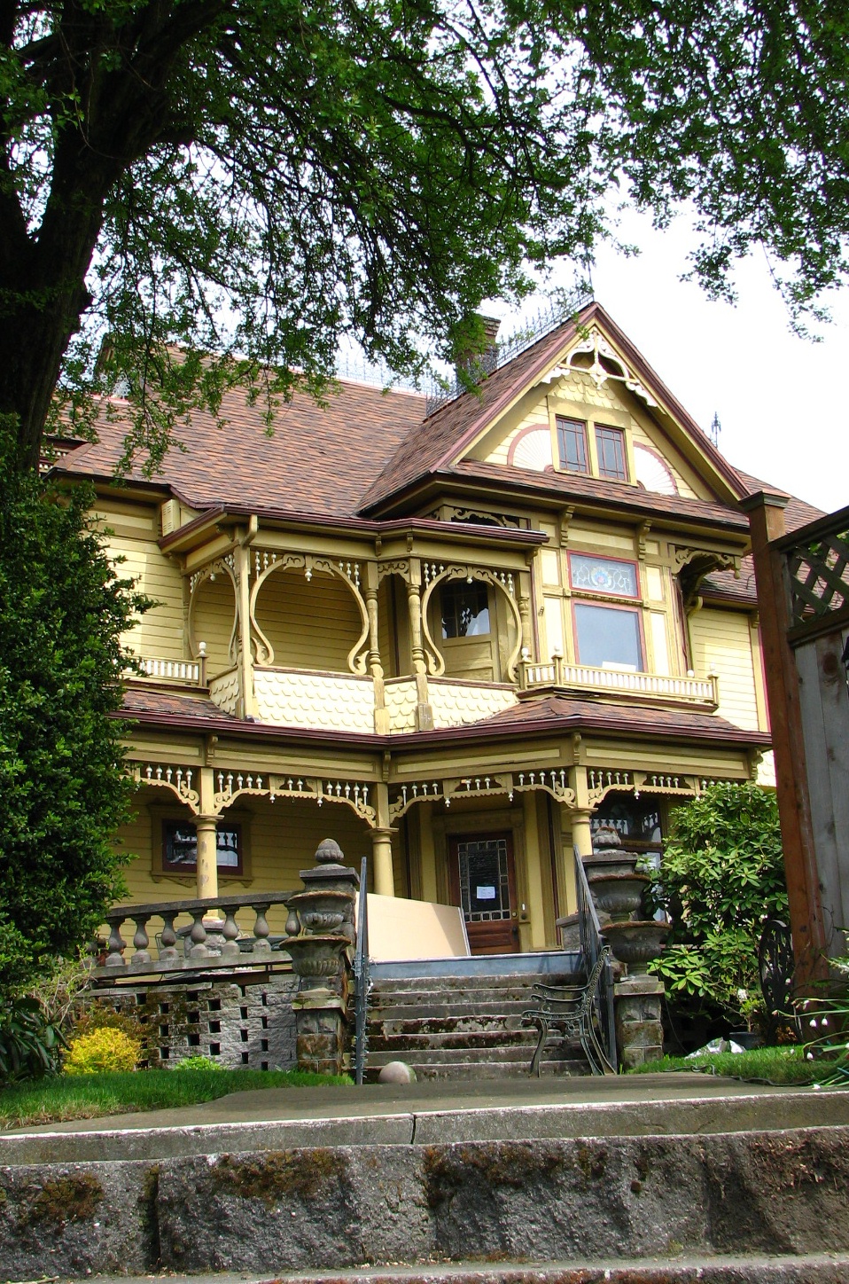
March 8, 1978 4314 N Mississippi Avenue
45°33′17″N 122°40′32″W / 45.55477°N 122.6755°WPortland 16 Thomas M. and Alla M. Paterson House 
March 5, 1998 7807 N Denver Avenue
45°34′47″N 122°41′13″W / 45.57965°N 122.6869°WPortland 17 Portland Van and Storage Building 
February 22, 1996 407 N Broadway[15]
45°32′02.47″N 122°40′14.94″W / 45.5340194°N 122.6708167°WPortland 22 Portland–Vancouver Highway Bridge 
July 16, 1982 Spanning the Columbia River
45°36′23″N 122°40′55″W / 45.60648°N 122.682°WPortland and Vancouver, Washington 18 St. Johns Signal Tower Gas Station 
November 21, 2003 8302 N Lombard Street
45°35′22″N 122°45′08″W / 45.58932°N 122.7521°WPortland 19 Smithson and McKay Brothers Blocks 
August 10, 1979 921–949 N Russell Street
45°32′28″N 122°40′37″W / 45.54121°N 122.6769°WPortland 20 Frederick Torgler Building 
March 18, 1999 816–820 N Russell Street
45°32′28″N 122°40′30″W / 45.541°N 122.675°WPortland 21 US Post Office – St. John's Station 
March 4, 1985 8720 N Ivanhoe Street
45°35′25″N 122°45′23″W / 45.59029°N 122.7563°WPortland Depression-era, small community post office in the Georgian style, with colonial revival elements. It is unusual among small Oregon post offices in that it was designed by a local architect, Francis Marion Stokes.[16] 23 Villa St. Rose 
November 22, 2000 597 N Dekum Street
45°34′19″N 122°40′18″W / 45.57206°N 122.6716°WPortland 24 West Coast Woods Model Home 
September 14, 2002 7211 N Fowler Avenue
45°34′32″N 122°42′25″W / 45.57547°N 122.7069°WPortland 25 West Hall 
September 22, 1977 5000 N Willamette Boulevard
45°34′18.24″N 122°43′28.56″W / 45.5717333°N 122.7246°WPortland 26 Wilson–Chambers Mortuary 
April 5, 2007 430 N Killingsworth Street
45°33′44.83″N 122°40′14.91″W / 45.5624528°N 122.6708083°WPortland 27 John Yeon Speculative House 
August 1, 2007 3922 N Lombard Street
45°34′36.98″N 122°42′27.25″W / 45.5769389°N 122.7075694°WPortland One of a series of speculative houses by native Oregon architect and conservationist John Yeon following the critically acclaimed Watzek House (1937). The series included nine houses built between 1938 and 1940 in Lake Oswego and Portland. The houses used a modular design concept that pioneered the use of external plywood as a building material and separate ventilation louvers, which allowed for series of fixed pane glass to be inset between vertical mullions. Yeon is frequently cited as one of the originators of what became known as the Northwest Regional style of architecture.[citation needed] See also
- National Register of Historic Places listings in: Oregon, Multnomah County, Clackamas County, Washington County
- List of National Historic Landmarks in Oregon
- Historic preservation
- History of Portland, Oregon
- Lists of Oregon-related topics
References
- ^ National Park Service (1997). "How to Apply the National Register Criteria for Evaluation". http://www.nps.gov/history/nr/publications/bulletins/nrb15/nrb15.pdf. Retrieved 2008-12-17
- ^ National Park Service. "National Register Research". National Register of Historic Places. http://www.nps.gov/nr/research/index.htm. Retrieved 2008-12-17.
- ^ Oregon Parks and Recreation Department (2008-08-08). "Oregon National Register List". http://www.oregonheritage.org/OPRD/HCD/NATREG/docs/oregon_nr_list.pdf. Retrieved 2008-10-09
- ^ "National Register of Historic Places: Weekly List Actions". National Park Service, United States Department of the Interior. Retrieved on November 10, 2011.
- ^ Numbers represent an ordering by significant words (e.g. last name). Various colorings (defined here) differentiate standalone NRHP sites from NRHP sites that also hold status as National Historic Landmarks, historic districts, National Historical Parks, or hold other historic designations.
- ^ a b c National Park Service. "National Register Information System". Archived from the original on 2008-05-28. http://web.archive.org/web/20080528011404/http://www.cr.nps.gov/NR/research/nris.htm. Retrieved 2008-10-15.
- ^ Text: Except as otherwise noted, all entries are drawn from: Oregon Parks and Recreation Department (2008-08-08). "Oregon National Register List". http://www.oregonheritage.org/OPRD/HCD/NATREG/docs/oregon_nr_list.pdf.
Coordinates: Except as otherwise noted, all entries are drawn from either: (a) Google Earth KMZ files available at: National Park Service. "National Register Information System". http://www.cr.nps.gov/NR/research/nris.htm. (b) A Google Earth search for the given street address. In limited instances, editors have adjusted coordinates for accuracy. - ^ Except as otherwise noted, all entries are drawn from: Oregon Parks and Recreation Department (2008-08-08). "Oregon National Register List". http://www.oregonheritage.org/OPRD/HCD/NATREG/docs/oregon_nr_list.pdf. Retrieved 2008-10-09
- ^ a b c d National Park Service (2009-02-06). "Weekly List of Actions Taken on Properties: 1/26/09 through 1/30/09". http://www.nps.gov/history/nr/listings/20090206.HTM. Retrieved 2009-02-06.
- ^ Oregon State Historic Preservation Office; Maiya Martin, Bette Davis Nelson (2008-03-19) (PDF). National Register of Historic Places Registration Form: Paul Bunyan Statue. http://www.nps.gov/history/nr/feature/weekly_features/PaulBunyanStatue.pdf.
- ^ For additional details on the nomination process, see also: Bales, Michael (2008-10-09). "Kenton: Historic moment for Paul Bunyan statue?". The Oregonian (Portland). http://www.oregonlive.com/portland/index.ssf/2008/10/kenton_historic_moment_for_pau.html. Retrieved 2009-06-03.
- ^ a b c d e Minor, Kristen (2009-04-21) (PDF). National Register of Historic Places Registration Form: Memorial Coliseum. http://www.oregonheritage.org/OPRD/HCD/NATREG/docs/national_register_recent/Multnomah_MemorialColiseum_nrnom.pdf.
- ^ Coordinates converted from UTM to latitude and longitude using the NAD27 datum, employing the utility at http://www.whimbrel.com/deg_to_utm3.html, accessed on 2009-09-17.
- ^ a b c d National Park Service (2008-06-06). "Weekly List of Actions Taken on Properties: 5/27/08 through 5/30/08". http://www.nps.gov/nr/listings/20080606.HTM. Retrieved 2008-11-29.
- ^ Both the National Register Information System and the Oregon State Historic Preservation Office incorrectly give 407 NE Boradway.
- ^ National Register of Historic Places Nomination Form for Federal Properties - Form No. 10-306, August 31, 1984
External links
City of Portland, Oregon History • Government • Mayors • Neighborhoods • Flag
Transportation • Buildings & Architecture • Hospitals • Education • Famous Portlanders
Tourism • Sports • Artists and Art Institutions
See also: Multnomah County • Portland-Vancouver metro area • Oregon • United States U.S. National Register of Historic Places in Oregon Lists by county Baker • Benton • Clackamas • Clatsop • Columbia • Coos • Crook • Curry • Deschutes • Douglas • Gilliam • Grant • Harney • Hood River • Jackson • Jefferson • Josephine • Klamath • Lake • Lane • Lincoln • Linn • Malheur • Marion • Morrow • Multnomah: Portland North • Multnomah: Portland Northeast • Multnomah: Portland Northwest • Multnomah: Portland Southeast • Multnomah: Portland Southwest • Multnomah: Other • Polk • Sherman • Tillamook • Umatilla • Union • Wallowa • Wasco • Washington • Wheeler • Yamhill
Other lists Keeper of the Register • History of the National Register of Historic Places • Property types • Historic district • Contributing property U.S. National Register of Historic Places Topics Lists by states Alabama • Alaska • Arizona • Arkansas • California • Colorado • Connecticut • Delaware • Florida • Georgia • Hawaii • Idaho • Illinois • Indiana • Iowa • Kansas • Kentucky • Louisiana • Maine • Maryland • Massachusetts • Michigan • Minnesota • Mississippi • Missouri • Montana • Nebraska • Nevada • New Hampshire • New Jersey • New Mexico • New York • North Carolina • North Dakota • Ohio • Oklahoma • Oregon • Pennsylvania • Rhode Island • South Carolina • South Dakota • Tennessee • Texas • Utah • Vermont • Virginia • Washington • West Virginia • Wisconsin • WyomingLists by territories Lists by associated states Other  Category:National Register of Historic Places •
  Portal:National Register of Historic PlacesCategories:
- National Register of Historic Places in Portland, Oregon
- Oregon-related lists
-


Wikimedia Foundation. 2010.