- National Register of Historic Places listings in Lincoln County, Oregon
-
This is a list of properties and districts in Lincoln County, Oregon that are listed on the National Register of Historic Places.
Current listings
Landmark name Image Date listed Location City or Town Summary 1 35-LNC-76-The Ahnkuti Site March 6, 2001 Address Restricted Toledo 2 Archeological site 35LNC48 September 10, 1997 Address Restricted Yachats 3 Archeological site 35LNC63 September 10, 1997 Address Restricted Yachats 4 Archeological site 35LNC68 September 10, 1997 Address Restricted Depoe Bay 5 Archeological Site No. 35-LNC-54 June 21, 2006 Address Restricted Yachats 6 Archeological Site No. 35-LNC-55 June 21, 2006 Address Restricted Yachats 7 Archeological Site No. 35-LNC-56 June 21, 2006 Address Restricted Yachats 8 Archeological Site No. 35-LNC-57 June 21, 2006 Address Restricted Yachats 9 Boiler Bay Site (35LNC45) September 10, 1997 Address Restricted Depoe Bay 10 Cape Perpetua Shelter and Parapet 
March 17, 1989 3 miles south of Yachats
44°17′14″N 124°6′30″W / 44.28722°N 124.10833°WYachats 11 Chitwood Bridge November 29, 1979 Off U.S. Route 20
44°39′8″N 123°48′58″W / 44.65222°N 123.81611°WChitwood 12 Depoe Bay Bridge No. 01388 
August 5, 2005 U.S. Route 101 (Oregon Coastal Highway 9) at milepost O127.61
44°48′36″N 124°3′39″W / 44.81°N 124.06083°WDepoe Bay 13 Devil's Punch Bowl 
September 10, 1997 Oregon coastline at Otter Rock
44°44′48.7176″N 124°3′53.0928″W / 44.746866°N 124.064748°W[1]Otter Rock 14 Dorchester House 
February 29, 1980 2701 U.S. Route 101
44°59′12″N 124°0′19″W / 44.98667°N 124.00528°WLincoln City 15 Fisher School Bridge 
November 29, 1979 Five Rivers Rd.
44°17′33″N 123°50′23″W / 44.2925°N 123.83972°WFisher 16 Government Point Site September 10, 1997 Address Restricted Depoe Bay 17 New Cliff House 
November 6, 1986 267 NW. Cliff St.
44°38′18″N 124°3′40″W / 44.63833°N 124.06111°WNewport 18 North 804 Midden (35LNC72) September 10, 1997 Address Restricted Yachats 19 North Fork of the Yachats Bridge 
November 29, 1979 Northeast of Yachats
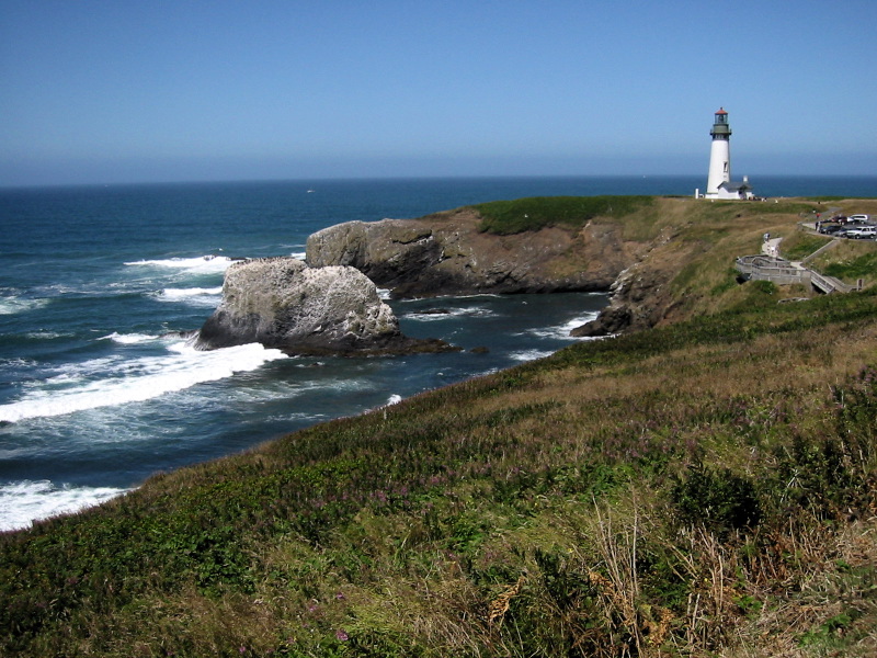
44°18′36″N 123°58′6″W / 44.31°N 123.96833°WYachats 20 Old Yaquina Bay Lighthouse 
May 1, 1974 Yaquina Bay State Park
44°37′27″N 124°3′44″W / 44.62417°N 124.06222°WNewport 21 Pacific Spruce Saw Mill Tenant Houses May 20, 1999 146, 162, 178, and 192 NE. 6th St.
44°37′31″N 123°56′14″W / 44.62528°N 123.93722°WToledo 22 Rocky Creek Bridge No. 01089 
August 5, 2005 Otter Crest Loop Rd., U.S. Route 101 frontage road, at milepost F130.00
44°46′43″N 124°4′13″W / 44.77861°N 124.07028°WOtter Rock 23 Rocky Creek Site (35LNC43) September 10, 1997 Address Restricted Depoe Bay 24 Charles and Theresa Roper House 
December 9, 1981 620 SW. Alder St.
44°38′0″N 124°3′28″W / 44.633333°N 124.05778°WNewport 25 St. John's Episcopal Church October 17, 1990 110 NE. Alder St.
44°37′15″N 123°56′4″W / 44.62083°N 123.93444°WToledo 26 Seal Rock September 10, 1997 Address Restricted Seal Rock 27 Siletz Agency Site January 1, 1976 Siletz-Logsden Rd.
44°43′24″N 123°54′31″W / 44.72333°N 123.90861°WSiletz 28 Smelt Sands Midden (35LNC65) September 10, 1997 Address Restricted Yachats 29 Depoe Bay 30 Trail 804 Midden#3 (35LNC73) September 10, 1997 Address Restricted Yachats 31 US Spruce Production Railroad XII, Spur 5 June 8, 1989 East of Yachats
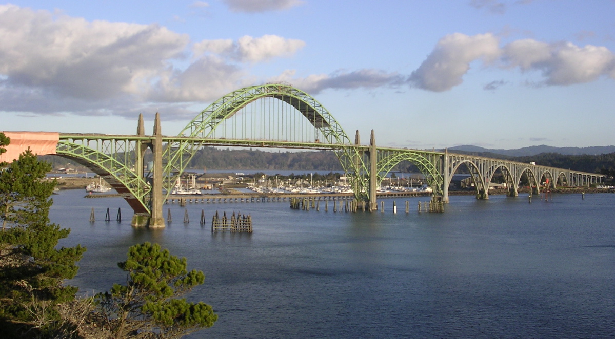
44°18′53″N 124°3′5″W / 44.31472°N 124.05139°WYachats 32 Yachats Trail 804 MIdden (35LNC66) September 10, 1997 Address Restricted Yachats 33 Yaquina Bay Bridge No. 01820 
August 5, 2005 U.S. Route 101 (Oregon Coastal Highway 9) at milepost P141.67
44°37′23″N 124°3′21″W / 44.62306°N 124.05583°WNewport 34 Yaquina Head Lighthouse 
May 13, 1993 Yaquina Head, about 4 miles north of the entrance to the Yaquina River
44°40′37″N 124°4′41″W / 44.67694°N 124.07806°WNewport Related property
Landmark name Image Date Location City or Town Summary 1 Ernest Bloch House February 9, 2009 (determined eligible) 116 NW. Gilbert Way Newport Determined NRHP-eligible (Refnum 09000049). In other situations, this determination is the result of an owner objection to NRHP-listing. See Ernest Bloch. References
U.S. National Register of Historic Places in Oregon Lists by county Baker • Benton • Clackamas • Clatsop • Columbia • Coos • Crook • Curry • Deschutes • Douglas • Gilliam • Grant • Harney • Hood River • Jackson • Jefferson • Josephine • Klamath • Lake • Lane • Lincoln • Linn • Malheur • Marion • Morrow • Multnomah: Portland North • Multnomah: Portland Northeast • Multnomah: Portland Northwest • Multnomah: Portland Southeast • Multnomah: Portland Southwest • Multnomah: Other • Polk • Sherman • Tillamook • Umatilla • Union • Wallowa • Wasco • Washington • Wheeler • Yamhill
Other lists Categories:- National Register of Historic Places listings by county in Oregon
- Lincoln County, Oregon


Wikimedia Foundation. 2010.