Yaquina Bay Bridge

Yaquina Bay Bridge

Infobox_Bridge
bridge_name=Yaquina Bay Bridge
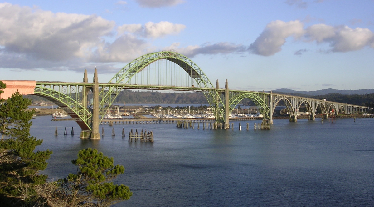


caption=
official_name=
carries=U.S. Route 101
crosses=Yaquina Bay
locale=Newport, Oregon
maint=Oregon DOT
id=
design=
mainspan=600 ft (183 m)
length=3,223 ft (982 m)
width=
height=
clearance=
below=133 ft (40.5 m)
traffic=
open=September 6, 1936
closed=
lat=44.62207
long=-124.05636
The Yaquina Bay Bridge is an arch bridge that spans Yaquina Bay south of Newport, Oregon. It is one of the most recognizable of the U.S. Route 101 bridges designed by Conde McCullough. [cite book | first = Dwight A. | last= Smith| coauthors = Norman, James B.; Dykman, Pieter T. | title = Historic Highway Bridges of Oregon | publisher = Oregon Historical Society Press | date = 1989 | pages = 111 | id = ISBN 0-87595-205-4 ]

The bridge opened on September 6, 1936, at a cost of $1,301,016. A total of 220 people worked to pour 30,000 cubic yards (23,000 m³) of concrete and fabricate 3,100 tons of steel.

The main span is flanked by identical 350 ft (107 m) steel arches. The rest of the structure is constructed of reinforced concrete. [cite book | last = Hadlow | first = Robert W. | title = Elegant Arches, Soaring Spans: C.B. McCullough, Oregon's Master Bridge Builder | publisher = Oregon State University Press | date = 2001 | pages = 139 | id = ISBN 0-87071-534-8 ] One concrete deck girder forms the northern approach, and a series of 5 arches makes up the southern part of the bridge. [cite web | title = Oregon Coastal Highway Bridges | publisher = Oregon Department of Transportation | url = http://egov.oregon.gov/ODOT/HWY/GEOENVIRONMENTAL/historic_bridges_coastal1.shtml | accessdate = 2006-11-10]

The details of the bridge are typical of McCullough's style.

As of August 2006, the bridge is undergoing extensive repainting. Fact|date=February 2007

The bridge is shown in the opening scene of the 2008 film Prom Night.

Gallery

References

External links

* [http://memory.loc.gov/cgi-bin/query/r?ammem/hh:@field(DOCID+@lit(OR0310)) American Memory from the Library of Congress]
* [http://memory.loc.gov/cgi-bin/ampage?collId=hhphoto&fileName=or/or0300/or0310/photos/browse.db&action=browse&recNum=0&title2=Yaquina+Bay+Bridge,+Spans+Yaquina+Bay+at+Oregon+Coast+Highway,+Newport,+Lincoln+County,+OR Misc. photos]


Wikimedia Foundation. 2010.

Игры ⚽ Поможем написать реферат

Look at other dictionaries:

  • Yaquina Bay Bridge — 44.62207 124.05636 Koordinaten: 44° 37′ 19,5″ N, 124° 3′ 22,9″ W f1 …   Deutsch Wikipedia

  • Yaquina Bay — von Norden. Im Vordergrund das Oregon Coast Aquarium und oben rechts die Yaquina Bay Bridge Die Yaquina Bay ist eine flache Bucht an der Westküste der USA im Bundesstaat Oregon im Lincoln County. Die Stadt Newport liegt auf beiden Seiten der… …   Deutsch Wikipedia

  • Yaquina Bay State Park — Der Leuchtturm Yaquina Bay Lighthouse im östlichen Teil des State Parks (2009) …   Deutsch Wikipedia

  • Yaquina Bay — (pronounced ya kwin na or, rarely, ya keen ah ) is a small bay partially within Newport, Oregon, United States, located where the Yaquina River flows into the Pacific Ocean. It is traversed by the Yaquina Bay Bridge. The bay s area is about 8 km² …   Wikipedia

  • Steamboats of Yaquina Bay and Yaquina River — Yaquina Bay, like Coos Bay, is a shallow coastal bay on the Oregon Coast in the Pacific Northwest of North America. The principal town on Yaquina Bay is Newport, Oregon. The Yaquina River flows into the bay. Until modern roads reached Newport in… …   Wikipedia

  • Yaquina — bezeichnet: Yaquina (Volk), ist der Name der Ureinwohner der Pazifikküste in Oregon, USA und ihrer Sprache Yaquina Bay, eine Bucht bei Newport, Oregon, USA Yaquina Bay Bridge, die Brücke über die Yaquina Bay im Verlauf des U.S. Highway 101… …   Deutsch Wikipedia

  • Yaquina — is a place name native to the U.S. state of Oregon. Yaquina can refer to: *Yaquina (people), a Native American tribe (also their language) *Yaquina Bay *Yaquina Bay Bridge *Yaquina Bay Lighthouse *Yaquina Bay State Recreation Site *Yaquina Head… …   Wikipedia

  • Yaquina River — Yaquina Bay mit der Yaquina Bay Bridge und der Mündung des Yaquina Rivers Der Yaquina River ist ein Fluss mit einer Länge von ungefähr 80 Kilometern im US Bundesstaat Oregon. Er entspringt in der Oregon Coast Range westlich von Corvallis im… …   Deutsch Wikipedia

  • Nestucca Bay National Wildlife Refuge — IUCN Category IV (Habitat/Species Management Area) Aerial view of the refuge …   Wikipedia

  • Nehalem Bay State Park — Nehalem Bay State Park …   Wikipedia

Share the article and excerpts

Direct link
Do a right-click on the link above
and select “Copy Link”