- National Register of Historic Places listings in Clarke County, Mississippi
-
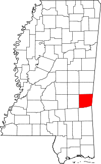 Location of Clarke County in Mississippi
This is a list of the National Register of Historic Places listings in Clarke County, Mississippi.
This is intended to be a complete list of the properties and districts on the National Register of Historic Places in Clarke County, Mississippi, United States. Latitude and longitude coordinates are provided for many National Register properties and districts; these locations may be seen together in a Google map.[1]
There are 50 properties and districts listed on the National Register in the county.
-
- This National Park Service list is complete through NPS recent listings posted November 10, 2011.[2]
Current listings
[3] Landmark name [4] Image Date listed Location City or town Summary 1 Adams-Taylor-McRae House May 22, 1980 East of Pachuta
32°01′18″N 88°47′21″W / 32.021667°N 88.789167°WElwood 2 C.V. Akin House May 20, 1994 Southern side of Clarion St., approximately ¼ mile east of U.S. Route 45
31°58′19″N 88°42′54″W / 31.971944°N 88.715°WDe Soto 3 Asher's Cabin May 22, 1980 Mississippi Highway 513
32°08′53″N 88°48′09″W / 32.148056°N 88.8025°WStonewall 4 Barbour-Estes House May 22, 1980 River Rd.
32°09′57″N 88°49′26″W / 32.165833°N 88.823889°WEnterprise 5 Bradshaw-Booth House May 22, 1980 Stonewall St.
32°09′55″N 88°48′47″W / 32.165278°N 88.813056°WEnterprise 6 Brown-Wilson House May 22, 1980 Mississippi Highway 11
32°09′56″N 88°50′04″W / 32.165556°N 88.834444°WEnterprise 7 Judge John L. Buckley House May 20, 1994 Northern side of Bridge St. at its junction with Hand Ave.
32°10′33″N 88°49′29″W / 32.175833°N 88.824722°WEnterprise 8 Carmichael House May 22, 1980 South of De Soto along the Gulf, Mobile and Ohio railroad tracks
31°58′11″N 88°42′52″W / 31.969722°N 88.714444°WDe Soto 9 Benjamin H. Carter House May 20, 1994 210 Ferrill St.
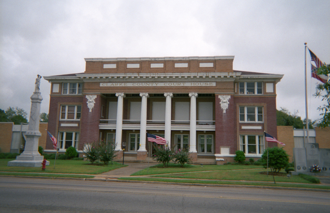
32°02′12″N 88°43′31″W / 32.036667°N 88.725278°WQuitman 10 Clarke County Courthouse and Confederate Monument 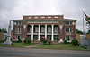
May 20, 1994 Archusa St. at the head of Main St.
32°02′23″N 88°43′39″W / 32.039722°N 88.7275°WQuitman 11 Compton-Short House May 22, 1980 Tuscaboma St.
32°10′28″N 88°48′10″W / 32.174444°N 88.802778°WEnterprise 12 Cook-Sellers House May 22, 1980 E. Station St. De Soto 13 Covington House May 22, 1980 Northeast of De Soto
31°59′15″N 88°42′25″W / 31.9875°N 88.706944°WDe Soto 14 Davis House May 22, 1980 River Rd.
32°10′28″N 88°49′26″W / 32.174444°N 88.823889°WEnterprise 15 Dearman House May 22, 1980 Bridge St. and River Rd.
32°10′27″N 88°49′26″W / 32.174167°N 88.823889°WEnterprise 16 East Enterprise Historic District May 20, 1994 Roughly bounded by S. Stonewall St., Church St., Mississippi Highway 513, and Tuscahoma Rd.
32°10′29″N 88°48′41″W / 32.174722°N 88.811389°WEnterprise 17 Enterprise Bridge November 16, 1988 Spans the Chickasawhay River on Bridge St.
32°10′33″N 88°49′11″W / 32.175833°N 88.819722°WEnterprise 18 Capt. C.C. Ferrill House May 20, 1994 118 E. Franklin St.
32°02′09″N 88°43′31″W / 32.035833°N 88.725278°WQuitman 19 Ford-Williams House May 22, 1980 Mississippi Highway 514
32°11′14″N 88°31′00″W / 32.187222°N 88.516667°WEnergy 20 Forestdale Plantation May 22, 1980 End of County Road 1222, southwest of Quitman
32°0′43″N 88°49′13″W / 32.01194°N 88.82028°W[5]Pachuta 21 Hand House May 22, 1980 North St.
31°51′45″N 88°41′49″W / 31.8625°N 88.696944°WShubuta 22 Highway 11 Bridge over Chunky River November 16, 1988 Spans the Chunky River on U.S. Route 11
32°11′32″N 88°49′30″W / 32.192222°N 88.825°WEnterprise 23 House at 200 East Franklin Street June 2, 1994 200 E. Franklin St.
32°02′10″N 88°43′28″W / 32.036111°N 88.724444°WQuitman 24 House on Old Mill Creek Road May 20, 1994 Western side of Old Mill Creek Rd., between Old Mill Creek Rd. and U.S. Route 11
32°10′38″N 88°49′44″W / 32.177222°N 88.828889°WEnterprise 25 Hunter-Frost House May 22, 1980 River Rd.
32°09′56″N 88°49′25″W / 32.165556°N 88.823611°WEnterprise 26 J.K. Kirkland General Merchandise Store May 20, 1994 124 Main St.
32°02′23″N 88°43′46″W / 32.039722°N 88.729444°WQuitman 27 Lee-Mitts House May 22, 1980 Stonewall St.
32°10′27″N 88°48′48″W / 32.174167°N 88.813333°WEnterprise 28 McCrory-Deas-Buckley House May 22, 1980 Bridge St.
32°10′27″N 88°48′48″W / 32.174167°N 88.813333°WEnterprise 29 Dr. McNair House November 4, 2009 116 E. Church St.
32°02′25″N 88°43′37″W / 32.040233°N 88.726933°WQuitman 30 McNeill-McGee House May 22, 1980 Northeast of Lake Bounds
31°53′23″N 88°53′23″W / 31.889722°N 88.889722°WLake Bounds 31 Methodist Parsonage House May 22, 1980 A St.
32°09′57″N 88°49′26″W / 32.165833°N 88.823889°WEnterprise 32 Noah Moore House May 20, 1994 111 Main St.
32°10′26″N 88°49′32″W / 32.173889°N 88.825556°WEnterprise 33 Overseer's House and Outbuildings of Lang Plantation May 22, 1980 Off County Road 610 in Langsdale
31°53′21″N 88°35′11″W / 31.88917°N 88.58639°W[5]Langsdale 34 Pilgrim's Rest May 22, 1980 Tuscaboma St.
32°10′29″N 88°48′09″W / 32.174722°N 88.8025°WEnterprise 35 Prairie Place May 22, 1980 Off County Road 610 in Langsdale
31°53′21.35″N 88°35′12.28″W / 31.8892639°N 88.5867444°W[5]Langsdale 36 Price-Patton-Pettis House May 22, 1980 North and 2nd Sts.
31°51′47″N 88°41′43″W / 31.863056°N 88.695278°WShubuta 37 Quitman Depot May 20, 1994 Eastern side of the Illinois Central Gulf railroad tracks, near the junction of Main St. and Railroad Ave.
32°02′23″N 88°43′49″W / 32.039722°N 88.730278°WQuitman 38 Riverside Plantation May 22, 1980 Mississippi Highway 11
32°10′59″N 88°50′03″W / 32.183056°N 88.834167°WEnterprise 39 Shubuta Baptist Church June 24, 1994 Eucutta St. at its junction with U.S. Route 45
31°51′37″N 88°42′00″W / 31.860278°N 88.7°WShubuta 40 Shubuta Bridge November 16, 1988 Spans the Chickasawhay River on a county road, east of Shubuta
31°51′25″N 88°41′12″W / 31.856944°N 88.686667°WShubuta 41 Shubuta Methodist Episcopal Church, South May 20, 1994 Eastern side of High St. (U.S. Route 45)
31°51′33″N 88°41′59″W / 31.859167°N 88.699722°WShubuta 42 Smith-McClain-Buckley House May 22, 1980 Stonewall St.
32°09′56″N 88°48′48″W / 32.165556°N 88.813333°WEnterprise 43 Stephenson-Allen House May 22, 1980 Bridge St.
32°10′26″N 88°50′02″W / 32.173889°N 88.833889°WEnterprise 44 Stonewall Mill Village Historic District May 20, 1994 Roughly the area surrounding Erwin Rd. between Alice and Allen Aves.
32°08′08″N 88°47′21″W / 32.135556°N 88.789167°WStonewall 45 Sumrall-Albritton House May 22, 1980 Mississippi Highway 45
31°54′18″N 88°42′31″W / 31.905°N 88.708611°WShubuta 46 Trotter-Byrd House May 22, 1980 419 E. Franklin St.
32°01′55″N 88°43′31″W / 32.031944°N 88.725278°WQuitman 47 Ward House May 22, 1980 3 miles north of Enterprise
32°12′37″N 88°50′05″W / 32.210278°N 88.834722°WEnterprise 48 Jim Williams House May 20, 1994 Western side of N. River Rd., near its junction with Mississippi Highway 513
32°10′34″N 88°49′18″W / 32.176111°N 88.821667°WEnterprise 49 Woolverton-Boyd House May 22, 1980 Off Mississippi Highway 513
32°09′58″N 88°48′45″W / 32.166111°N 88.8125°WEnterprise 50 W.W. Wyatt House May 20, 1994 107 N. River Rd.
32°10′37″N 88°49′18″W / 32.176944°N 88.821667°WEnterprise See also
- List of National Historic Landmarks in Mississippi
- National Register of Historic Places listings in Mississippi
References
- ^ The latitude and longitude information provided in this table was derived originally from the National Register Information System, which has been found to be fairly accurate for about 99% of listings. For about 1% of NRIS original coordinates, experience has shown that one or both coordinates are typos or otherwise extremely far off; some corrections may have been made. A more subtle problem causes many locations to be off by up to 150 yards, depending on location in the country: most NRIS coordinates were derived from tracing out latitude and longitudes off of USGS topographical quadrant maps created under the North American Datum of 1927, which differs from the current, highly accurate WGS84 GPS system used by Google maps. Chicago is about right, but NRIS longitudes in Washington are higher by about 4.5 seconds, and are lower by about 2.0 seconds in Maine. Latitudes differ by about 1.0 second in Florida. Some locations in this table may have been corrected to current GPS standards.
- ^ "National Register of Historic Places: Weekly List Actions". National Park Service, United States Department of the Interior. Retrieved on November 10, 2011.
- ^ Numbers represent an ordering by significant words. Various colorings, defined here, differentiate National Historic Landmark sites and National Register of Historic Places Districts from other NRHP buildings, structures, sites or objects.
- ^ "National Register Information System". National Register of Historic Places. National Park Service. . http://nrhp.focus.nps.gov/natreg/docs/All_Data.html.
- ^ a b c Location derived from this Clarke County Economic Development District webpage; the NRIS lists the site as "Address unknown at this time"
U.S. National Register of Historic Places Topics Lists by states Alabama • Alaska • Arizona • Arkansas • California • Colorado • Connecticut • Delaware • Florida • Georgia • Hawaii • Idaho • Illinois • Indiana • Iowa • Kansas • Kentucky • Louisiana • Maine • Maryland • Massachusetts • Michigan • Minnesota • Mississippi • Missouri • Montana • Nebraska • Nevada • New Hampshire • New Jersey • New Mexico • New York • North Carolina • North Dakota • Ohio • Oklahoma • Oregon • Pennsylvania • Rhode Island • South Carolina • South Dakota • Tennessee • Texas • Utah • Vermont • Virginia • Washington • West Virginia • Wisconsin • WyomingLists by territories Lists by associated states Other Municipalities and communities of Clarke County, Mississippi City 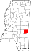
Towns Enterprise | Pachuta | Shubuta | Stonewall
Unincorporated
communityGhost town Categories:- Clarke County, Mississippi
- National Register of Historic Places in Mississippi by county
- Buildings and structures in Clarke County, Mississippi
-

Wikimedia Foundation. 2010.