- Shubuta, Mississippi
Infobox Settlement
official_name = Shubuta, Mississippi
settlement_type =Town
nickname =
motto =
imagesize =
image_caption =
image_
imagesize =
image_caption =
image_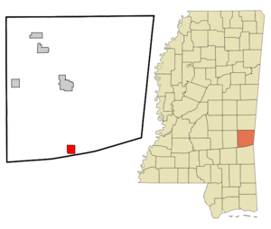
mapsize = 250px
map_caption = Location of Shubuta, Mississippi
mapsize1 =
map_caption1 =subdivision_type = Country
subdivision_name =United States
subdivision_type1 = State
subdivision_name1 =Mississippi
subdivision_type2 = County
subdivision_name2 = Clarke
government_footnotes =
government_type =
leader_title =
leader_name =
leader_title1 =
leader_name1 =
established_title =
established_date =unit_pref = Imperial
area_footnotes =area_magnitude =
area_total_km2 = 6.2
area_land_km2 = 6.2
area_water_km2 = 0.0
area_total_sq_mi = 2.4
area_land_sq_mi = 2.4
area_water_sq_mi = 0.0population_as_of = 2000
population_footnotes =
population_total = 651
population_density_km2 = 104.6
population_density_sq_mi = 271.0timezone = Central (CST)
utc_offset = -6
timezone_DST = CDT
utc_offset_DST = -5
elevation_footnotes =
elevation_m = 62
elevation_ft = 203
latd = 31 |latm = 51 |lats = 39 |latNS = N
longd = 88 |longm = 42 |longs = 2 |longEW = Wpostal_code_type =
ZIP code
postal_code = 39360
area_code = 601
blank_name = FIPS code
blank_info = 28-67520
blank1_name = GNIS feature ID
blank1_info = 0677756
website =
footnotes =Shubuta is a town in Clarke County,
Mississippi ,United States . The population was 651 at the 2000 census.Geography
Shubuta is located at coor dms|31|51|39|N|88|42|2|W|city (31.860939, -88.700690)GR|1.
According to the
United States Census Bureau , the town has a total area of 2.4square mile s (6.2km² ), all of it land.Demographics
As of the
census GR|2 of 2000, there were 651 people, 244 households, and 165 families residing in the town. Thepopulation density was 271.0 people per square mile (104.7/km²). There were 270 housing units at an average density of 112.4/sq mi (43.4/km²). The racial makeup of the town was 25.50% White, 73.89% African American, 0.15% from other races, and 0.46% from two or more races. Hispanic or Latino of any race were 1.38% of the population.There were 244 households out of which 38.1% had children under the age of 18 living with them, 40.2% were married couples living together, 23.8% had a female householder with no husband present, and 32.0% were non-families. 28.7% of all households were made up of individuals and 16.0% had someone living alone who was 65 years of age or older. The average household size was 2.67 and the average family size was 3.35.
In the town the population was spread out with 32.3% under the age of 18, 9.8% from 18 to 24, 26.1% from 25 to 44, 19.7% from 45 to 64, and 12.1% who were 65 years of age or older. The median age was 33 years. For every 100 females there were 83.4 males. For every 100 females age 18 and over, there were 75.7 males.
The median income for a household in the town was $18,438, and the median income for a family was $21,719. Males had a median income of $24,688 versus $17,813 for females. The
per capita income for the town was $9,094. About 38.5% of families and 44.8% of the population were below thepoverty line , including 59.4% of those under age 18 and 35.9% of those age 65 or over.Industry
At one time, Shubuta was the home of Hanson Scale Company, a bathroom scale manufacturer, owned by Sunbeam Corporation.
Education
The Town of Shubuta is served by the
Quitman School District .References
External links
Wikimedia Foundation. 2010.