- National Register of Historic Places listings in Clarke County, Georgia
-
This is a list of properties and districts in Clarke County, Georgia that are listed on the National Register of Historic Places (NRHP).
-
- This National Park Service list is complete through NPS recent listings posted November 10, 2011.[1]
Current listings
Landmark name Image Date listed Location City or Town Summary 1 Athens Factory July 31, 1980 Baldwin and Williams Sts.
33°57′10″N 83°22′10″W / 33.95278°N 83.36944°WAthens 2 Athens Manufacturing Company December 31, 2002 585 While Circle
33°54′20″N 83°21′28″W / 33.90556°N 83.35778°WAthens 3 Athens Warehouse Historic District October 20, 1988 Roughly bounded by Hancock and Thomas Sts., and the RR tracks
33°57′32″N 83°22′17″W / 33.95889°N 83.37139°WAthens 4 Bishop House March 16, 1972 Jackson St., University of Georgia campus
33°57′21″N 83°22′23″W / 33.95583°N 83.37306°WAthens 5 Bloomfield Street Historic District April 18, 1985 Roughly bounded by Bloomfield and Peabody Sts., U of G campus, Rutherford St and Milledge Ave.
33°56′44″N 83°23′6″W / 33.94556°N 83.385°WAthens 6 Boulevard Historic District April 18, 1985 Roughly bounded by the Seaboard Coastline RR tracks, Pulaski St., Prince Ave., and Hiawassee St.
33°57′54″N 83°23′23″W / 33.965°N 83.38972°WAthens 7 Brightwell Shotgun Row June 14, 2001 366-376 Barber St.
33°57′59″N 83°23′8″W / 33.96639°N 83.38556°WAthens 8 Buena Vista Heights Historic District August 27, 1999 Roughly bounded by Park Ave., Prince Ave., Pound St., and Nantahala Extension
33°57′58″N 83°24′6″W / 33.96611°N 83.40167°WAthens 9 Camak House 
July 7, 1975 279 Meigs St.
33°57′32″N 83°22′59″W / 33.95889°N 83.38306°WAthens 10 Carnegie Library Building November 11, 1975 1401 Prince Ave.
33°57′50″N 83°24′16″W / 33.96389°N 83.40444°WAthens 11 Albon Chase House August 19, 1974 185 N. Hull St.
33°57′27″N 83°22′45″W / 33.9575°N 83.37917°WAthens 12 Chestnut Grove School June 28, 1984 610 Epps Bridge Rd.
33°55′59″N 83°26′18″W / 33.93306°N 83.43833°WAthens 13 Church-Waddel-Brumby House February 20, 1975 280 E. Dougherty St.
33°57′43″N 83°22′33″W / 33.96194°N 83.37583°WAthens 14 Clarke County Jail May 29, 1980 Courthouse Sq.
33°57′34″N 83°23′6″W / 33.95944°N 83.385°WAthens 15 T. R. R. Cobb House 
June 30, 1975 194 Prince Ave.
33°57′40″N 83°22′54″W / 33.96111°N 83.38167°WAthens 16 Cobb-Treanor House May 8, 1979 1234 S. Lumpkin St.
33°56′42″N 83°22′46″W / 33.945°N 83.37944°WAthens 17 Cobbham Historic District August 24, 1978 Roughly bounded by Prince Ave., Hill, Reese, and Pope Sts.
33°57′32″N 83°23′31″W / 33.95889°N 83.39194°WAthens 18 Coca-Cola Bottling Plant-Athens February 1, 2006 297 Prince Ave.
33°57′35″N 83°23′0″W / 33.95972°N 83.383333°WAthens 19 Ross Crane House June 18, 1979 247 Pulaski St.
33°57′30″N 83°22′51″W / 33.95833°N 83.38083°WAthens 20 Dearing Street Historic District September 5, 1975 Roughly bounded by Broad and Baxter Sts., Milledge Ave., and includes both sides of Finley St. and Henderson Ave.
33°57′11″N 83°23′7″W / 33.95306°N 83.38528°WAthens 21 Albin P. Dearing House 
May 8, 1979 338 S. Milledge Ave.
33°57′6″N 83°23′16″W / 33.95167°N 83.38778°WAthens 22 Downtown Athens Historic District August 10, 1978 Roughly bounded by Hancock Ave., Foundry, Mitchell
33°57′30″N 83°22′25″W / 33.95833°N 83.37361°WAthens 23 First African Methodist Episcopal Church March 10, 1980 521 N. Hull St.
33°57′39″N 83°22′46″W / 33.96083°N 83.37944°WAthens 24 Franklin House 
December 11, 1974 464-480 E. Broad St.
33°57′28″N 83°22′35″W / 33.95778°N 83.37639°WAthens 25 Garden Club of Georgia Museum-Headquarters House, Founder's Memorial Garden April 26, 1972 Lumpkin St., University of Georgia campus
33°57′15″N 83°22′33″W / 33.95417°N 83.37583°WAthens 26 Gospel Pilgrim Cemetery April 19, 2006 530 Fourth St.
33°58′9″N 83°21′41″W / 33.96917°N 83.36139°WAthens 27 Henry W. Grady House 
May 11, 1976 634 Prince Ave.
33°58′14″N 83°23′19″W / 33.97056°N 83.38861°WAthens 28 Dr. James S. Hamilton House April 24, 1979 150 S. Milledge Ave.
33°57′16″N 83°23′19″W / 33.95444°N 83.38861°WAthens 29 Jackson Street Cemetery October 2, 2009 S. Jackson St., University of Georgia campus
33°57′21″N 83°22′25″W / 33.95583°N 83.37361°WAthens 30 Lucy Cobb Institute Campus March 16, 1972 200 N. Milledge Ave., University of Georgia campus
33°57′22″N 83°23′23″W / 33.95611°N 83.38972°WAthens 31 Gov. Wilson Lumpkin House March 16, 1972 Cedar St., University of Georgia campus
33°56′51″N 83°22′26″W / 33.9475°N 83.37389°WAthens 32 Joseph Henry Lumpkin House 
June 27, 1975 248 Prince Ave.
33°57′38″N 83°22′57″W / 33.96056°N 83.3825°WAthens 33 Milledge Avenue Historic District April 18, 1985 Milledge Ave. from Broad St. to Five Points
33°56′52″N 83°23′16″W / 33.94778°N 83.38778°WAthens Boundary increase (listed September 24, 2009): 295 W. Rutherford St. 34 Milledge Circle Historic District April 18, 1985 Milledge Park, Lumpkin St., Milledge Circle and Milledge Ave.
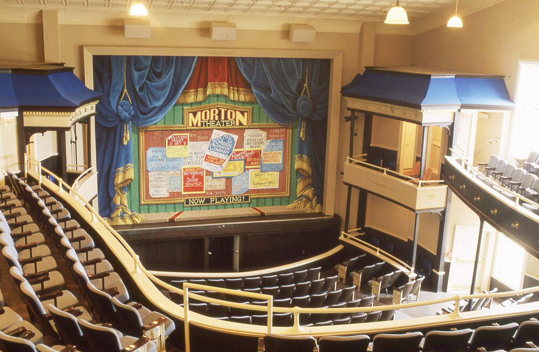
33°56′15″N 83°23′22″W / 33.9375°N 83.38944°WAthens 35 Morton Building 
October 22, 1979 199 W. Washington St.
33°57′31″N 83°22′43″W / 33.95861°N 83.37861°WAthens 36 Newton House July 11, 2002 892 Prince Ave.
33°57′43″N 83°23′34″W / 33.96194°N 83.39278°WAthens 37 Oglethorpe Avenue Historic District November 5, 1987 Oglethorpe Ave.
33°57′58″N 83°24′15″W / 33.96611°N 83.40417°WAthens 38 Old North Campus, University of Georgia March 16, 1972 Bounded by Broad, Lumpkin, and Jackson Sts.
33°58′1″N 83°22′30″W / 33.96694°N 83.375°WAthens 39 Hubert Bond Owens House May 14, 2008 215 W. Rutherford St.
33°56′33.72″N 83°23′9.6″W / 33.9427°N 83.386°WAthens 40 Calvin W. Parr House September 9, 1982 277 Bloomfield St.
33°56′53″N 83°23′9″W / 33.94806°N 83.38583°WAthens 41 Parrott Insurance Building October 7, 1977 283 E. Broad St.
33°57′28″N 83°22′30″W / 33.95778°N 83.375°WAthens 42 President's House March 16, 1972 570 Prince Ave.
33°57′41″N 83°23′11″W / 33.96139°N 83.38639°WAthens 43 Reese Street Historic District November 10, 1987 Roughly bounded by Meigs, Finley, Broad, & Harris Sts.
33°57′26″N 83°23′6″W / 33.95722°N 83.385°WAthens 44 Rocksprings Shotgun Row Historic District August 23, 1996 433-447 Rocksprings St.
33°56′50″N 83°23′29″W / 33.94722°N 83.39139°WAthens 45 James A. Sledge House 
February 12, 1974 749 Cobb St.
33°57′37″N 83°23′49″W / 33.96028°N 83.39694°WAthens 46 R. P. Sorrells House January 22, 1992 220 Prince Ave.
33°57′38″N 83°22′56″W / 33.96056°N 83.38222°WAthens 47 Thomas-Carithers House May 8, 1979 530 S. Milledge Ave.
33°56′56″N 83°23′16″W / 33.94889°N 83.38778°WAthens 48 Upson House November 15, 1973 1022 Prince Ave.
33°57′14″N 83°23′40″W / 33.95389°N 83.39444°WAthens 49 Ware-Lyndon House March 15, 1976 293 Hoyt St.
33°57′50″N 83°22′35″W / 33.96389°N 83.37639°WAthens 50 West Cloverhurst Avenue Historic District September 27, 2007 W. Cloverhurst Ave. vet. Springdale St. and S. Milledge Ave.
33°56′39.34″N 83°23′29.87″W / 33.9442611°N 83.3916306°WAthens 51 West Hancock Avenue Historic District March 30, 1988 Roughly bounded by Hill, Franklin, Broad Sts. and the Plaza
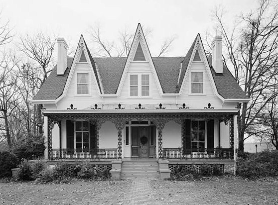
33°57′20″N 83°23′38″W / 33.95556°N 83.39389°WAthens 52 White Hall June 18, 1979 Whitehall and Simonton Bridge Rds.
33°53′48″N 83°21′50″W / 33.89667°N 83.36389°WWhitehall 53 Wilkins House May 19, 1970 387 S. Milledge Ave.
33°57′4″N 83°23′12″W / 33.95111°N 83.38667°WAthens 54 Winterville Historic District October 11, 2001 Roughly center on Main St. and on the abandoned Georgia RR line within the city limits of Winterville
33°58′3″N 83°16′40″W / 33.9675°N 83.27778°WWinterville 55 Woodlawn Historic District October 23, 1987 Woodlawn Ave.
33°56′31″N 83°22′53″W / 33.94194°N 83.38139°WAthens 56 Young Women's Christian Association Complex May 12, 1987 345-347 W. Hancock St.
33°57′31″N 83°22′51″W / 33.95861°N 83.38083°WAthens References
- ^ "National Register of Historic Places: Weekly List Actions". National Park Service, United States Department of the Interior. Retrieved on November 10, 2011.
Categories:- National Register of Historic Places in Georgia (U.S. state)
- Buildings and structures in Clarke County, Georgia
-
Wikimedia Foundation. 2010.