National Register of Historic Places listings in Jackson County, Georgia
- National Register of Historic Places listings in Jackson County, Georgia
-
This is a list of properties and districts in Jackson County, Georgia that are listed on the National Register of Historic Places (NRHP).
-
- This National Park Service list is complete through NPS recent listings posted November 10, 2011.[1]
Current listings
|
Landmark name |
Image |
Date listed |
Location |
City or Town |
Summary |
| 1 |
Braselton Historic District |
|
02001-04-27 April 27, 2001 |
Jct. of GA 124 and GA 53
34°6′33″N 83°45′48″W / 34.10917°N 83.76333°W / 34.10917; -83.76333 (Braselton Historic District) |
Braselton |
|
| 2 |
Commerce Commercial Historic District |
|
01989-01-19 January 19, 1989 |
Roughly bounded by Line, State, Cherry, Sycamore and Broad Sts.
34°12′13″N 83°27′24″W / 34.20361°N 83.45667°W / 34.20361; -83.45667 (Commerce Commercial Historic District) |
Commerce |
|
| 3 |
Governor L. G. Hardman House |
|
01988-06-16 June 16, 1988 |
208 Elm St.
34°12′4″N 83°27′22″W / 34.20111°N 83.45611°W / 34.20111; -83.45611 (Hardman, Governor L. G., House) |
Commerce |
|
| 4 |
Hillcrest-Allen Clinic and Hospital |
|
01985-05-02 May 2, 1985 |
GA 53 & Peachtree Rd.
34°5′18″N 83°45′29″W / 34.08833°N 83.75806°W / 34.08833; -83.75806 (Hillcrest-Allen Clinic and Hospital) |
Hoschton |
|
| 5 |
Holder Plantation |
|
01990-09-05 September 5, 1990 |
Jct. of Possum Creek Rd. and US 129
34°9′3″N 83°37′13″W / 34.15083°N 83.62028°W / 34.15083; -83.62028 (Holder Plantation) |
Jefferson |
|
| 6 |
Hoschton Depot |
|
02000-03-31 March 31, 2000 |
4276 GA 53
34°5′49″N 83°45′41″W / 34.09694°N 83.76139°W / 34.09694; -83.76139 (Hoschton Depot) |
Hoschton |
|
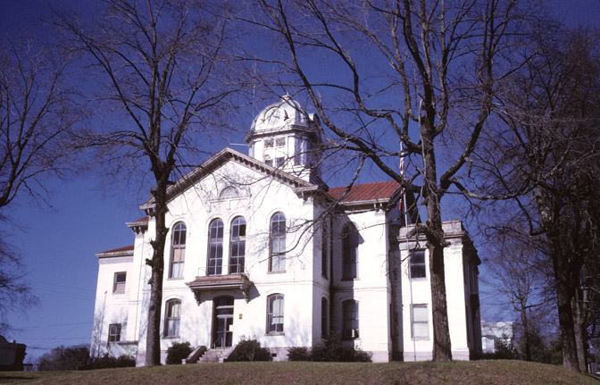
| 7 |
Jackson County Courthouse |
 |
01980-09-18 September 18, 1980 |
GA 1
34°7′6″N 83°34′28″W / 34.11833°N 83.57444°W / 34.11833; -83.57444 (Jackson County Courthouse) |
Jefferson |
|
| 8 |
Jefferson Historic District |
|
02003-03-26 March 26, 2003 |
Roughly centered on the downtown central business district fo Jefferson extending to city limits to NW and SW
34°7′1″N 83°34′42″W / 34.11694°N 83.57833°W / 34.11694; -83.57833 (Jefferson Historic District) |
Jefferson |
|
| 9 |
Maysville Historic District |
|
01985-09-12 September 12, 1985 |
Along E. Main, W. Main and Homer Sts.
34°15′17″N 83°33′48″W / 34.25472°N 83.56333°W / 34.25472; -83.56333 (Maysville Historic District) |
Maysville |
|
| 10 |
Oak Avenue Historic District |
|
02002-05-30 May 30, 2002 |
S of jct. of Oak Ave. and the Southern RR
34°6′36″N 83°34′47″W / 34.11°N 83.57972°W / 34.11; -83.57972 (Oak Avenue Historic District) |
Jefferson |
|
| 11 |
Paradise Cemetery |
|
02002-05-30 May 30, 2002 |
E of Southern RR bet. Lawrenceville St. and Mahaffey Circle
34°7′8″N 83°34′56″W / 34.11889°N 83.58222°W / 34.11889; -83.58222 (Paradise Cemetery) |
Jefferson |
|
| 12 |
Seaborn M. Shankle House |
|
01979-11-29 November 29, 1979 |
125 Cherry St
34°12′9″N 83°27′18″W / 34.2025°N 83.455°W / 34.2025; -83.455 (Shankle, Seaborn M., House) |
Commerce |
|
| 13 |
Shields-Etheridge Farm |
|
01992-06-25 June 25, 1992 |
Jct. of GA 319 and Co. Rd. 125, approximately 5 mi. SW of Jefferson
34°4′5″N 83°35′27″W / 34.06806°N 83.59083°W / 34.06806; -83.59083 (Shields--Etheridge Farm) |
Jackson |
|
| 14 |
Talmo Historic District |
|
01997-09-15 September 15, 1997 |
Roughly along Main St., Kinney Ave., and A.J. Irvin Rd.
34°11′6″N 83°43′13″W / 34.185°N 83.72028°W / 34.185; -83.72028 (Talmo Historic District) |
Talmo |
|
| 15 |
Williamson-Maley-Turner Farm |
|
01995-07-07 July 7, 1995 |
GA 15 NE of Jefferson
34°8′52″N 83°31′10″W / 34.14778°N 83.51944°W / 34.14778; -83.51944 (Williamson--Maley--Turner Farm) |
Jefferson |
|
References
Categories:
- National Register of Historic Places in Georgia (U.S. state)
- Buildings and structures in Jackson County, Georgia
Wikimedia Foundation.
2010.
Look at other dictionaries:
National Register of Historic Places listings in Fulton County, Georgia — This is a list of properties and districts in Fulton County, Georgia that are listed on the National Register of Historic Places (NRHP). It covers most of the NRHP properties in Atlanta, Georgia; other Atlanta listings are covered in National… … Wikipedia
National Register of Historic Places listings in Jackson County, Iowa — Location of Jackson County in Iowa This is a list of the National Register of Historic Places listings in Jackson County, Iowa. This is intended to be a complete list of the properties and districts on the National Register of Historic Places in… … Wikipedia
National Register of Historic Places listings in Jackson County, Arkansas — Location of Jackson County in Arkansas This is a list of the National Register of Historic Places listings in Jackson County, Arkansas. This is intended to be a complete list of the properties and districts on the National Register of Historic… … Wikipedia
National Register of Historic Places listings in Jackson County, Indiana — Location of Jackson County in Indiana This is a list of the National Register of Historic Places listings in Jackson County, Indiana. This is intended to be a complete list of the properties and districts on the National Register of Historic… … Wikipedia
National Register of Historic Places listings in Jackson County, Mississippi — Location of Jackson County in Mississippi This is a list of the National Register of Historic Places listings in Jackson County, Mississippi. This is intended to be a complete list of the properties and districts on the National Register of… … Wikipedia
National Register of Historic Places listings in Jackson County, Oklahoma — Location of Jackson County in Oklahoma This is a list of the National Register of Historic Places listings in Jackson County, Oklahoma. This is intended to be a complete list of the properties on the National Register of Historic Places in… … Wikipedia
National Register of Historic Places listings in Jackson County, Kentucky — Location of Jackson County in Kentucky This is a list of the National Register of Historic Places listings in Jackson County, Kentucky. It is intended to be a complete list of the properties on the National Register of Historic Places in Jackson… … Wikipedia
National Register of Historic Places listings in Jackson County, South Dakota — Location of Jackson County in South Dakota This is a list of the National Register of Historic Places listings in Jackson County, South Dakota. This is intended to be a complete list of the properties and districts on the National Register of… … Wikipedia
National Register of Historic Places listings in Jackson County, North Carolina — Map of all coordinates from Google Map of all coordinates from Bing … Wikipedia
National Register of Historic Places listings in Jackson County, Michigan — The following is a list of Registered Historic Places in Jackson County, Michigan. This National Park Service list is complete through NPS recent listings posted November 10, 2011.[1] [2] Landmark name … Wikipedia