National Register of Historic Places listings in Baldwin County, Georgia
- National Register of Historic Places listings in Baldwin County, Georgia
-
This is a list of properties and districts in Baldwin County, Georgia that are listed on the National Register of Historic Places (NRHP).
-
- This National Park Service list is complete through NPS recent listings posted November 10, 2011.[1]
Current listings
| [2] |
Landmark name |
Image |
Date listed |
Location |
City or town |
Summary |
| 1 |
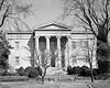
Andalusia |
|
01980-02-08February 8, 1980 |
NW of Milledgeville on U.S. 441
33°02′13″N 83°16′20″W / 33.036944°N 83.272222°W / 33.036944; -83.272222 (Andalusia) |
Milledgeville |
|
| 2 |
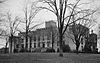
Atkinson Hall, Georgia College |
|
01972-01-20January 20, 1972 |
Georgia College campus
33°04′49″N 83°13′51″W / 33.080278°N 83.230833°W / 33.080278; -83.230833 (Atkinson Hall, Georgia College) |
Milledgeville |
|
| 3 |
Barrowville |
|
01978-12-14December 14, 1978 |
E of Milledgeville on GA 22/24
33°05′18″N 83°12′17″W / 33.088333°N 83.204722°W / 33.088333; -83.204722 (Barrowville) |
Milledgeville |
|
| 4 |
Maj. Francis Boykin House |
|
01978-11-14November 14, 1978 |
10 mi. (16 km) SE of Milledgeville off GA 24
33°00′41″N 83°05′22″W / 33.011389°N 83.089444°W / 33.011389; -83.089444 (Maj. Francis Boykin House) |
Milledgeville |
|
| 5 |
Central Building, State Lunatic Asylum |
|
01978-07-20July 20, 1978 |
Broad St.
33°03′01″N 83°13′19″W / 33.050278°N 83.221944°W / 33.050278; -83.221944 (Central Building, State Lunatic Asylum) |
Milledgeville |
|
| 6 |
Central State Hospital Cemeteries |
|
02005-07-12July 12, 2005 |
3 mi. SE of Milledgeville, centered on Cedar Lm, at Central State Hospital, bet. US 441 and GA 112
33°02′20″N 83°13′12″W / 33.038889°N 83.22°W / 33.038889; -83.22 (Central State Hospital Cemeteries) |
Hardwick |
|
| 7 |
Devereux-Coleman House |
|
01993-04-08April 8, 1993 |
167 Kenan Dr.
33°08′47″N 83°16′53″W / 33.146389°N 83.281389°W / 33.146389; -83.281389 (Devereux-Coleman House) |
Milledgeville |
|
| 8 |
Fort-Hammond-Willis House |
|
02003-03-25March 25, 2003 |
1760 Irwinton rd.
33°03′25″N 83°13′46″W / 33.056944°N 83.229444°W / 33.056944; -83.229444 (Fort-Hammond-Willis House) |
Milledgeville |
|
| 9 |
Fowler Apartments |
|
01997-08-21August 21, 1997 |
430 W. McIntosh St.
33°04′52″N 83°14′00″W / 33.081111°N 83.233333°W / 33.081111; -83.233333 (Fowler Apartments) |
Milledgeville |
|
| 10 |
Milledgeville Historic District |
|
01972-06-28June 28, 1972 |
Bounded by Irwin, Thomas, and Warren Sts. and Fishing Creek
33°04′42″N 83°13′43″W / 33.078333°N 83.228611°W / 33.078333; -83.228611 (Milledgeville Historic District) |
Milledgeville |
|
| 11 |
Old Governor's Mansion |
|
01970-05-13May 13, 1970 |
120 S. Clark St.
33°04′42″N 83°13′53″W / 33.078333°N 83.231389°W / 33.078333; -83.231389 (Old Governor's Mansion) |
Milledgeville |
|
| 12 |
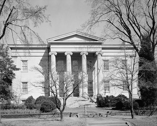
Old State Capitol |
|
01970-05-13May 13, 1970 |
Greene St.
33°04′40″N 83°13′30″W / 33.077778°N 83.225°W / 33.077778; -83.225 (Old State Capitol) |
Milledgeville |
|
| 13 |
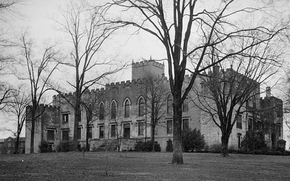
Old State Prison Building |
|
01979-05-08May 8, 1979 |
3 mi. (4.8 km) W of Milledgeville on GA 22
33°05′40″N 83°16′31″W / 33.094444°N 83.275278°W / 33.094444; -83.275278 (Old State Prison Building) |
Milledgeville |
|
| 14 |
Samuel Rockwell House |
|
01978-04-19April 19, 1978 |
165 Allen Memorial Dr.
33°03′24″N 83°14′00″W / 33.056667°N 83.233333°W / 33.056667; -83.233333 (Samuel Rockwell House) |
Milledgeville |
|
| 15 |
Roe-Harper House |
|
01986-03-06March 6, 1986 |
Off US 441
33°09′57″N 83°16′39″W / 33.165833°N 83.2775°W / 33.165833; -83.2775 (Roe-Harper House) |
Milledgeville |
|
| 16 |
John Rutherford House |
|
01978-03-21March 21, 1978 |
550 Allen Memorial Dr.
33°03′18″N 83°14′28″W / 33.055°N 83.241111°W / 33.055; -83.241111 (John Rutherford House) |
Milledgeville |
|
| 17 |
Storehouse, State Lunatic Asylum |
|
01978-06-15June 15, 1978 |
Broad St. and Lawrence Rd.
33°03′03″N 83°13′26″W / 33.050833°N 83.223889°W / 33.050833; -83.223889 (Storehouse, State Lunatic Asylum) |
Milledgeville |
|
| 18 |
Thalian Hall |
|
01978-03-21March 21, 1978 |
Allen Memorial and Ivey Drs.
33°03′19″N 83°14′43″W / 33.055278°N 83.245278°W / 33.055278; -83.245278 (Thalian Hall) |
Milledgeville |
|
| 19 |
Westbrook-Hubert Farm |
|
01997-06-13June 13, 1997 |
143 Little Rd.
33°09′24″N 83°20′17″W / 33.156667°N 83.338056°W / 33.156667; -83.338056 (Westbrook-Hubert Farm) |
Meriwether |
|
| 20 |
Westover |
|
01987-02-12February 12, 1987 |
151 Meriwether Rd. NW
33°07′50″N 83°17′44″W / 33.130556°N 83.295556°W / 33.130556; -83.295556 (Westover) |
Milledgeville |
|
| 21 |
Woodville |
|
01979-06-22June 22, 1979 |
3 mi. (4.8 km) S of Milledgeville on GA 243
33°01′04″N 83°14′32″W / 33.017778°N 83.242222°W / 33.017778; -83.242222 (Woodville) |
Milledgeville |
|
References
Categories: - National Register of Historic Places in Georgia (U.S. state)
- Buildings and structures in Baldwin County, Georgia
Wikimedia Foundation.
2010.
Look at other dictionaries:
National Register of Historic Places listings in Fulton County, Georgia — This is a list of properties and districts in Fulton County, Georgia that are listed on the National Register of Historic Places (NRHP). It covers most of the NRHP properties in Atlanta, Georgia; other Atlanta listings are covered in National… … Wikipedia
National Register of Historic Places listings in Clarke County, Georgia — This is a list of properties and districts in Clarke County, Georgia that are listed on the National Register of Historic Places (NRHP). Map of all coordinates from Google Map of all coordinates from Bing … Wikipedia
National Register of Historic Places listings in Chatham County, Georgia — This is a list of properties and districts in Chatham County, Georgia that are listed on the National Register of Historic Places (NRHP). Map of all coordinates from Google Map of all coordinates from Bing … Wikipedia
National Register of Historic Places listings in Muscogee County, Georgia — This is a list of properties and districts in Muscogee County, Georgia that are listed on the National Register of Historic Places (NRHP). Map of all coordinates from Google Map of all coordinates from Bing … Wikipedia
National Register of Historic Places listings in Meriwether County, Georgia — This is a list of properties and districts in Meriwether County, Georgia that are listed on the National Register of Historic Places (NRHP). Map of all coordinates from Google Map of all coordinates from Bing … Wikipedia
National Register of Historic Places listings in Banks County, Georgia — This is a list of properties and districts in Banks County, Georgia that are listed on the National Register of Historic Places (NRHP). Map of all coordinates from Google Map of all coordinates from Bing … Wikipedia
National Register of Historic Places listings in Bartow County, Georgia — This is a list of properties and districts in Bartow County, Georgia that are listed on the National Register of Historic Places (NRHP). Map of all coordinates from Google Map of all coordinates from Bing … Wikipedia
National Register of Historic Places listings in Bibb County, Georgia — This is a list of properties and districts in Bibb County, Georgia that are listed on the National Register of Historic Places (NRHP). Map of all coordinates from Google Map of all coordinates from Bing … Wikipedia
National Register of Historic Places listings in Bulloch County, Georgia — This is a list of properties and districts in Bulloch County, Georgia that are listed on the National Register of Historic Places (NRHP). Map of all coordinates from Google Map of all coordinates from Bing … Wikipedia
National Register of Historic Places listings in Catoosa County, Georgia — This is a list of properties and districts in Catoosa County, Georgia that are listed on the National Register of Historic Places (NRHP). Map of all coordinates from Google Map of all coordinates from Bing … Wikipedia