National Register of Historic Places listings in McIntosh County, Georgia
- National Register of Historic Places listings in McIntosh County, Georgia
-
This is a list of properties and districts in McIntosh County, Georgia that are listed on the National Register of Historic Places (NRHP).
-
- This National Park Service list is complete through NPS recent listings posted November 10, 2011.[1]
Current listings
|
Landmark name |
Image |
Date listed |
Location |
City or Town |
Summary |
| 1 |
Behavior Cemetery |
|
01996-08-22 August 22, 1996 |
S end of Sapelo Island, 1.25 mi W of Hog Hammock
31°25′43″N 81°16′52″W / 31.42861°N 81.28111°W / 31.42861; -81.28111 (Behavior Cemetery) |
Hog Hammock |
|
| 2 |
D'Antignac House |
 |
01977-12-16 December 16, 1977 |
Address Restricted |
Crescent |
Demolished[2] |
| 3 |
First African Baptist Church at Raccoon Bluff |
|
01996-09-06 September 6, 1996 |
E side of Sapelo Island, approximately 2 mi. N of Hog Hammock
31°28′0″N 81°13′57″W / 31.466667°N 81.2325°W / 31.466667; -81.2325 (First African Baptist Church at Raccoon Bluff) |
Hog Hammock |
|
| 4 |
Fort Barrington |
|
01972-09-27 September 27, 1972 |
NW of Cox
31°28′49″N 81°37′0″W / 31.48028°N 81.616667°W / 31.48028; -81.616667 (Fort Barrington) |
Cox |
|
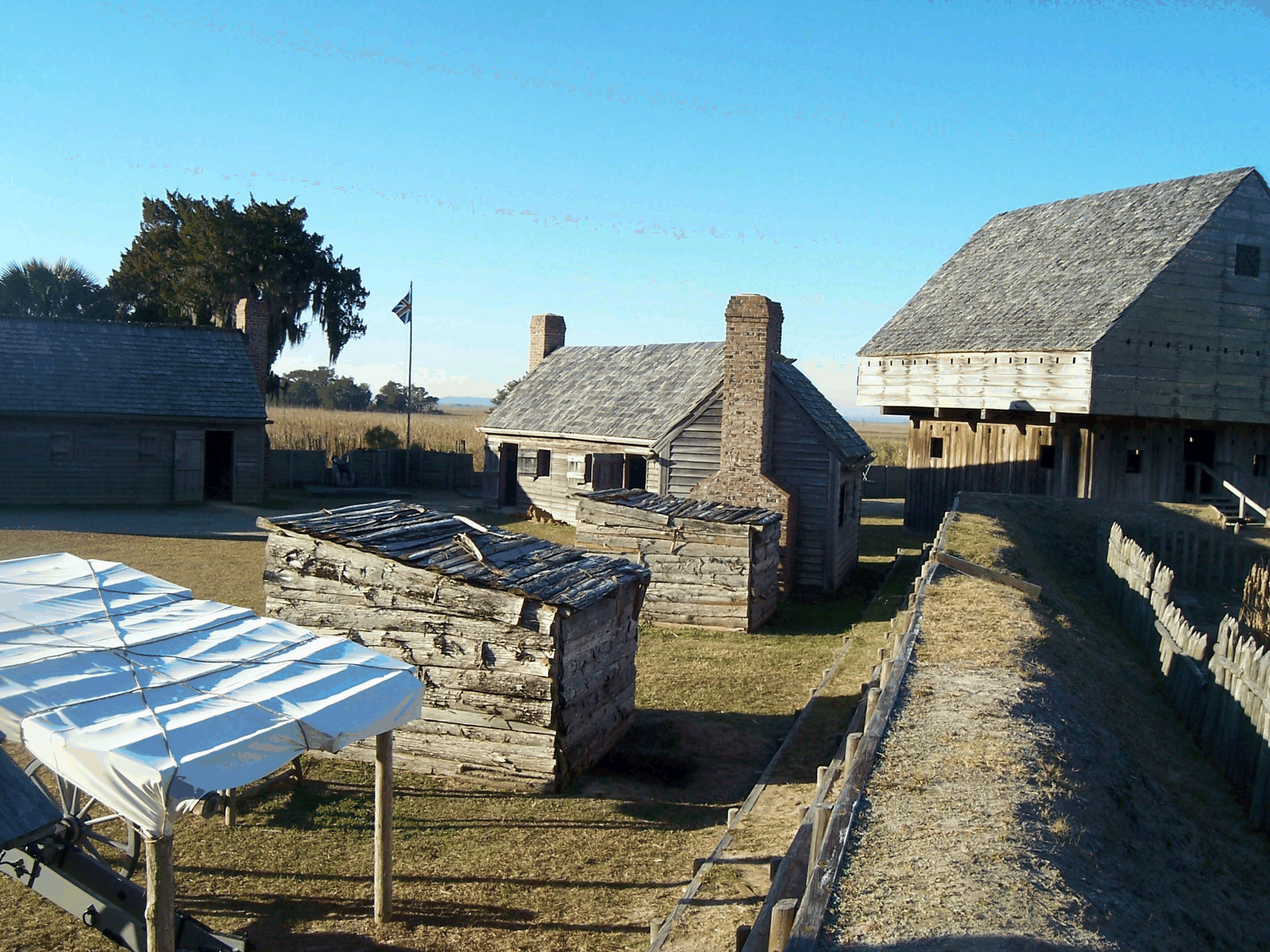
| 5 |
Fort King George |
 |
01971-12-09 December 9, 1971 |
E of U.S. 17
31°21′54″N 81°24′56″W / 31.365°N 81.41556°W / 31.365; -81.41556 (Fort King George) |
Darien |
|
| 6 |
Hog Hammock Historic District |
|
01996-09-06 September 6, 1996 |
E side of Sapelo Island
31°25′40″N 81°15′38″W / 31.42778°N 81.26056°W / 31.42778; -81.26056 (Hog Hammock Historic District) |
Hog Hammock |
|
| 7 |
The Ridge |
 |
01985-04-18 April 18, 1985 |
Old Shell Rd. GA 99
31°24′12″N 81°24′13″W / 31.40333°N 81.40361°W / 31.40333; -81.40361 (Ridge, The) |
Ridgeville |
|
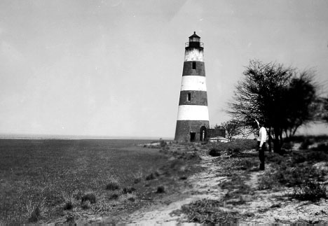
| 8 |
Sapelo Island Lighthouse |
 |
01997-08-26 August 26, 1997 |
S end of Sapelo Island, S of University of Georgia Marine Institute
31°25′10″N 81°16′52″W / 31.41944°N 81.28111°W / 31.41944; -81.28111 (Sapelo Island Lighthouse) |
Sapelo Island |
|
| 9 |
Vernon Square-Columbus Square Historic District |
 |
01985-03-14 March 14, 1985 |
Roughly bounded by Market, Trumbull, Rittenhouse and Ft. King George Dr.
31°22′10″N 81°25′55″W / 31.36944°N 81.43194°W / 31.36944; -81.43194 (Vernon Square-Columbus Square Historic District) |
Darien |
|
| 10 |
West Darien Historic District |
 |
02001-09-17 September 17, 2001 |
Bounded by 8th St., US 17, Darien River, and Cathead Creek
31°22′22″N 81°26′13″W / 31.37278°N 81.43694°W / 31.37278; -81.43694 (West Darien Historic District) |
Darien |
|
References
Categories:
- National Register of Historic Places in Georgia (U.S. state)
- Buildings and structures in McIntosh County, Georgia
Wikimedia Foundation.
2010.
Look at other dictionaries:
National Register of Historic Places listings in Fulton County, Georgia — This is a list of properties and districts in Fulton County, Georgia that are listed on the National Register of Historic Places (NRHP). It covers most of the NRHP properties in Atlanta, Georgia; other Atlanta listings are covered in National… … Wikipedia
National Register of Historic Places listings in McIntosh County, Oklahoma — Location of McIntosh County in Oklahoma This is a list of the National Register of Historic Places listings in McIntosh County, Oklahoma. This is intended to be a complete list of the properties and districts on the National Register of Historic… … Wikipedia
National Register of Historic Places listings in Camden County, Georgia — This is a list of properties and districts in Camden County, Georgia that are listed on the National Register of Historic Places (NRHP). Map of all coordinates from Google Map of all coordinates from Bing … Wikipedia
National Register of Historic Places listings in Baldwin County, Georgia — This is a list of properties and districts in Baldwin County, Georgia that are listed on the National Register of Historic Places (NRHP). Map of all coordinates from Google Map of all coordinates from Bing … Wikipedia
National Register of Historic Places listings in Muscogee County, Georgia — This is a list of properties and districts in Muscogee County, Georgia that are listed on the National Register of Historic Places (NRHP). Map of all coordinates from Google Map of all coordinates from Bing … Wikipedia
National Register of Historic Places listings in Elbert County, Georgia — This is a list of properties and districts in Elbert County, Georgia that are listed on the National Register of Historic Places (NRHP). Map of all coordinates from Google Map of all coordinates from Bing … Wikipedia
National Register of Historic Places listings in Liberty County, Georgia — This is a list of properties and districts in Liberty County, Georgia that are listed on the National Register of Historic Places (NRHP). Map of all coordinates from Google Map of all coordinates from Bing … Wikipedia
National Register of Historic Places listings in Banks County, Georgia — This is a list of properties and districts in Banks County, Georgia that are listed on the National Register of Historic Places (NRHP). Map of all coordinates from Google Map of all coordinates from Bing … Wikipedia
National Register of Historic Places listings in Bartow County, Georgia — This is a list of properties and districts in Bartow County, Georgia that are listed on the National Register of Historic Places (NRHP). Map of all coordinates from Google Map of all coordinates from Bing … Wikipedia
National Register of Historic Places listings in Bibb County, Georgia — This is a list of properties and districts in Bibb County, Georgia that are listed on the National Register of Historic Places (NRHP). Map of all coordinates from Google Map of all coordinates from Bing … Wikipedia