- Memorial Park Site
-
Memorial Park Site
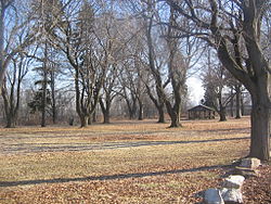 View of the park

Location: South Water Street, Lock Haven, Pennsylvania[2][3] Coordinates: 41°8′18″N 77°25′3″W / 41.13833°N 77.4175°WCoordinates: 41°8′18″N 77°25′3″W / 41.13833°N 77.4175°W Area: 19 acres (7.7 ha) Governing body: Veterans of Foreign Wars (VFW), Lock Haven NRHP Reference#: 82003783[1] Added to NRHP: April 14, 1982 The Memorial Park Site, also known as Memorial Park Site 36Cn164, is an archaeological site located near the confluence of Bald Eagle Creek and the West Branch Susquehanna River in Lock Haven in the U.S. state of Pennsylvania.[2] Research projects conducted at the site since 1979 have found prehistoric cultural deposits that collectively span 8,000 years.[4]
Stratified in age-related sequence, the deposits represent every major prehistoric period from the Middle Archaic to the Late Woodland.[4] The site's dominant component holds the remains of an early Late Woodland (500–1000 CE) village inhabited by people of the Clemson Island culture.[2][4] The convergent streams and their two valleys made the site readily accessible to pre-Columbian people living in both drainage basins.[2]
Memorial Park contains the only area on the West Branch side of the point of land between the river and the creek that has not been disturbed by subsequent development. Alluvial deposits 20 to 28 inches (51 to 71 cm) deep cover the site and have protected it from recent activity on the surface. The Veterans of Foreign Wars acquired the property in the 1920s and used it for a park.[2]
Piper Aircraft bought the fields adjacent to the park in the 1960s to use for airport runways and airplane storage. In the 1970s, Conran A. Hay, a consultant, discovered the prehistoric site during an archeological survey conducted for the United States Army Corps of Engineers. Subsequent research sponsored by the Office of State Archeology and the Office of Historic Preservation of the Pennsylvania Historical and Museum Commission in 1980 helped determine the site boundaries.[2]
See also
- List of archaeological periods (North America)
- List of Native American archaeological sites on the National Register of Historic Places in Pennsylvania
- National Register of Historic Places listings in Clinton County, Pennsylvania
References
- ^ "National Register Information System". National Register of Historic Places. National Park Service. 2008-04-24. http://nrhp.focus.nps.gov/natreg/docs/All_Data.html.
- ^ a b c d e f "National Register of Historic Places Inventory—Nomination Form: Memorial Park Site, 36Cn164" (PDF). National Park Service. September 1, 1980. https://www.dot7.state.pa.us/ce_imagery/phmc_scans/H001002_01H.pdf. Retrieved November 20, 2009.
- ^ Approximate location derived by entering information into Google Earth from the National Register of Historic Places nomination form.
- ^ a b c Schuldenrein, Joseph; Vento, Frank; R. Christopher Goodwin and Associates, Inc. (July 19, 1994). "Geoarcheological Investigations at the Memorial Park Site (36CN164), Pennsylvania" (PDF). United States Army Corps of Engineers, Baltimore District. p. 1-1. http://www.dtic.mil/cgi-bin/GetTRDoc?AD=ADA302109&Location=U2&doc=GetTRDoc.pdf. Retrieved November 22, 2009.
 Late Woodland cultures
Mound builder (people) · List of archaeological periods (North America) Sites Baytown Site · Beattie Park Mound Group · Book Site · Bowen Site (12 MA 61) · Brinsfield I Site · Brokaw Site · Clampitt Site (12-LR-329) · Fisher Site · Hoye Site · Little Maquoketa River Mounds State Preserve · Memorial Park Site · Mott Mounds · Nottingham Site · Ormond Mound · Sommerheim Park · Troyville Earthworks · University of Tennessee Agriculture Farm Mound ·Cultures Alachua culture · Baytown culture · Clemson Island culture · Coles Creek culture · Manahoac · Monongahela culture · Oliver Phase · Plum Bayou culture · Springwells Phase · Troyville culture · Weeden Island culture ·Related topics · Steuben point · Belle Glade culture · Extreme weather events of 535–536 · Fort Ancient culture · Mississippian culture · Oneota · St. Johns culture · U.S. National Register of Historic Places Topics Lists by states Alabama • Alaska • Arizona • Arkansas • California • Colorado • Connecticut • Delaware • Florida • Georgia • Hawaii • Idaho • Illinois • Indiana • Iowa • Kansas • Kentucky • Louisiana • Maine • Maryland • Massachusetts • Michigan • Minnesota • Mississippi • Missouri • Montana • Nebraska • Nevada • New Hampshire • New Jersey • New Mexico • New York • North Carolina • North Dakota • Ohio • Oklahoma • Oregon • Pennsylvania • Rhode Island • South Carolina • South Dakota • Tennessee • Texas • Utah • Vermont • Virginia • Washington • West Virginia • Wisconsin • WyomingLists by territories Lists by associated states Other  Category:National Register of Historic Places •
  Portal:National Register of Historic PlacesCategories:
- Archaic period in the Americas
- Archaeological sites on the National Register of Historic Places in Pennsylvania
- Clinton County, Pennsylvania


Wikimedia Foundation. 2010.