- Mann Mound
-
Mann Mound
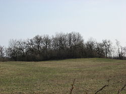 Overview of the mound from the north
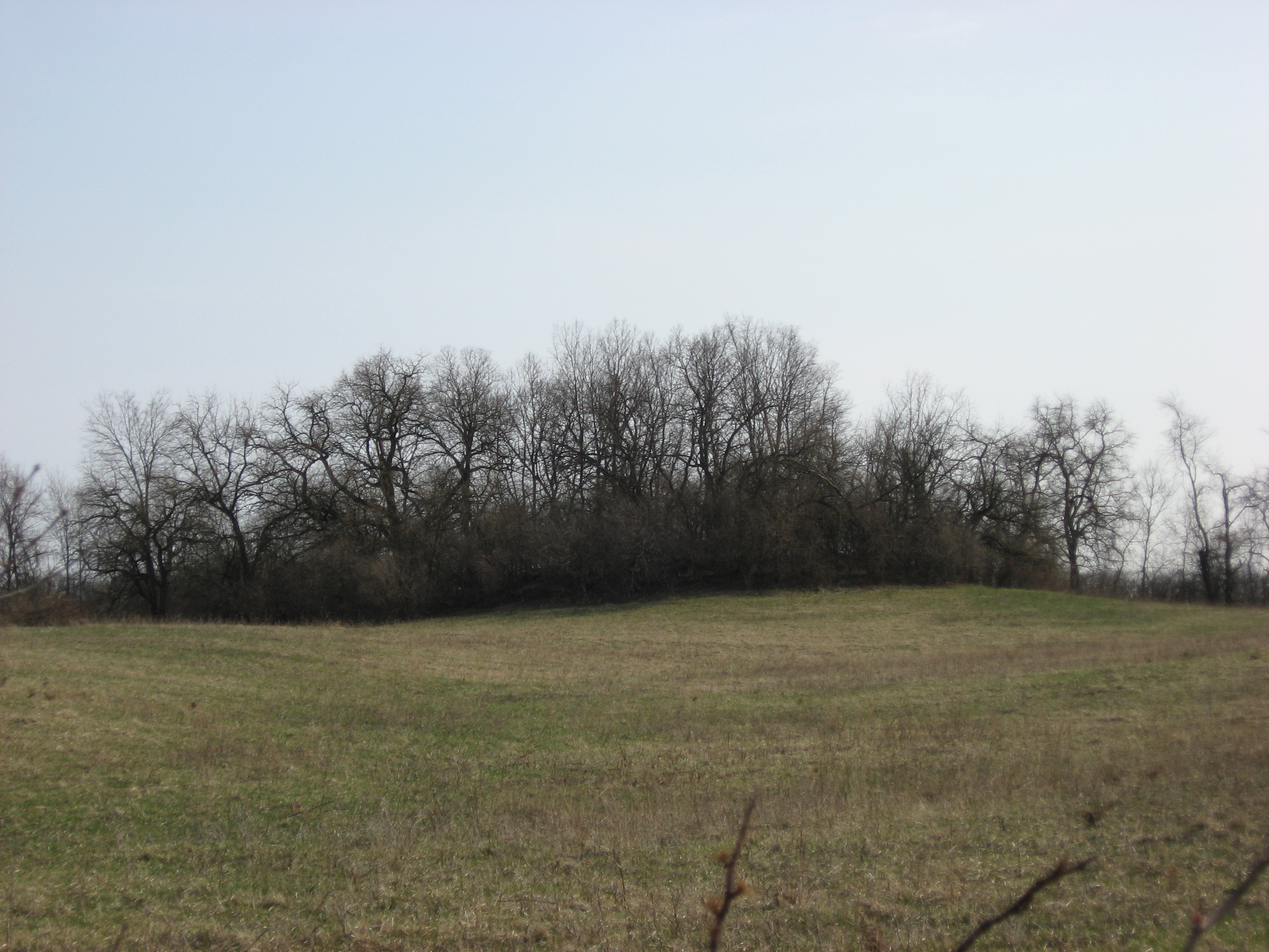

Location: Section 12 of Wayne Township,[2] northeast of Jacksonburg[3] Nearest city: Jacksonburg, Ohio Coordinates: 39°33′5.4″N 84°29′42″W / 39.5515°N 84.495°WCoordinates: 39°33′5.4″N 84°29′42″W / 39.5515°N 84.495°W Area: 1 acre (0.40 ha) Governing body: Private NRHP Reference#: 71000632[1] Added to NRHP: October 7, 1971 The Mann Mound is a Native American mound in the southwestern part of the U.S. state of Ohio. Located near the unincorporated community of Jacksonburg in Butler County,[1] it is tree-covered and sits on the edge of a field[4] in Section 12 of Wayne Township. Its height is approximately 20 feet (6.1 m), and its circumference is approximately 540 feet (160 m).[2]
In November of 1868, the mound was quarried for gravel by local residents; this excavation continued until the miners had reached the center of the mound, where they found multiple limestone burial vaults. These vaults were built as squares, 3 feet (0.91 m) on each side; each contained a skeleton that had presumably been placed in a seated position. The vaults were stacked from the mound's floor to a position just underneath its summit; each was separated from others by a small amount of gravel. Eight skeletons were removed from these vaults and sent to the Smithsonian Institution.[2] Findings from the mound have led to the conclusion that it is a work of the Adena culture.[1]
Despite the damage done by the amateur excavation, the Mann Mound is still a significant archaeological site and the second largest extant mound in Butler County. It was recorded by an archaeological survey published by J.P. MacLean in 1879,[4] and in 1971, it was recognized for its archaeological significance when it was listed on the National Register of Historic Places.[1]
References
- ^ a b c d "National Register Information System". National Register of Historic Places. National Park Service. 2009-03-13. http://nrhp.focus.nps.gov/natreg/docs/All_Data.html.
- ^ a b c MacLean, J. P. The Mound Builders: Being an Account of a Remarkable People that Once Inhabited the Valleys of the Ohio and Mississippi, Together with an Investigation Into the Archæology of Butler County, O. Cincinnati: Clarke, 1879, 221.
- ^ Mills, William C. Archeological Atlas of Ohio. Columbus: Ohio State Archeological and Historical Society, 1914, page 9 and plate 9.
- ^ a b Owen, Lorrie K., ed. Dictionary of Ohio Historic Places. Vol. 1. St. Clair Shores: Somerset, 1999, 98.
U.S. National Register of Historic Places Topics Lists by states Alabama • Alaska • Arizona • Arkansas • California • Colorado • Connecticut • Delaware • Florida • Georgia • Hawaii • Idaho • Illinois • Indiana • Iowa • Kansas • Kentucky • Louisiana • Maine • Maryland • Massachusetts • Michigan • Minnesota • Mississippi • Missouri • Montana • Nebraska • Nevada • New Hampshire • New Jersey • New Mexico • New York • North Carolina • North Dakota • Ohio • Oklahoma • Oregon • Pennsylvania • Rhode Island • South Carolina • South Dakota • Tennessee • Texas • Utah • Vermont • Virginia • Washington • West Virginia • Wisconsin • WyomingLists by territories Lists by associated states Other National Register of Historic Places in Butler County, Ohio National Historic Landmarks Langstroth Cottage | William H. McGuffey House | John B. Tytus House

Historic districts Austin-Magie Farm and Mill District | Dayton-Campbell Historic District | German Village Historic District | Greenwood Cemetery | Hamilton Historic Civic Center | Harding-Jones Paper Company District | High Street Commercial Block | Hogan-Borger Mound Archeological District | Lane's Mill Historic Buildings | Miami-Erie Canal Site Historic District | Rossville Historic District | South Main Street District | Williamson Mound Archeological District
Other properties Dr. William S. Alexander House | Anderson-Shaffer House | Augspurger Grist Mill | Augspurger Paper Company Rowhouse 1 | Augspurger Paper Company Rowhouse 2 | Augspurger Schoolhouse | Frederick Augspurger Farm | John Augspurger Farm No. 1 | John Augspurger Farm No. 2 | Samuel Augspurger Farm | Samuel Augspurger House | Beckett-Manrod House | Benninghofen House | Butler County Courthouse | Cochran Farm | Demoret Mound | Henry P. Deuscher House | Zachariah Price Dewitt Cabin | Dixon-Globe Opera House-Robinson-Schwenn Building | Edgeton | Christian Ehresman Farm | Elliott and Stoddard Halls | Fairfield Township Works I | Fitz Randolph-Rogers House | Fortified Hill Works | Garver Barn | Great Mound | Hamilton Catholic High School | Herron Gymnasium | James P. Hidley Cottage | Howe Tavern | Matthew Hueston House | Hughes Manor | Hughes School | Hunting Lodge Farm | Christian Iutzi Farm | John Kennel Sr. Farm | John Kennel Jr. Farm | Elias Kumler House | Lane-Hooven House | Henry Maltby House | Mann Mound | Mill Office and Post Office | Morgan-Hueston House | Notre Dame Academy and Notre Dame High School | Oxford Female Institute | Oxford Railroad Depot and Junction House | Pugh's Mill Covered Bridge | Rentschler House | Roberts Mound | D.S. Rose Mound | Ross Trails Adena Circle | St. Stephen Church and Rectory | Peter Schrock Jr. Farm | John Scott Barn and Granary | Shaw Farm | Sigma Alpha Epsilon Chapter House of Miami University | Spread Eagle Tavern-James D. Conrey House | Symmes Mission Chapel | Thomas Select School | Union Township Works II | Unzicker-Cook House | John Vaughan House | Voice of America Bethany Relay Station | Western Female Seminary
Formerly listed Fisher Hall | Phillip Hughes House | Pleasant Run Mounds
Categories:- Adena culture
- Archaeological sites in Ohio
- Geography of Butler County, Ohio
- Archaeological sites on the National Register of Historic Places in Ohio


Wikimedia Foundation. 2010.