- Milltown, New Jersey
-
Milltown, New Jersey — Borough — Milltown highlighted in Middlesex County. Inset: Location of Middlesex County in New jersey.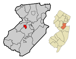 Census Bureau map of Milltown, New Jersey
Coordinates: 40°27′00″N 74°26′04″W / 40.45°N 74.43444°WCoordinates: 40°27′00″N 74°26′04″W / 40.45°N 74.43444°W Country United States State New Jersey County Middlesex Incorporated January 29, 1889 Government – Type Borough (New Jersey) – Mayor Gloria M. Bradford (term ends 2011)[1] Area[2] – Total 1.60 sq mi (4.2 km2) – Land 1.57 sq mi (4.1 km2) – Water 0.03 sq mi (0.1 km2) 1.88% Elevation[3] 43 ft (13 m) Population (2010 Census)[4] – Total 6,893 – Density 4,308.1/sq mi (1,641.2/km2) Time zone Eastern (EST) (UTC-5) – Summer (DST) EDT (UTC-4) ZIP code 08850[5] Area code(s) 732/848 FIPS code 34-46620[6][7] GNIS feature ID 0885303[8] Website http://www.milltownnj.org Milltown is a Borough in Middlesex County, New Jersey, United States. As of the 2010 United States Census, the borough population was 6,893.[4]
Milltown was incorporated as a borough by an Act of the New Jersey Legislature on January 29, 1889, from portions of North Brunswick Township, based on the results of a referendum held three day earlier. The borough was reincorporated by resolution of the borough council on May 2, 1896. A portion of East Brunswick Township was annexed in 1902.[9]
As of the 2000 Census, the center of population for New Jersey was located in Milltown, at Milltown Road, just east of the New Jersey Turnpike (see map of location).[10]
The groundbreaking anxiolytic and sedative drug Miltown (meprobamate), which first came to market in the mid-1950s, was named after the town of Milltown.[11]
Contents
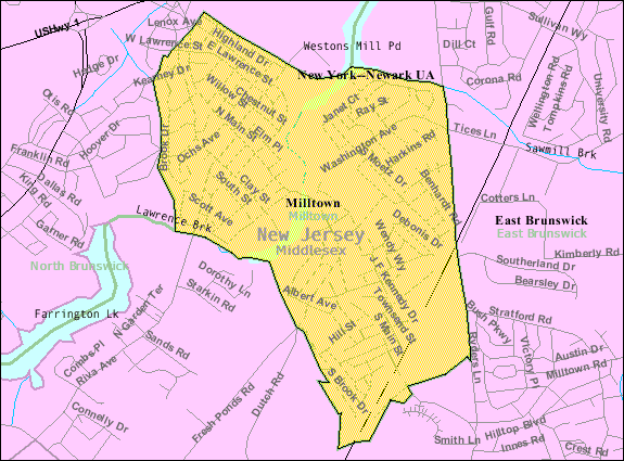
Geography
Milltown is located at 40°27′09″N 74°26′17″W / 40.452538°N 74.438020°W (40.452538, -74.438020).[12]
According to the United States Census Bureau, the borough has a total area of 1.60 square miles (4.1 km2), of which, 1.57 square miles (4.1 km2) of it is land and 0.03 square miles (0.078 km2) of it (1.88%) is water.[2]
Milltown borders North Brunswick to the west, and East Brunswick Township to the east.
The Lawrence Brook, a tributary of the Raritan River, flows through the borough after exiting the Farrington Lake. The dam, under Main Street creates a reservoir, the Mill Pond.
History
Long before the arrival of the first Europeans, the Lenape had established settlements along the Lawrence Brook. The discovery of many artifacts in the area above today's municipal building (now a small County Park) suggests the presence of an Indian settlement.[13] In 1678 Thomas Lawrence, a New York baker, acquired a large area around the Lawrence brook, which likely included today's Milltown. The Lawrence Brook was then called Piscopeek (and on later maps, Lawrence's brook). The names and marks of several Indians (Quemareck, Quesiacs, Isarick, Metapis, Peckawan and Turantaca) appear on the bill of sale.[14] In 1769, Fulcard Van Nordstrand advertised the sale of a large gristmill on the bank of Lawrence Brook. It would soon be called Lawrence Brook Mill.[15]
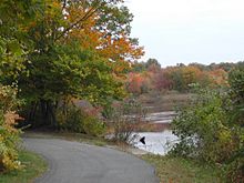 The Mill Pond path
Controversy
In March 2010, the Milltown City Council voted against changing the name of Petain Avenue, citing the difficulties that the street's residents would endure if the name changed.[16][17] Petain Avenue is named for Philippe Pétain, a French World War I general who later became the leader of the Vichy France government during World War II. The Vichy Regime willfully collaborated with Nazi Germany, taking state action against "undesirables," including Jews, Protestants, gays, gypsies, and left-wing activists. In total, the Vichy government participated in the deportation of 76,000 Jews to German extermination camps, although this number varies depending on the account; only 2,500 survived the war.[18] After the War, Petain was charged with perjury and sentenced to death by firing squad. Every city in France has since changed the name of streets formerly known as Petain.[19]
Demographics
Historical populations Census Pop. %± 1930 2,994 — 1940 3,515 17.4% 1950 3,786 7.7% 1960 5,435 43.6% 1970 6,470 19.0% 1980 7,136 10.3% 1990 6,968 −2.4% 2000 7,000 0.5% 2010 6,893 −1.5% Population sources:
1930-1990[20] 2000[21] 2010[4][22]As of the 2000 Census, Milltown had a population of 6,893. The median age was 41.6. The racial and ethnic composition of the population was 92.4% White, 1.2% Black or African American, 0.1% Native American, 3.4% Asian, 1.6% some other race and 1.2% reporting two or more races. 6.5% were Hispanic or Latino of any race.[22]
As of the census[6] of 2000, there were 7,000 people, 2,627 households, and 1,943 families residing in the borough. The population density was 4,452.0 people per square mile (1,721.5/km2). There were 2,670 housing units at an average density of 1,698.1 per square mile (656.6/km2). The racial makeup of the borough was 93.86% White, 0.76% African American, 0.16% Native American, 3.07% Asian, 1.16% from other races, and 1.00% from two or more races. Hispanic or Latino of any race were 3.73% of the population.[21]
There were 2,627 households out of which 31.7% had children under the age of 18 living with them, 60.9% were married couples living together, 9.9% had a female householder with no husband present, and 26.0% were non-families. 21.4% of all households were made up of individuals and 9.7% had someone living alone who was 65 years of age or older. The average household size was 2.66 and the average family size was 3.12.[21]
In the borough the population was spread out with 22.9% under the age of 18, 6.8% from 18 to 24, 29.5% from 25 to 44, 25.1% from 45 to 64, and 15.7% who were 65 years of age or older. The median age was 40 years. For every 100 females there were 93.2 males. For every 100 females age 18 and over, there were 90.2 males.[21]
The median income for a household in the borough was $68,429, and the median income for a family was $77,869. Males had a median income of $50,338 versus $38,220 for females. The per capita income for the borough was $29,996. About 1.3% of families and 2.3% of the population were below the poverty line, including 3.3% of those under age 18 and 1.3% of those age 65 or over.[21]
As of the Census Bureau's 2005-2009 American Community Survey, median income for a household was $92,804 and the median income for a family was $106,133. Males had a median income of $50,338 versus $38,220 for females. The per capita income for the borough was $33,904.[23]
Government
Local government
Milltown is governed under the Borough form of government by a Mayor and a six-member Borough Council. The Mayor is directly elected by the voters to serve a four-year term of office. Members of the Borough Council serve three-year terms in office on a staggered basis, with two seats coming up for election each year.
As of 2011[update], the Mayor of Milltown Borough is Gloria M. Bradford. Members of the Milltown Borough Council (with their chairmanship listed in parentheses) are Council President Lawrence Citro (Public Safety), Ronald Dixon (Public Works & Recycling), Gary Holsten (Utilities), George Murray (Parks & Recreation), Robert Owens (Finance, Planning & Administration) and Richard Ryan (Environmental, Health & Social Services).[24]
Federal, state and county representation
Milltown is in the 12th Congressional district and is part of New Jersey's 17th state legislative district.[25] The legislative district was kept unchanged by the New Jersey Apportionment Commission based on the results of the 2010 Census.[4]
New Jersey's Twelfth Congressional District is represented by Rush D. Holt, Jr. (D, Hopewell Township).[26] New Jersey is represented in the United States Senate by Frank Lautenberg (D, Cliffside Park) and Bob Menendez (D, Hoboken).
17th Legislative District of the New Jersey Legislature, which is represented in the New Jersey Senate by Bob Smith (D, Piscataway) and in the New Jersey General Assembly by Upendra J. Chivukula (D, Somerset) and Joseph V. Egan (D, New Brunswick).[27] The Governor of New Jersey is Chris Christie (R, Mendham).[28] The Lieutenant Governor of New Jersey is Kim Guadagno (R, Monmouth Beach).[29]
Middlesex County is governed by a Board of Chosen Freeholders, whose seven members are elected at-large to serve three-year terms of office on a staggered basis, with two or three seats coming up for election each year. As of 2010 , Middlesex County's Freeholders are Freeholder Director Christopher D. Rafano (South River), Freeholder Deputy Director Ronald G. Rios (Carteret), Carol Barrett Ballante (Monmouth Junction), Stephen J. "Pete" Dalina (Fords), H. James Polos (Highland Park), Mildred Scott (Piscataway) and Blanquita B. Valenti (New Brunswick). Constitutional officers are County Clerk Elaine M. Flynn (Old Bridge Township), Sheriff Mildred S. Scott (Piscataway) and Surrogate Kevin J. Hoagland (New Brunswick).[30]
Education
Students in public school for grades K-8 attend the Milltown Public Schools. Schools in the district (with 2009-10 enrollment data from the National Center for Education Statistics[31]) are Parkview School (PreK-3, 277 students) and Joyce Kilmer School (4-8, 400 students).
For grades 9 - 12, public school students attend Spotswood High School in Spotswood as part of a sending/receiving relationship with the Spotswood Public Schools.[32]
There is also a Catholic K-8 school Our Lady of Lourdes on Cleveland Avenue, which operates under the auspices of the Roman Catholic Diocese of Metuchen.[33]
Transportation
The Raritan River Railroad ran through Milltown, but is now defunct along this part of the line. The track and freight station still remain.
County Route 617 (Ryders Lane) is a major artery serving the borough along the eastern border. The New Jersey Turnpike pass through for about a mile, but the closest interchange is in neighboring East Brunswick Township. Also, U.S. 1 is outside in neighboring North Brunswick.
Notable residents
Notable current and former residents of Milltown include:
- David Kikoski (born 1961), jazz pianist.[34]
- Danny Pintauro (born 1976), actor who got started as a child actor on the television soap opera As the World Turns, and in the movie Cujo, and came to prominence on the television series Who's the Boss?.[35]
- Peter Plantec (born 1943),writer,digital artist and software designer.[36]
References
- ^ 2011 New Jersey Mayors Directory, New Jersey Department of Community Affairs. Accessed October 26, 2011.
- ^ a b GCT-PH1. Population, Housing Units, Area, and Density: 2000 for Middlesex County, New Jersey -- County Subdivision and Place, United States Census Bureau. Accessed October 26, 2011.
- ^ U.S. Geological Survey Geographic Names Information System: Borough of Milltown, Geographic Names Information System, accessed January 4, 2008.
- ^ a b c d 2011 Apportionment Redistricting: Municipalities sorted alphabetically, New Jersey Department of State, p. 7. Accessed October 26, 2011.
- ^ Look Up a ZIP Code, United States Postal Service. Accessed October 26,2011.
- ^ a b "American FactFinder". United States Census Bureau. http://factfinder.census.gov. Retrieved 2008-01-31.
- ^ A Cure for the Common Codes: New Jersey, Missouri Census Data Center. Accessed July 14, 2008.
- ^ "US Board on Geographic Names". United States Geological Survey. 2007-10-25. http://geonames.usgs.gov. Retrieved 2008-01-31.
- ^ "The Story of New Jersey's Civil Boundaries: 1606-1968", John P. Snyder, Bureau of Geology and Topography; Trenton, New Jersey; 1969. p. 171.
- ^ Population and Population Centers by State: 2000, accessed November 16, 2006.
- ^ via Los Angeles Times. "Frank Berger, leader of mood-drug movement, dies", Newsday, March 23, 2008. Accessed April 2, 2008. "He and his colleagues made a short film about the effects of the drug on rhesus monkeys, which created enough interest that Wallace, a subsidiary of Carter Products, brought it to market in May 1955, naming it 'Miltown' after the nearby village of Milltown, N.J."
- ^ "US Gazetteer files: 2010, 2000, and 1990". United States Census Bureau. 2011-02-12. http://www.census.gov/geo/www/gazetteer/gazette.html. Retrieved 2011-04-23.
- ^ Luery, H Rodney, The Story of Milltown, A.S. Barnes, ISBN 0498079600 / 9780498079603 / 0-498-07960-0
- ^ Source : Indian Bill of sale - 1678 (New Jersey State Museum, Trenton).
- ^ History of the Mill, Borough of Milltown. Accessed October 26, 2011.
- ^ Applebome, Peter. "A Local Street and a Lesson in History", The New York Times, March 7, 2010. Accessed October 26, 2011. "Just ask local officials, aggrieved residents of a neighboring town and the folks on Petain Avenue, a tiny, two-house side street in this placid central New Jersey borough. All have suddenly had to confront the legacy of the French World War I war hero and World War II Nazi collaborator, for whom the street is named, and the balance between the burdens of the past and the demands of living in the present."
- ^ Chang, Kathy. "Milltown officials debate Petain street name issue ", East Brunswick Sentinel, March 18, 2010. Accessed October 26, 2011. "No one disputes the facts surrounding the street’s namesake, Philippe Pétain, and his link to the Nazis during World War II. However, Mayor Gloria Bradford and Borough Council members said they have been stymied because of the “hardship” that residents who live on the street would have to endure if the street name is changed."
- ^ Jean-Luc Einaudi and Maurice Rajsfus (2001), op.cit., p.17
- ^ Tagliabue, John. "Both Hero and Traitor, but No Longer on the Map", The New York Times, January 2, 2011. Accessed June 27, 2011. "After World War I, virtually every town in France had its Rue or Avenue Pétain. So vast was his fame that a dozen or so towns and cities in the United States also named streets for him. But when the signs here change this month, the last street in France bearing his name will have disappeared."
- ^ New Jersey Resident Population by Municipality: 1930 - 1990, Workforce New Jersey Public Information Network, backed up by the Internet Archive as of May 2, 2009. Accessed October 26, 2011.
- ^ a b c d e Census 2000 Demographic Profile Highlights for Milltown borough, New Jersey, United States Census Bureau. Accessed October 26, 2011.
- ^ a b Profile of General Demographic Characteristics: 2010 for Milltown borough, New Jersey Department of Labor and Workforce Development. Accessed October 26, 2011.
- ^ 2005-2009 American Community Survey 5-Year Estimates Data Profile Highlights for Milltown borough, New Jersey, United States Census Bureau. Accessed October 26, 2011.
- ^ Borough of Milltown - Municipal, Milltown Borough. Accessed March 25, 2011.
- ^ 2011 New Jersey Citizen's Guide to Government, New Jersey League of Women Voters, p. 61. Accessed October 26, 2011.
- ^ Municipalities, Congressman Rush D. Holt, Jr. Accessed June 29, 2008.
- ^ "Legislative Roster: 2010-2011 Session". New Jersey Legislature. http://www.njleg.state.nj.us/members/roster.asp. Retrieved 2010-07-01.
- ^ "About the Governor". New Jersey. http://www.nj.gov/governor/about/. Retrieved 2010-01-21.
- ^ "About the Lieutenant Governor". New Jersey. http://www.nj.gov/governor/lt/. Retrieved 2010-01-21.
- ^ Elected County Officials, Middlesex County, New Jersey. Accessed January 5, 2011.
- ^ Data for the Milltown Public Schools, National Center for Education Statistics. Accessed June 27, 2011.
- ^ Milltown Fact Sheet, Joyce Kilmer School. Accessed March 25, 2011. "Through a formal send–receive contract, approved by the Commissioner of Education, our high school students are sent on a tuition basis to Spotswood High School. Our 2010–2011 budget of $14.7 million supports Parkview School and Joyce Kilmer School, as well as the tuition for students attending Spotswood High School."
- ^ School Directory, Roman Catholic Diocese of Metuchen. Accessed October 26, 2011.
- ^ Biography, DavidKikosky.com. Accessed April 8, 2007. "David Kikoski was born on October 16, 1965 in Milltown, New Jersey."
- ^ Danny Pintauro profile, TV.com, accessed April 8, 2007. "Daniel John Pintauro was born on January 6, 1976 in Milltown, New Jersey."
- ^ Petersen, Tara. "Sons of Milltown return to reminisce", Sentinel, June 10, 2004. Accessed April 9, 2011. "'This is the best place in the world. I’ve never met anybody with a childhood as great as mine,' Peter Plantec, 61, said. Plantec, who lived in Milltown from 1944 to 1967, traveled from Aspen, Colo., to attend.
External links
- Borough of Milltown website
- Milltown Public Schools
- Milltown Public Schools's 2009–10 School Report Card from the New Jersey Department of Education
- Data for the Milltown Public Schools, National Center for Education Statistics
Municipalities and communities of Middlesex County, New Jersey Cities 
Boroughs Carteret | Dunellen | Helmetta | Highland Park | Jamesburg | Metuchen | Middlesex | Milltown | Sayreville | South Plainfield | South River | Spotswood
Townships Cranbury | East Brunswick | Edison | Monroe | North Brunswick | Old Bridge | Piscataway | Plainsboro | South Brunswick | Woodbridge
CDPs Avenel | Brownville | Clearbrook Park | Colonia | Concordia | Cranbury | Dayton | Fords | Heathcote | Iselin | Kendall Park | Kingston | Laurence Harbor | Madison Park | Monmouth Junction | Old Bridge | Plainsboro Center | Port Reading | Princeton Meadows | Rossmoor | Sewaren | Society Hill | Whittingham | Woodbridge
Communities Bonhamtown | Browntown | Deans | Franklin Park | Hopelawn | Keasbey | Menlo Park Terrace | Parlin | Raritan Landing
Categories:- Boroughs in Middlesex County, New Jersey
- Populated places established in 1889


Wikimedia Foundation. 2010.