- Mount Hope Bridge
-
Mount Hope Bridge 
Mount Hope Bridge linking Portsmouth, RI, to Bristol, RICarries 2 lanes of RI 114 Crosses Mount Hope Bay Locale Portsmouth, Rhode Island and Bristol, Rhode Island Maintained by Rhode Island Turnpike and Bridge Authority Design Suspension bridge Total length 6,130 feet (1,868 m) Width 28 ft (9 m) Height 285 feet (87 m) Longest span 1,200 feet (366 m) Clearance below 135 feet (41 m) Construction begin December 1, 1927 Opened October 24, 1929 Coordinates Mount Hope Bridge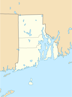

Coordinates: 41°38′23.6″N 71°15′29.5″W / 41.639889°N 71.258194°WCoordinates: 41°38′23.6″N 71°15′29.5″W / 41.639889°N 71.258194°W NRHP Reference#: 76000038 Added to NRHP: 1976 The Mount Hope Bridge is a two-lane suspension bridge spanning the Mount Hope Bay in eastern Rhode Island, at one of the narrowest gaps in Narragansett Bay. The bridge connects the Rhode Island towns of Portsmouth and Bristol, and is part of Route 114. Its towers are 285 feet (87 m) tall, the length of the main span is 1,200 feet (366 m) and it offers 135 feet (41 m) of clearance over high water. The total length of the bridge is 6,130 feet (1,868 m).
Contents
History
Before the bridge was built, a ferry operated between Bristol and Portsmouth. The 1855 Bristol Ferry Light still remains at the base of the bridge. The Mount Hope Bridge was originally proposed in 1920. After a few years of resistance from the Rhode Island General Assembly, the New Hope Bridge Company was incorporated in 1927. Using a design by Robinson & Steinman, construction began on December 1, 1927.
Four months before it was to open, serious structural problems were discovered, forcing the contractor to disassemble and reassemble portions of the bridge.
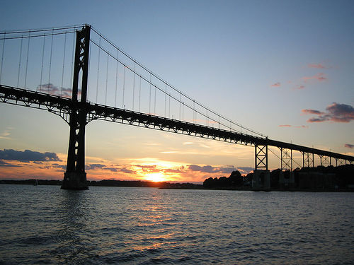
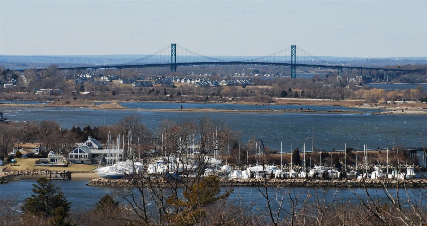
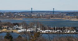 View of Mount Hope Bridge
On October 24, 1929, about five months behind schedule, the $5,000,000 bridge was opened to traffic. It was owned by the Mount Hope Bridge Company as a private toll bridge, with the initial toll costing 60 cents one way, and $1 for a round-trip. By 1931, the Bridge company went bankrupt, and Rudolf F. Haffenreffer, a prominent local brewer, acquired the bridge in receivership.[1]
It remained the longest suspension bridge in New England for 40 years, until the Claiborne Pell Bridge opened a few miles to the south in Newport, Rhode Island.
In 1971, the Mount Hope Bridge was considered for inclusion as part of the never-built Interstate 895. This plan would have required the construction of a parallel span, and the entire I-895 plan was eventually dropped due to community opposition throughout the affected areas of Rhode Island.
Since 1976, the Mount Hope Bridge has been listed with the National Register of Historic Places (Structure #76000038).
It underwent more than $15 million in renovations between 1998 and 2004.
Bicycles are permitted on this bridge, but bicyclists are advised to use extreme caution.[2] The bridge also has narrow sidewalks on both sides,[3] but pedestrians are strictly prohibited from using the bridge.
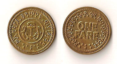
Bridge tokens
In 1954, with the company in receivership, the Mount Hope Bridge was purchased by the State of Rhode Island. The bridge's toll was eventually reduced from 60 cents to 30 cents for a one-way trip. It was finally discontinued in 1998, after calculations indicated that the toll was not high enough to cover the cost of collecting it.
-

Mount Hope Bridge one fare token, front and back
-

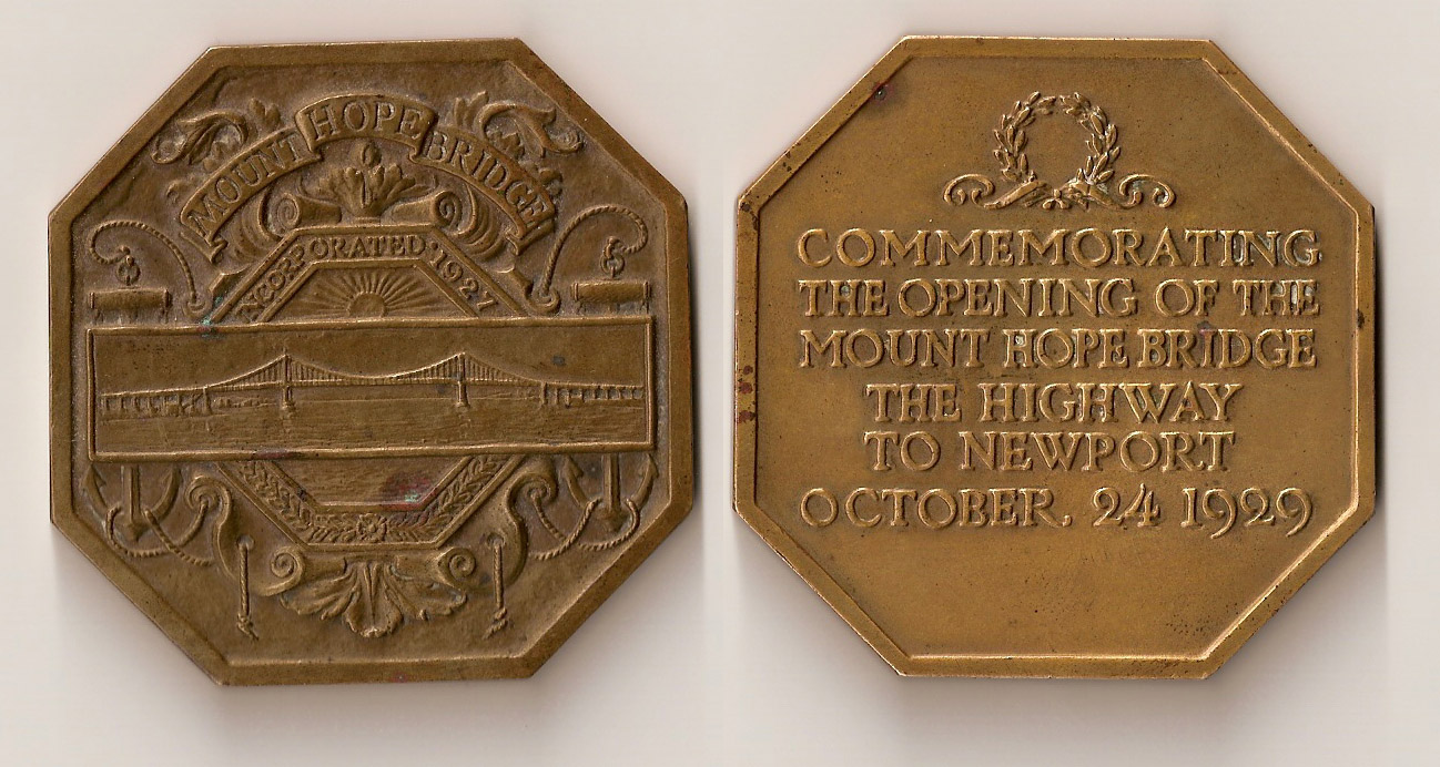
Commemorative medal (front and back) struck in 1929, honoring the opening of the Mount Hope Bridge
References
- ^ Mount Hope Farm
- ^ Bike Rhode Island and Guide to Bicycling in the Ocean State 2005-2006, Rhode Island Department of Transportation
- ^ Steve Anderson's Bostonroads.com: Mount Hope Bridge (RI 114)
External links
- Photograph of Mount Hope Bridge by Kathleen Murtagh
- Mount Hope Bridge page on BostonRoads.com
- Mount Hope Bridge at Structurae
Narragansett Bay Islands Aquidneck Island · Conanicut Island · Prudence Island · Patience Island · Hog Island · Dutch Island · Coaster's Harbor Island · Cornelius Island · Despair Island · Dyer Island · Fox Island · Goat Island · Gould Island · Greene Island · Hope Island · Lime Rock · Rabbit Island · Rock Island · Rose Island · Starvegoat Island · Whale Rock
Major rivers Cities & towns Providence · Newport · Cranston · Warwick · East Providence · Barrington · Bristol · East Greenwich · Jamestown · Middletown · Narragansett · North Kingstown . Portsmouth · WarrenBridges Newport Bridge · Jamestown Verrazzano Bridge · Mount Hope Bridge · Sakonnet River Bridge · Jamestown BridgeU.S. National Register of Historic Places Topics Lists by states Alabama • Alaska • Arizona • Arkansas • California • Colorado • Connecticut • Delaware • Florida • Georgia • Hawaii • Idaho • Illinois • Indiana • Iowa • Kansas • Kentucky • Louisiana • Maine • Maryland • Massachusetts • Michigan • Minnesota • Mississippi • Missouri • Montana • Nebraska • Nevada • New Hampshire • New Jersey • New Mexico • New York • North Carolina • North Dakota • Ohio • Oklahoma • Oregon • Pennsylvania • Rhode Island • South Carolina • South Dakota • Tennessee • Texas • Utah • Vermont • Virginia • Washington • West Virginia • Wisconsin • WyomingLists by territories Lists by associated states Other  Category:National Register of Historic Places •
  Portal:National Register of Historic PlacesCategories:
- Towers in Rhode Island
- Transportation in Bristol County, Rhode Island
- Transportation in Newport County, Rhode Island
- Suspension bridges in the United States
- Bridges on the National Register of Historic Places in Rhode Island
- Bridges completed in 1929
- Former toll bridges in the United States
- Buildings and structures in Newport County, Rhode Island
- Road bridges in Rhode Island
-

Wikimedia Foundation. 2010.