- Jamestown Verrazzano Bridge
Infobox Bridge
bridge_name = Jamestown Verrazzano Bridge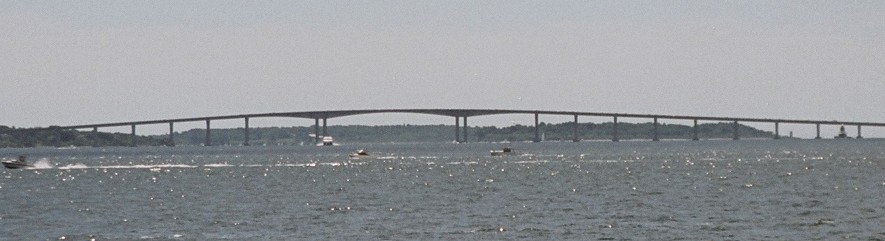
caption = The Jamestown Verrazzano Bridge in July 2007, after the demolition of the original Jamestown Bridge
official_name =
carries =
crosses = West Passage ofNarragansett Bay
locale =North Kingstown, Rhode Island toJamestown, Rhode Island
maint =
id =
designer =
design = post-tensioned, double-cellconcrete box girder
material = concrete
spans =
pierswater =
mainspan =
length = convert|7350|ft
width =
height =
load =
clearance =
below =
traffic =
begin =
complete =
open = 1992
closed =
toll =
map_cue =
map_
map_text = Approximate location
map_width = 180px
coordinates = coord|41.529810|N|71.411039|W|display=inline,title
lat =
long =The Jamestown Verrazzano Bridge (often misspelled Jamestown-Verrazano Bridge) spans the West Passage of
Narragansett Bay inRhode Island ,United States . It is part of Route 138 and is part of the route toNewport, Rhode Island for traffic heading northbound from Interstate 95.The bridge is a post-tensioned, double-cell
concrete box girder bridge with four travel lanes separated by a concreteJersey barrier (the original bridge was dangerous with two undivided lanes). The total length of the bridge is 7,350 ft (2,240 m) and links the towns ofNorth Kingstown, Rhode Island and the island town ofJamestown, Rhode Island .Bicycles are not currently permitted on this bridge as a part of a
limited access highway , butRhode Island Public Transit Authority bus #64 has bike racks without Sunday service. [ [http://www.dot.state.ri.us/bikeri/ Bike Rhode Island] and Guide to Bicycling in the Ocean State 2005-2006,Rhode Island Department of Transportation ]History
The bridge was completed in 1992 and was built alongside the two lane bridge that had served the same route since 1940. The original
Jamestown Bridge was demolished in April 2006.References
External links
* [http://www.bostonroads.com/crossings/jamestown/ Steve Anderson's Bostonroads.com: Jamestown-Verrazano Bridge (RI 138)]
* [http://www.pbworld.com/news_events/publications/network/Issue_57/57_22_abrahamsm_inspectionjamestown.asp Inspection and Maintenance of the bridge]
* [http://www.artinruins.com/arch/rip/jamestown/ Bridge history]
Wikimedia Foundation. 2010.