- Middletown, Rhode Island
-
Middletown, Rhode Island — Town — St. George's School, Middletown, Rhode Island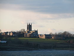 Location of Middletown in Newport County, Rhode Island
Coordinates: 41°30′42″N 71°17′12″W / 41.51167°N 71.28667°W Country United States State Rhode Island County Newport Incorporated 1743 Area - Total 14.9 sq mi (38.7 km2) - Land 13.0 sq mi (33.6 km2) - Water 2.0 sq mi (5.1 km2) Elevation 154 ft (47 m) Population (2010) - Total 16,150 - Density 1,242.3/sq mi (480.7/km2) Time zone Eastern (EST) (UTC-5) - Summer (DST) EDT (UTC-4) ZIP codes 02840, 02842 Area code(s) 401 FIPS code 44-45460[1] GNIS feature ID 1220063[2] Middletown is a town in Newport County, Rhode Island, United States. The population was 16,150 at the 2010 census. It lies to the south of Portsmouth and to the north of Newport on Aquidneck Island, hence the name "Middletown."
Contents
Geography
According to the United States Census Bureau, the town has a total area of 14.9 square miles (38.7 km²), of which 13.0 square miles (33.6 km²) is land and 2.0 square miles (5.1 km²)(13.18%) is water. Middletown is known as the "farming community" of Aquidneck Island, today about 45% of the town is farm land, 25% is wooded, and about 30% is developed of its 14.9 square miles (39 km2). Most of the developed land is located towards the southern part of the town near Newport while the rural area is towards the North near Portsmouth. Middletown also has several beaches.
History
Various issues including unjust taxation and a growing population caused the Newport freeholders living in the northern section of Newport to petition the general assembly for independence. As a result of the petition, the land that Middletown occupies was set apart in 1731. The town was incorporated in 1743.
During the 1980s, large sections of East Main Road and West Main Road running through Middletown began to be commercialized, and by the late 1990s, the area had become Aquidneck Island's central business district.
Government
The town is governed by a seven-member town council, elected at-large in partisan elections. Executive authority is vested in an appointed town administrator (on the council–manager model). The town also elects a non-partisan school committee.
Middletown forms part of Rhode Island's 1st congressional district, represented by Democrat David Cicilline. At the state level, Middletown is part of one state senate and three state house districts. The 12th Rhode Island Senate district, which also includes parts of Newport, Little Compton and Tiverton, is held by Democrat Louis P. DiPalma. In the Rhode Island House of Representatives, Middletown forms part of the 72nd, 73rd and 74th districts. The 72nd, which also includes portions of Newport and Portsmouth, is represented by Republican Daniel Reilly. The 73rd, which is predominantly Newport, is held by Democrat Russell Jackson. The 74th, shared between Middletown and Jamestown, is represented by Democrat Deb Ruggiero.
Demographics
As of the census[1] of 2000, there were 17,334 people, 6,993 households, and 4,643 families residing in the town. The population density was 1,335.4 people per square mile (515.6/km²). There were 7,603 housing units at an average density of 585.7 per square mile (226.2/km²). The racial makeup of the town was 89.12% White, 2.72% African American, 2.36% Native American, 1.18% Asian, 1.11% Pacific Islander, 1.07% from other races, and 2.43% from two or more races. Hispanic or Latino of any race were 2.93% of the population.
There were 6,993 households out of which 32.9% had children under the age of 18 living with them, 53.9% were married couples living together, 9.8% had a female householder with no husband present, and 33.6% were non-families. 28.7% of all households were made up of individuals and 10.9% had someone living alone who was 65 years of age or older. The average household size was 2.43 and the average family size was 3.01.
In the town the population was spread out with 25.0% under the age of 18, 6.6% from 18 to 24, 30.9% from 25 to 44, 22.6% from 45 to 64, and 14.9% who were 65 years of age or older. The median age was 38 years. For every 100 females there were 94.8 males. For every 100 females age 18 and over, there were 89.7 males.
The median income for a household in the town was $51,075, and the median income for a family was $57,322. Males had a median income of $41,778 versus $27,229 for females. The per capita income for the town was $25,857. About 3.7% of families and 5.0% of the population were below the poverty line, including 6.2% of those under age 18 and 4.7% of those age 65 or over.
Notable residents
Nicolas Cage – In August 2007, Cage purchased a home in Middletown titled the "Grey Craig." The 24,000-square-foot (2,200 m2), brick-and-stone country home, on 26 secluded acres, has 12 bedrooms, 10 full bathrooms and sweeping views of the Atlantic Ocean from its spot neighbouring the Norman Bird Sanctuary Wildlife Refuge. The sale ranks among the state’s most expensive residential purchases, eclipsed by the $17.15 million sale last December of the Miramar mansion on Bellevue Avenue in Newport.
Charlie Day of the television show It's Always Sunny in Philadelphia spent his childhood in the 1970s in Middletown.
Transportation
Newport State Airport, a public-use general aviation airport and the only airport on Aquidneck Island, is located in Middletown.
West Main Road (RI-114) and East Main Road (RI-138) are the main roads running north-south through Middletown.
Sports
Middletown is home to St Columba's Cricket Club, which hosts an annual cricket tournament for teams throughout the New England area. The Newport National Golf Club is located in Middletown. The town is also home to the Middletown Islanders Hockey, Football, Baseball, Volleyball, and Lacrosse teams. They also are involved with Pop Warner football and cheer-leading along with many other cities throughout New England. More known as a Middle School football teams, Pop Warner hosts from very young ages and separates them by age.
- Kids ages 6–8: Mighty Mights
- Kids ages 9&10: Junior Pee Wee
- Kids ages 11&12: Pee Wee
- Kids ages 13&14: Midget
Schools
As of September 2009, The Middletown Public School District will consist of 4 schools serving pre-kindergarten through 12th Grade. They are Aquidneck Elementary School (Grades PreK – 3), Forest Avenue Elementary School (Grades K – 3), Joseph H. Gaudet Middle School (Grades 4 – 8) and Middletown High School (Grades 9 – 12). Starting in September 2009, all fourth grade students will attend Joseph H. Gaudet Middle School. John F. Kennedy, former elementary school, will be closed at the end of the 2008–2009 school year due to budget cuts. Middletown is also home to private schools, including All Saints Academy (Grades K-8) and St. George's School (Grades 9–12).
Historic Sites in Middletown
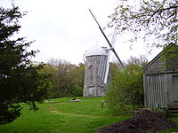
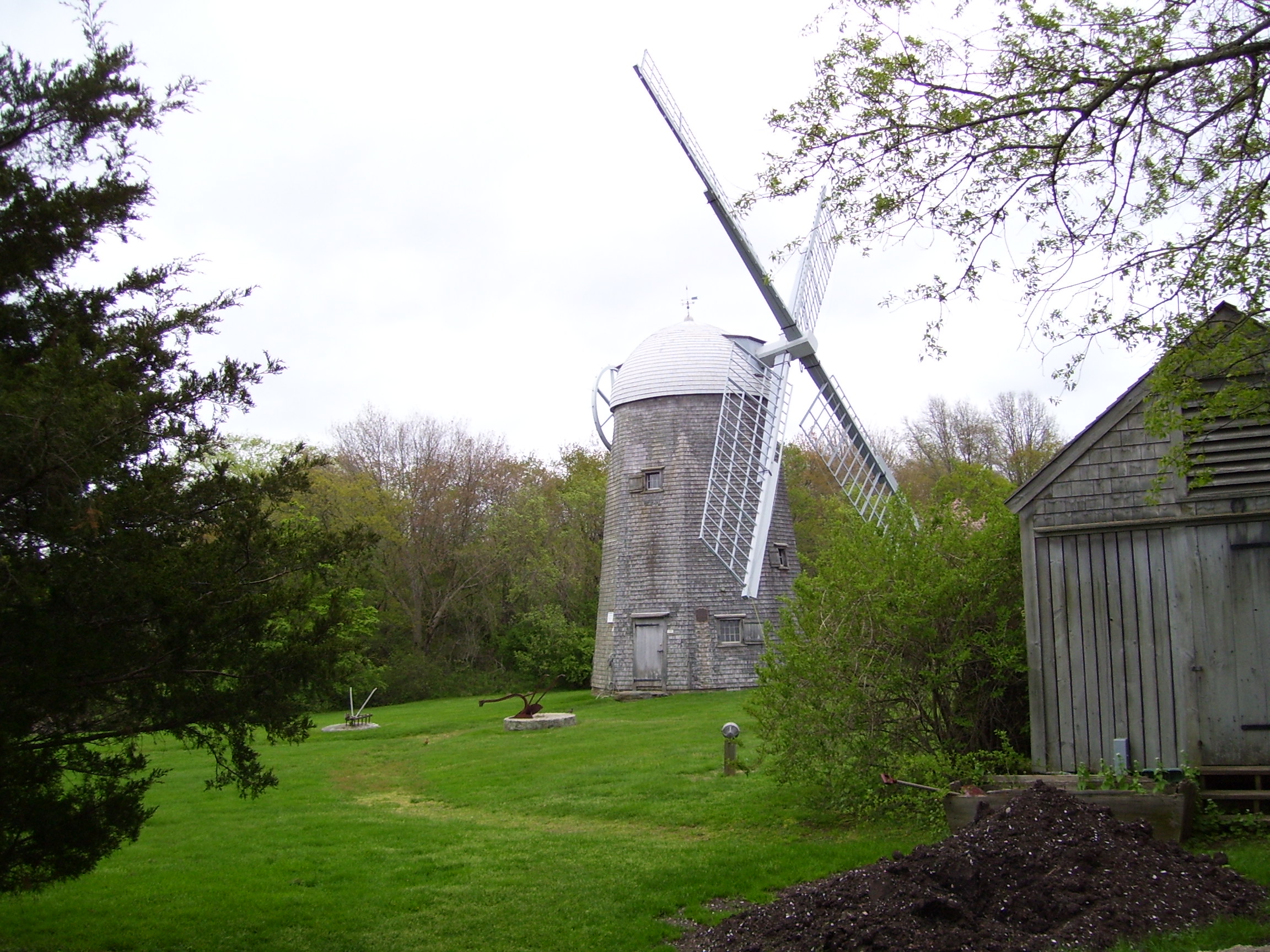
- Boyd's Windmill, built 1810
- Bailey Farm, built 1838
- Clambake Club of Newport, built in 1895
- Gardiner Pond Shell Midden
- Hamilton Hoppin House, built in 1856
- Lyman C. Joseph House, built 1882
- Paradise School, built 1875
- Prescott Farm, ca. 1715
- Whitehall (Rhode Island), built 1729
- Witherbee School, built 1900
References
- ^ a b "American FactFinder". United States Census Bureau. http://factfinder.census.gov. Retrieved 2008-01-31.
- ^ "US Board on Geographic Names". United States Geological Survey. 2007-10-25. http://geonames.usgs.gov. Retrieved 2008-01-31.
External links
- Town of Middletown, Rhode Island
- Middletown Historical Society
- Middletown Beaches rated among the Top 10 New England Beaches
Municipalities and communities of Newport County, Rhode Island City 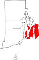
Towns Jamestown | Little Compton | Middletown | Portsmouth | Tiverton
CDPs  State of Rhode Island and Providence Plantations
Providence (capital) Topics Culture | Delegations | Geography | Government | History | Thirteen Colonies | Colonial Colleges | Images | Narragansett Indian Tribe | People | Visitor attractions | State symbols
Regions Counties: Bristol | Kent | Newport | Providence | Washington | Geographic: Blackstone Valley | Block Island
Cities Central Falls | Cranston | East Providence | Newport | Pawtucket | Providence | Warwick | Woonsocket
Towns Barrington | Bristol | Burrillville | Charlestown | Coventry | Cumberland | East Greenwich | Exeter | Foster | Glocester | Hopkinton | Jamestown | Johnston | Lincoln | Little Compton | Middletown | Narragansett | New Shoreham (Block Island) | North Kingstown | North Providence | North Smithfield | Portsmouth | Richmond | Scituate | Smithfield | South Kingstown | Tiverton | Warren | Westerly | West Greenwich | West Warwick
Narragansett Bay Islands Aquidneck Island · Conanicut Island · Prudence Island · Patience Island · Hog Island · Dutch Island · Coaster's Harbor Island · Cornelius Island · Despair Island · Dyer Island · Fox Island · Goat Island · Gould Island · Greene Island · Hope Island · Lime Rock · Rabbit Island · Rock Island · Rose Island · Starvegoat Island · Whale Rock
Major rivers Cities & towns Providence · Newport · Cranston · Warwick · East Providence · Barrington · Bristol · East Greenwich · Jamestown · Middletown · Narragansett · North Kingstown . Portsmouth · WarrenBridges Coordinates: 41°32′44″N 71°17′29″W / 41.54556°N 71.29139°W
Categories:- Populated places in Newport County, Rhode Island
- Towns in Rhode Island
- Populated coastal places in Rhode Island


Wikimedia Foundation. 2010.