- Murree Tehsil
-
Murree Tehsil — Tehsil — 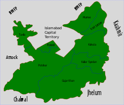
Country  Pakistan
Region Punjab District Rawalpindi District Capital Murree Towns 1 Union councils 15 Government – Nazim – Naib nazim Time zone PST (UTC+5) – Summer (DST) PDT (UTC+6) Murree Tehsil (Urdu: تحصیل مری) is one of the seven Tehsils (i.e sub-divisions) of Rawalpindi District in the Punjab province of Pakistan.
Murree Tehsil is located in the northernmost part of Punjab province where it borders the North West Frontier Province. The hill resort city of Murree is the capital city of this area.
Contents
Administration
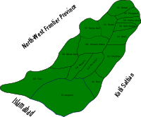 Map showing Administrative subdivisions of Murree Tehsil.
Murree Tehsil is divided into 15 Union Councils these are:[1].
UC Name of Union Uc-49 Murree Urban Uc-51 Dewal Uc-52 Phagwari Uc-53 Potha Sharif Uc-54 Ghel Uc-55 Rawat Uc-56 Sehr Bagla Uc-57 Darya Gali Uc-58 Gora Gali Uc-59 Numble Uc-60 Mussiari Uc-61 Angoori Uc-62 Tret Uc-63 Charhan Uc-64 Ban Note: The UC prefix is used for administration purposes as Rawalpindi District has a total of 90 Union Councils.
History
The British Raj quickened the pulse of the district when it took control of the Murree Hills, but the quiet routine of the ordinary hillman was never seriously interrupted or changed. During the Raj, the hills and valleys of Murree had denser forests than today. It even had a variety of wildlife. It is difficult to say when, where and how the first human dwelling started on Murree hills. From the layman’s point of view, it happened roughly a thousand years back. This assumption is based upon the study of old graves and centuries-old plants found growing in the vicinity. The construction and style of graves and the direction in which they are made also help in determining their age.
According to the 1901 census of India, Murree Tehsil contained 1 town (Murree) and 258 villages, the total population was recorded as 52,303 which was an increase of 14.3% from 1891 - of this 1,463 were literate. The population density was 202.7 per square mile, (total area=258 square miles)[2].
2005 earthquake
During the earthquake of 2005, 40% of houses in Murree tehsil were damaged or destroyed[3]
Tribes
The Dhond Abbasi are the main tribe of the area. The Kethwal Rajputs are the second largest tribe in the area. Their origins lie in Kerman Persia; they travelled eastwards and settled in the hills. The Kethwals are well established in the Charhan, Ghel and Ban areas of Murree (Tehsil). The Dhanyal is the third largest tribe in area. The Jasgam are the fourth largest tribe.
Before the creation of Kotli Sattian as a separate Tehsil from Murree, the Satti tribe was the second largest. Now they form a much smaller proportion of the population of Murree Tehsil, limited mainly to the 'Gehl Sattian' areas and a few groups living in Circle Bakote. Notable Sattis in Murree are: Subedar Aalim Sher Khan Satti and Dafidar Khan Muhammad Satti from Murree's village of Ghel Sattian, who were politically active both pre- and post-independence in their village.
See Also Demography of Rawalpindi District
Murree hills culture
Tribal histories
Shah Wali, also known as Dhoond Khan (from whom the Dhond Abbasi tribe descended), came to Murree in the middle of the 12th century, while Mohazzam Shah, alias Dhanni Pir (from whom the Dhanyal tribe descended), arrived around 1190 from Dhanni, Chakwal. Shah's parents had ruled Multan State for about 190 years and were descended from Alvis, who migrated from Iraq early in the 8th century. Mohazzam Shah supported Shahabuddin Ghouri intermittently to curb the activities of Dogra Rajputs, who were against his leadership. In the 13th century, Mohazzam Shah died fighting against the Hindu Dogra Rajputs, and a separate tribe, Dhanyal, was established. The followers of Mohazzam Shah have made a shrine in his memory on Lehtrar Road, a rural area of Islamabad. All Dhanyals are Alvis and are the descendants of Mohazzam Shah. As he had control over Kashmir, Murree and the surrounding area, the tribe is often called Raja, a king tribe in the locality. Between Dhanyals, they have seven or eight offshoots of the tribe living in Hazara, Islamabad, Rawalpindi, Murree, Bagh Azad Kashmir, Sialkot, Chakwal, Multan and other parts of Pakistan. All are Sunni Muslims. Although they have never participated in the national politics of Pakistan, they are well represented in the Pakistani Armed Forces. Hundreds of Dhanyals sacrificed their lives in World War II and the Indo-Pakistani wars of 1947, 1965 and 1971.
Raja Afzal Khan was famous politician of Satti Tribe he contested lagislative assembly election and was second Chairman of Union Council Chahrian who belongs to Village Dhal his family is head of Dhal valley.
Occupation
Historically, hunger and starvation pushed many people towards the plains or into the army, police and other services. Farming and cattle breeding, the two main occupations of the hill people, have not improved in recent times. Despite the poor returns, farming is the main occupation of the hill people. Farmers in the hilly tracts cannot double-crop, as the climate and irrigation do not give high yields. The average farmer has a holding of four or 5 acres (20,000 m2) land, the small size making farming even more difficult. Cattle breeding is another popular occupation but is not done for profit. Cows are kept to supply milk for household consumption, and bullocks are used to work the plough. Hill cows are hardy but small. An indigenous cow would give a maximum of one seer of milk.
When the Murree Sanatorium developed, a great demand for milk was created. It stimulated the local Zamindars to import milch-kine from other districts. Buffaloes would give two to twelve seers of milk. The profit in milk sales was considerable as milk was sold at the fixed price of one anna per seer. But these windfall profits lasted only until the end of the season. As for large flocks of sheep and goats, they were valued more for providing manure than for milk, meat or skin. In those days, it was a common custom to get the Gujjar herdsmen to assemble their flocks on unsown fields at night. In return, the farmers provided food to the herdsmen. The droppings of sheep and goats fertilised their fields with the best manure available in the hills. Profits from the two main occupations of the hillmen were adequate only if the Zamindars had additional income, but the majority did not. In the absence of an industrial base, local potential was unrealized.
In the past, traditional flour mills (jandar) on waterfalls were used to crush grains. Donkeys are used to carry water from the Choha spring, and the people of Pothawar also use donkeys to carry military equipment and food from Rawalpindi Railway Station to the Murree Hills.
Housing
The rural population of Murree lived in far-flung, small hamlets called dhoks and Grann. Each dhok consisted of at least one to fifty houses. A hamlet comprised fewer than a dozen houses. Each family had its own house and cattle sheds constructed in the middle of its own fields. This isolation was self-desired and voluntary and inspired by their elders. The need for mutual protection often forced the rural population of the countryside to congregate and live in large villages, but the hill people felt no such compulsion. Their priorities lay in two entirely different directions. In the winter, the hill people stayed in their mud houses with fires to stay warm, but during the British Raj, the favoured construction pattern changed to the European style. the sunny bank where the old hoyses which is the property of sheikhs as known as the mohallah sheikhwalla the shees mahal are also the property of sheikhs
Population density
The quality of soil in the hills varies from place to place. The Zamindars therefore may not get the best piece of land in one village alone. The land may be in patches that are scattered at great distances from each other. Hence, the difference between manured and unmanured soil determines their choice of residence. They have distributed their dwellings with the view of readily obtaining manure for a land that appears potentially fertile. Actually, the soil of Murree and Patriata and Karore spurs was considered the best in the tehsil. It was deep and earthy. High-return crops could be grown in it with the help of ample rainfall and a lot of hill manure. When compared with the rich soil of the Punjab plains, it was not as good, but by the hill standards it was satisfactory. For this reason, the Murree, Patriata and Karore spurs are densely populated compared to the other spurs.
Religion
Until 1947, the coexistence of Hindu, Sikh and Muslim populations in the Murree Hills was a significant feature. The great bulk of population in the rural areas was of Sunni Muslims. In a rural population of around 10,000, there were 9,000 Muslims, more than 500 Hindus and nearly 450 Sikhs. When the urban and rural populations are taken together, for every 10,000 people, there were a little more than 1,000 Hindus, nearly 500 Sikhs and approximately 8,500 Muslims. Despite their predominance, the Muslims were not overbearing. They were tolerant of other religions and lived with them in harmony. However, there was a little animosity towards the Sikhs. This was due to the sufferings undergone by the Muslims due to the inaccurate assessment of land revenue under the Sikh rule.
The atmosphere was of mutual tolerance among the three groups. In those days, the Hindu population was more concentrated in Potah Kotli Sattian, Phapprial, Angoori, Kallan Bassan and Deval. This last mentioned village had derived its name from the fact that it had a small temple. In the Hindi language, deval means the abode of gods or a temple. Other Hindu sites were concentrated in Murree Station. At the far end of Lower Bazar, the Hindus had their own locality called Mohallah Shiwala." The sheikh are also the part of the sunny bank is the other home of the sheikhs the sheikhs of dheri spent the vocation of summer there the big names of sheikhs are the sheikh abdul ghani the kani sarkar the famous name the quaid e azam also spent voccation with sheikhs sych as sheikh ;s jalil sheikh haji abdul qadir
References
 Tehsils of Punjab, Pakistan
Bahawalnagar Bahawalpur Bhakkar Chakwal Chiniot Dera Ghazi Khan Faisalabad Gujranwala Gujrat Hafizabad Hafizabad · Pindi BhattianJhang Jhang · Shorkot · Ahmedpur SialJhelum Kasur Khanewal Khushab Lahore Layyah Layyah · Chaubara · Karor · Chowk Azam · FatehpurLodhran Dunya Pur · Kahror Pacca · LodhranMandi Bahauddin Mianwali Multan Multan · Multan Sadar · Shujabad · Jalalpur PirwalaMuzaffargarh Nankana Sahib Narowal Okara Pakpattan Arifwala · PakpattanRahim Yar Khan Rajanpur Jampur · Rajanpur · RojhanRawalpindi Sahiwal Sahiwal · ChichawatniSargodha Sheikhupura Sialkot Toba Tek Singh Vehari Union councils Angoori • Ban • Charhan • Darya Gali • Dewal • Ghel • Ghora Gali • Mussiari • Murree • Numbal • Phagwari • Potha Sharif • Rawat • Sehr Bagla • TretCategories:- Rawalpindi District
- Tehsils of Punjab


Wikimedia Foundation. 2010.