- Gujar Khan Tehsil
Infobox Tehsil Pakistan
tehsil_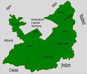
caption = Gujar Khan is located in the south of Rawalpindi District
official_name= Gujar Khan
province= Punjab
district= Rawalpindi
area_total_km2=
census_year= 1998
estimate_year=
census_pop=
estimate_pop=
population_density_km2=
towns= 1
uc= 33
nazim=
naib nazim =
footnotes=
map_size =
map_text =Location withinPakistan Gujar Khan Tehsil, head-quartered at
Gujar Khan , is one of the sevenTehsils (sub-divisions) ofRawalpindi District in the Punjab province ofPakistan . It is administratively subdivided into 33 Union Councils [ [http://www.ecp.gov.pk/content/zttc/townpunjab.htm Zila, Tehsil & Town Councils Membership for Punjab - Election Commission of Pakistan] ] and according to the 1998 census has a population of 493,000 [ [http://www.rawalpindi.gov.pk/ District Government of Rawalpindi] ] .History
The tehsil of Gujar Khan was described in the
Imperial Gazetteer of India , compiled during the first decade of the twentieth century, as follows: [ [http://dsal.uchicago.edu/reference/gazetteer/pager.html?objectid=DS405.1.I34_V12_359.gifGujar Khān, v. 12, p. 353] ]"Southern tahsil of Rawalpindi District, Punjab, lying between 33°4′ and 33°26′ N. and 72°56′ and 73°37′ E., with an area of 567 square miles. It is bounded on the east by the Jhelum river, which cuts it off from Kashmir territory. Except for a low ridge of sandstone hills along the Jhelum, the tahsil consists of a plain intersected by numerous ravines. The population in 1901 was 150,566,compared with 152,455 in 1891. It contains 381 villages, of which Gujar Khan is the head-quarters. The land revenue and cesses in 1903-4 amounted to 2-7 lakhs."
Administration
The tehsil of Gujar Khan is administratively subdivided into 33 tehsils, these are:1.
Bewal - 2.Bhadana - 3.Changa Bangial - 4.Daultala - 5.Devi - 6.Gujar Khan-I - 7.Gujar Khan-II - 8.Gujar Khan-III - 9.Guliana - 10.Gungrila - 11.Jand Mehlo - 12.Jarmot Kalan - 13.Jatli - 14.Jhungle - 15.Kalyam Awan - 16.Kaniat Khalil - 17.Karumb Ilyas - 18.Kauntrila - 19.Kuri Dolal - 20.Mandrah - 21.Manghot - 22.Mankiala Branmma - 23.Matwa - 24.Mohra Noori - 25.Narali - 26.Punjgran Kalan - 27.Qazian - 28.Raman - 29.Sahang - 30.Sui Cheemian - 31.Sukho - 32.Syed Kasran - 33.Thathi Natural resources
Large reserves of oil and gas were discovered in February 2002 at Tobra, about ten kilometres from Gujar Khan. The field is being developed by the Oil and Gas Development Company. The field could produce 1,600 barrels of crude oil daily.cite web| url=http://www.atimes.com/bizasia/DB22Aa01.html| title=Business in Asia| author=Asia Times Online (Holdings) Ltd| accessdate=2007-07-02]
See also
*
Rawalpindi District
*Gujar Khan
*Dohngi Dam References

Wikimedia Foundation. 2010.