- Mayfair
-
For other uses, see Mayfair (disambiguation).
Coordinates: 51°30′32″N 0°08′51″W / 51.508755°N 0.14743°W
Mayfair (originally called The May Fair) is an area of central London, within the City of Westminster.
Contents
History
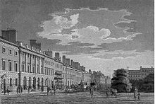
The north side of Grosvenor Square in the 18th or early 19th century. The three houses at the far left form a unified group, but the others on this side are individually designed. Most later London squares would be more uniform.
Mayfair is named after the annual fortnight-long May Fair that took place on the site that is Shepherd Market today (from 1686 until it was banned in that location in 1764). Until 1686, the May Fair was held in Haymarket, and after 1764, it moved to Fair Field in Bow because the well-to-do residents of the area felt the fair lowered the tone of the neighbourhood.[1]
Mayfair was traditionally bordered by Hyde Park to the west, Oxford Street to the north, Piccadilly to the south and Bond Street to the east, although the eastern boundary has been stretched in recent years to Regent Street. The old telephone district of MAYfair (later 629) changed east of Bond Street to REGent (later 734). Most of the area was first developed between the mid 17th century and the mid 18th century as a fashionable residential district, by a number of landlords, the most important of them being the Dukes of Westminster, the Grosvenor family. The Rothschild family bought up large areas of Mayfair in the 19th century. The freehold of a large section of Mayfair also belongs to the Crown Estate.
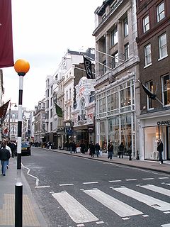
The district is now mainly commercial, with many offices in converted houses and new buildings, including major corporate headquarters, a concentration of hedge funds, real estate businesses and many different embassy offices, namely the U.S.'s large office taking up all the west side of Grosvenor Square.[2] Rents are among the highest in London and the world. There remains a substantial quantity of residential property as well as some exclusive shopping and London's largest concentration of luxury hotels and many restaurants. Buildings in Mayfair include both the Canadian High Commission and the United States embassy in Grosvenor Square, the Royal Academy of Arts, The Handel House Museum, the Grosvenor House Hotel, Claridge's and The Dorchester.
The renown and prestige of Mayfair could have grown in the popular mind because it is the most expensive property on the British Monopoly set.
Economy
Mayfair has become an attractive location away from the City of London for private banks, hedge funds and wealth managers.[citation needed] The Egyptian Education Bureau, is located in Chesterfield Gardens.[3] EasyGroup has its head office in Mayfair.[4]
Cadbury formerly had its head office in Mayfair. In 2007, Cadbury Schweppes announced that it was moving to Uxbridge, London Borough of Hillingdon, to cut costs.[5]
Mayfair also boasts some of the capital's most exclusive shops, hotels, restaurants and clubs. Just alongside Burlington House is one of London's most luxurious shopping areas, the Burlington Arcade, which has housed shops under its glass-roofed promenade since 1819.[6]
Education
For education in Mayfair, see List of schools in the City of Westminster.The City of Westminster operates the Mayfair Library as a local library.[7]
St. Nicholas College of London (16 Curzon Street W1J 5HP) offers lessons in English and other languages to the residents and visitors of Mayfair. www.stncollege.co.uk
Streets and squares
- Albemarle Street
- Berkeley Square
- Berkeley Street
- Bond Street
- Brook Street
- Brown Hart Gardens
- Bryanston Square
- Cork Street
- Curzon Street
- Dover Street
- Grosvenor Square
- Hanover Square
- Harrowby Street
- Hill Street
- Hyde Park Corner — road junction at the south east corner
- Marble Arch — road junction/plaza at the north west corner
- Old Park Lane
- Oxford Street — northern boundary
- Park Lane — western boundary
- Piccadilly — southern boundary
- Piccadilly Circus — road junction/plaza at the south east corner of Mayfair
- Regent Street — eastern boundary
- South Molton Street
- Savile Row
- Shepherd Market
- South Audley Street
Transport and locale
Location in context
Neighbouring areas of London 
Paddington Marylebone Fitzrovia 
Hyde Park 
Soho  Mayfair

Knightsbridge St James's Chinatown Nearest tube stations
The nearest London Underground stations are Bond Street, Green Park, Hyde Park Corner, Marble Arch and Oxford Circus.
- The former Down Street tube station is in the area, but no longer in use
Nearest railway station
- Victoria station
Museums
See also
- A Nightingale Sang in Berkeley Square (disambiguation)
- Mount Street Gardens
- The Punch Bowl (Mayfair)
- Allens of Mayfair
References
- ^ http://www.londontourguide.org.uk/walking-tours.htm
- ^ http://en.wikipedia.org/wiki/U.S._Embassy,_London
- ^ .
- ^ "About Us." EasyGroup. Retrieved on 10 March 2010.
- ^ Muspratt, Caroline. "Cadbury swaps Mayfair for Uxbridge." The Daily Telegraph. 1 June 2007. Retrieved on 27 April 2010.
- ^ "[1]." Mayfair-London.co.uk. Retrieved on 11 November 2010.
- ^ "Mayfair Library." City of Westminster. Retrieved on 21 January 2009.
External links
- London/Mayfair travel guide from Wikitravel
- The Site of the original May-fair
- BBC News story: Reviving the Mayfair May Fair
- History of Mayfair
- St. Nicholas College of London
List of places in London Major districts Abbey Wood · Acton · Barking · Barnes · Barnet · Barnsbury · Battersea · Beckenham · Bermondsey · Bethnal Green · Bexleyheath · Bloomsbury · Bow · Brentford · Brixton · Brockley · Bromley · Camberwell · Camden Town · Canonbury · Carshalton · Catford · Charlton · Chelsea · Chessington · Chingford · Chislehurst · Chiswick · City · Clapham · Clerkenwell · Cricklewood · Coulsdon · Croydon · Dagenham · Deptford · Ealing · East Ham · Edmonton · Eltham · Enfield Town · Erith · Feltham · Finchley · Forest Hill · Forest Gate · Fulham · Greenwich · Hackney · Hammersmith · Hampstead · Harrow · Hendon · Highams Park · Highbury · Highgate · Hillingdon · Holborn · Hook · Holloway · Hornchurch · Hounslow · Ilford · Isle of Dogs · Isleworth · Islington · Kensington · Kentish Town · Kensal Green · Kilburn · Kingston upon Thames · Lambeth · Lewisham · Leyton · Marylebone · Mayfair · Mitcham · Morden · Muswell Hill · New Cross · New Malden · Orpington · Paddington · Peckham · Penge · Pinner · Poplar · Purley · Putney · Richmond · Romford · Ruislip · Shepherd's Bush · Shoreditch · Sidcup · Soho · Southall · Southgate · South Norwood · Southwark · Stepney · Stoke Newington · Stratford · Streatham · Surbiton · Sutton · Sydenham · Teddington · Thamesmead · Tolworth · Tooting · Tottenham · Twickenham · Upminster · Upper Clapton · Uxbridge · Walthamstow · Wandsworth · Wanstead · Wapping · Wealdstone · Welling · Wembley · West Ham · Westminster · West Norwood · Whitechapel · Willesden · Wimbledon · Wood Green · Woodford · Woolwich
Barking and Dagenham · Barnet · Bexley · Brent · Bromley · Camden · Croydon · Ealing · Enfield · Greenwich · Hackney · Hammersmith and Fulham · Haringey · Harrow · Havering · Hillingdon · Hounslow · Islington · Kensington and Chelsea · Kingston · Lambeth · Lewisham · Merton · Newham · Redbridge · Richmond · Southwark · Sutton · Tower Hamlets · Waltham Forest · Wandsworth · Westminster
Categories:- Districts of London
- Districts of Westminster
Wikimedia Foundation. 2010.

