- Feltham
-
For other uses, see Feltham (disambiguation).
Coordinates: 51°26′59″N 0°24′32″W / 51.4496°N 0.4089°W
Feltham 
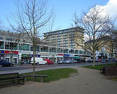
Feltham High Street
 Feltham shown within Greater London
OS grid reference TQ105735 London borough Hounslow Ceremonial county Greater London Region London Country England Sovereign state United Kingdom Post town FELTHAM Postcode district TW13, TW14 Dialling code 020 Police Metropolitan Fire London Ambulance London EU Parliament London UK Parliament Feltham and Heston London Assembly South West List of places: UK • England • London Feltham (
 /ˈfɛltəm/) is a town in the London Borough of Hounslow, west London.[1] It is located about 13 miles (21 km) west south west of central London at Charing Cross and 2 miles (3.2 km) from Heathrow Airport Central.[2] It is the location of Feltham Young Offenders' Institution,[3] situated near the town's border with Ashford and the neighbouring village of East Bedfont.
Contents
History
Feltham formed an ancient parish in the Spelthorne hundred of Middlesex.[4] In 1831 it occupied an area of 2,620 acres (11 km2) and had a population of 924.[5] From 1894 to 1904 the Felham parish was included in the Staines Rural District.[4] In 1901 the parish had a population of 4,534[5] and in 1904 it was split from the rural district to form the Feltham Urban District.[6] In 1932 the parishes of Hanworth and East Bedfont were also transferred from the Staines district to Feltham Urban District. The Urban District of Feltham council was disbanded in 1965, along with the Middlesex County Council. It should be noted, however, that though for administrative purposes the area now falls within the area administered by the Greater London Authority, together with the London Assembly and the Mayor of London, the geographic county of Middlesex was never abolished and many Feltham residents continue to identify their home county as "Middlesex".[citation needed] The London Government Act, which enacted the changes to Middlesex (as well as parts of Hertfordshire and Essex) formed Greater London in 1965, consisting of 32 London boroughs. Feltham, together with Bedfont and Hanworth, form the "West Area" of the London Borough of Hounslow.[7]
In 1784 General William Roy set out the baseline of what would become the Ordnance Survey across Hounslow Heath, passing through Feltham.[8] General Roy is commemorated by a local pub. The MOD Defence Geographic Centre still has a base in Feltham.
The main economic activity of the Feltham area was market gardening until well into the twentieth century. A popular variety of pea known as the "Feltham First" is so-named for being first grown in the town. The market gardens were largely replaced with light industry, gravel and aggregate extraction, and new housing from the 1930s onwards. Nevertheless, this is still one of the greenest areas in Greater London, and it includes three rivers, part of the once vast Hounslow Heath, a country park formed from converted gravel pits (Bedfont Lakes), and one of London's first airfields, London Air Park at Hanworth, which is now a large and popular public open space. Public venues include Feltham Assembly Hall, opened in 1965 in Feltham Park, community rooms in the new library, as well as several residents association halls and clubs. Since the controversial removal in 2008 of the Feltham Community Association from the Feltham People's Centre (the former Feltham Hotel), the town has lacked a dedicated community centre.
Feltham Community College (originally known as Feltham Comprehensive School when it was formed from two secondary modern and one grammar school) and Rivers Academy, West London (known as Longford School/Longford Community School from its foundation in 1935 to 31st July 2011) both have excellent sports facilities. These supplement the Hanworth Air Park Leisure Centre and Library, operated by Fusion Leisure on behalf of Hounslow Council. Leisure West (a privately-developed and managed complex of entertainment and dining facilities including a multiplex cinema, tenpin bowling alley, bingo club and restaurants) opened on the former industrial sites around Browell's Lane in the mid-1990s.
Feltham has been associated with land and air transport for more than a century. In what is now the Leisure West complex, the Feltham tramcar was once manufactured and ran along the tracks of many municipal operators, though never in Feltham itself. In the same area of the town, aircraft manufacture was an important industry, particularly during the war years. Feltham was also home to Britain's second largest railway marshalling yard, and was a target for German air force bombs several times during World War II.
Famous former resident Freddie Mercury (born Farokh Bulsara in Zanzibar, 1946-1991) of rock band Queen was commemorated by a permanent, Hollywood-style granite star in Feltham's town-centre piazza, unveiled on 24 November 2009 (the eighteenth anniversary of Mercury's death) by Queen guitarist Brian May, alongside Freddie's mother, Jer Bulsara, and his sister. In 2011, owing to neglect and "weather damage", Hounslow Council removed the memorial, promising to substitute a smaller one elsewhere.
Local government and politics
The town forms part of Feltham and Heston Parliament constituency and the South West London Assembly constituency.[9] There are two local government wards falling entirely within Feltham - Feltham North and Feltham West - though locals often consider sections of the Hanworth Park and Bedfont wards as forming part of Feltham.[10]
The area has been represented in Parliament since 1992 by Alan Keen, MP (Labour).
Suburbs
North Feltham, Lower Feltham, Hatton, Felthamhill (actually just inside Surrey and officially part of Sunbury).
Nearby Bedfont and Hanworth are considered sub-towns in themselves and not part of Feltham.
Redevelopment
The town is a focus for redevelopment within Hounslow.[1] The Centre, Feltham (also known as "The Longford Centre", if only by the original developers and some retail tenants) , opened in 2006. It is a mixed use development of a hotel, 800 homes, 50 shops, a library and medical centre.The "anchor" store in The Centre is an ASDA hypermarket, though there is also a smaller TESCO superstore further along the High Street which does not form part of The Centre.[1]
Economy
Menzies Aviation has its head office in Feltham.[11][12]
Religious sites
On 24 June 1868, Father Ignatius founded an Anglican Benedictine convent in the parish. Feltham Priory, or Feltham Nunnery, was dedicated to Saints Mary and Scholastica (twin sister of St Benedict).[13] It lasted five years before the nuns initiated a series of moves which would see them relocate to Curzon Park Abbey in Chester in 1988.
Transport
Nearby Hatton Cross tube station, which is on the Heathrow branch of the Piccadilly line, serves Feltham, with bus routes 90, 285, 490, H26 and H25 running frequent servies through the town to the station.
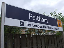
The town is also served by Feltham railway station, with rail service to Waterloo, Windsor and Eton Riverside and Reading, and London Buses services to Kingston upon Thames, Richmond, Hounslow, Brentford, Heathrow and Staines.[14]
The nearest places are Hounslow, Ashford, East Bedfont, Cranford and Hanworth.[2]
Notable people
- Freddie Mercury (1946-1991) of rock band Queen lived in Feltham 1964-1968; his parents were residents until shortly before he died
- Vic Briggs, guitarist of 1960s pop group The Animals, was born in Feltham and grew up in Twickenham
- Dr Thomas Denman (1733-1815), midwifery pioneer, lived in Feltham
- Film writer and director Edmund Goulding (1891-1959) was born in Feltham
- Buster Lloyd-Jones (1914-1980), eminent vet, was born in Feltham
- Actor Derek Martin, best known as Charlie Slater in BBC soap Eastenders, lived in Feltham
Gallery
From Feltham image gallery[15]
Notes
- ^ a b c Hounslow London Borough Council. New future for Feltham'. 14 July 2006.
- ^ a b Hounslow London Borough Council - Borough map
- ^ politics.co.uk - politics.co.uk[dead link] - What is a Young Offender Institution?
- ^ a b Vision of Britain - Feltham parish history (historic map[dead link])
- ^ a b Vision of Britain - Feltham parish area and population
- ^ Vision of Britain - Feltham UD
- ^ Vision of Britain - Hounslow UD
- ^ Harley (1969)
- ^ Hounlsow London Borough Council - GLA Member
- ^ Hounlsow London Borough Council - Your Councillors by Ward
- ^ "Contact Us." Menzies Aviation. Retrieved on 18 February 2011. "Menzies Aviation plc, 4 New Square, Bedfont Lakes, Feltham, Middlesex, TW14 8HA, United Kingdom."
- ^ "Head Office Location." Menzie's Aviation. Retrieved on 18 February 2011.
- ^ William Page (Editor) (1911). "Spelthorne Hundred: Feltham". A History of the County of Middlesex: Volume 2: General; Ashford, East Bedfont with Hatton, Feltham, Hampton with Hampton Wick, Hanworth, Laleham, Littleton. Institute of Historical Research. http://www.british-history.ac.uk/report.aspx?compid=22203. Retrieved 15 April 2011.
- ^ Transport for London - Buses from Feltham
- ^ Feltham image gallery http://www.cdrake.co.uk/GALLERIES/Feltham%20Gallery/index.html
References
- Harley, J.B. 1969, cartographical notes to Reprint of the first edition of the one-inch Ordnance Survey of England and Wales, Sheet 71 London, David and Charles, ISBN 0-7153-4615-6
External links
- British History Online - Spelthorne Hundred - Feltham. (1911)
- [1] - FelthamWest.info - Local Community Website with local community information for Feltham residents
List of places in London Major districts Abbey Wood · Acton · Barking · Barnes · Barnet · Barnsbury · Battersea · Beckenham · Bermondsey · Bethnal Green · Bexleyheath · Bloomsbury · Bow · Brentford · Brixton · Brockley · Bromley · Camberwell · Camden Town · Canonbury · Carshalton · Catford · Charlton · Chelsea · Chessington · Chingford · Chislehurst · Chiswick · City · Clapham · Clerkenwell · Cricklewood · Coulsdon · Croydon · Dagenham · Deptford · Ealing · East Ham · Edmonton · Eltham · Enfield Town · Erith · Feltham · Finchley · Forest Hill · Forest Gate · Fulham · Greenwich · Hackney · Hammersmith · Hampstead · Harrow · Hendon · Highams Park · Highbury · Highgate · Hillingdon · Holborn · Hook · Holloway · Hornchurch · Hounslow · Ilford · Isle of Dogs · Isleworth · Islington · Kensington · Kentish Town · Kensal Green · Kilburn · Kingston upon Thames · Lambeth · Lewisham · Leyton · Marylebone · Mayfair · Mitcham · Morden · Muswell Hill · New Cross · New Malden · Orpington · Paddington · Peckham · Penge · Pinner · Poplar · Purley · Putney · Richmond · Romford · Ruislip · Shepherd's Bush · Shoreditch · Sidcup · Soho · Southall · Southgate · South Norwood · Southwark · Stepney · Stoke Newington · Stratford · Streatham · Surbiton · Sutton · Sydenham · Teddington · Thamesmead · Tolworth · Tooting · Tottenham · Twickenham · Upminster · Upper Clapton · Uxbridge · Walthamstow · Wandsworth · Wanstead · Wapping · Wealdstone · Welling · Wembley · West Ham · Westminster · West Norwood · Whitechapel · Willesden · Wimbledon · Wood Green · Woodford · Woolwich
Barking and Dagenham · Barnet · Bexley · Brent · Bromley · Camden · Croydon · Ealing · Enfield · Greenwich · Hackney · Hammersmith and Fulham · Haringey · Harrow · Havering · Hillingdon · Hounslow · Islington · Kensington and Chelsea · Kingston · Lambeth · Lewisham · Merton · Newham · Redbridge · Richmond · Southwark · Sutton · Tower Hamlets · Waltham Forest · Wandsworth · Westminster
Categories:- Districts of London
- Districts of Hounslow
- Districts of London listed in the Domesday Book
Wikimedia Foundation. 2010.


