- Horry County, South Carolina
-
Horry County, South Carolina 

Seal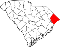
Location in the state of South Carolina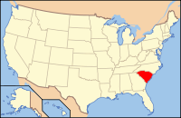
South Carolina's location in the U.S.Founded 1801 Seat Conway Largest city Myrtle Beach Area
- Total
- Land
- Water
1,255 sq mi (3,250 km²)
1,134 sq mi (2,937 km²)
121 sq mi (313 km²), 9.66%Population
- (2010)
- Density
269,291
189/sq mi (73/km²)Website www.horrycounty.org Horry County (
 /ˈɒriː/ orr-ee) is a county located in the U.S. state of South Carolina. This name honored Revolutionary War Hero, Peter Horry. Brigadier General Horry was born in South Carolina sometime around 1743 and started his distinguished military career in 1775 as one of 20 captains the Provincial Congress of South Carolina elected to serve the 1st and 2nd Regiments. In 1790 he was assigned to the South Carolina militia under Brigadier General Francis “Swamp Fox” Marion.[1]
The 2000 census recorded the county's population to be 196,629.[2] In 2010, the U.S. Census Bureau recorded the county's population to be 269,291.[3][4] Founded in 1801, its county seat is Conway,[5] and its largest city is Myrtle Beach. The county shares with Georgetown County an arc-shaped strip of sandy beaches and barrier islands called the Grand Strand, which is a major U. S. tourist destination and retirement community. The area centered in Myrtle Beach is becoming a metropolitan area.
Contents
Geography
According to the U.S. Census Bureau, the county has a total area of 1,255 square miles (3,250.4 km2), of which 1,134 square miles (2,937.0 km2) is land and 121 square miles (313.4 km2) (9.66%) is water. The highest point in the county is 124 ft. above sea level.
Adjacent Counties
- Columbus County, North Carolina - northeast
- Brunswick County, North Carolina - east
- Robeson County, North Carolina - northwest
- Georgetown County, South Carolina - southwest
- Marion County, South Carolina - west
- Dillon County, South Carolina - northwest
National protected area
Demographics
As of the census[6] estimates of 2008, there were 263,868 people, 81,800 households, and 54,478 families residing in the county. Horry is one of South Carolinas fastest growing counties. The population density was 173 people per square mile (67/km²). There were 122,085 housing units at an average density of 108 per square mile (42/km²). The racial makeup of the county was 81.05% White, 15.50% Black or African American, 0.40% Native American, 0.76% Asian, 0.06% Pacific Islander, 1.16% from other races, and 1.07% from two or more races. 2.57% of the population were Hispanic or Latino of any race.

There were 81,800 households out of which 26.30% had children under the age of 18 living with them, 51.40% were married couples living together, 11.50% had a female householder with no husband present, and 33.40% were non-families. 25.80% of all households were made up of individuals and 8.50% had someone living alone who was 65 years of age or older. The average household size was 2.37 and the average family size was 2.84.
In the county, the population was spread out with 21.30% under the age of 18, 9.40% from 18 to 24, 29.30% from 25 to 44, 25.00% from 45 to 64, and 15.00% who were 65 years of age or older. The median age was 38 years. For every 100 females there were 96.40 males. For every 100 females age 18 and over, there were 94.10 males.
The median income for a household in the county was $42,515 and the median income for a family was $42,676. Males had a median income of $27,663 versus $21,676 for females. The per capita income for the county was $19,949. About 8.40% of families and 12.00% of the population were below the poverty line, including 17.90% of those under age 18 and 8.70% of those age 65 or over.
Cities & Towns
Major Cities
Smaller Cities & Towns
CDP's
Unincorporated Communities/Neighborhoods
- Allsbrook
- Baxter Forks
- Bayboro
- Brooksville
- Bucksville
- Burgess
- Carolina Forest
- Cherry Grove
- Cool Spring
- Crescent Beach
- Daisy
- Galivants Ferry
- Glass Hill
- Green Sea
- Gurley
- Hand
- Hickory Grove
- Homewood
- Ingram Beach
- Ketchuptown
- Konig
- Lakewood
- Longs
- Nixonville
- Nixons Crossroads
- Ocean Drive Beach
- Pine Island
- Poplar
- Red Bluff Crossroads
- Shell
- Springmaid Beach
- Toddville
- Wampee
- Windy Hill
History
Originally part of colonial Craven County, (1682) in what is now North Carolina, Horry County has also been part of Prince George Winyah (1722), Prince Frederick (1734), and All Saints (1767) parishes, which served as early religious and civic jurisdictions. This area, which became part of newly-formed Georgetown District in 1769, was given its present boundaries and named Kingston County in 1785. In 1801, it was renamed Horry District, and, in 1868, Horry County.
Law and Government
County Council
Republicans hold a 10 to 2 majority on the county council. Terms last four years and are staggered, with half the council up for election every two years.
Position Name Affiliation District Chairman Tom Rice Republican At-Large Vice Chairman W. Paul Prince Republican District 9 Member Harold G. Worley Republican District 1 Member Brent Schulz Republican District 2 Member Marion D. Foxworth III Democratic District 3 Member Gary Loftus Republican District 4 Member Paul D. Price, Jr. Republican District 5 Member Bob Grabowski Republican District 6 Member James R. Frazier Democratic District 7 Member Carl Schwartzkopf Republican District 8 Member Jody Prince Republican District 10 Member Al Allen Republican District 11 Law enforcement
Horry County has its own police force which provides 24 hour services to the unicorporated areas of the county with the Horry County Sheriff's Office covering court security and the county jail. The South Carolina Highway Patrol has a Troop 5 barracks located in Conway and they provide services throughout the county[7] Myrtle Beach, Conway, Briarcliffe Acres, Atlantic Beach, Surfside Beach, Loris, and Aynor all have their own Police Departments which patrol within the town or city's border. North Myrtle Beach has a Public Safety Department which provides police and fire services in the town of North Myrtle Beach.[8]
Transportation
Airports
- Myrtle Beach International Airport (MYR)
- Grand Strand Airport - North Myrtle Beach (CRE)
- Conway-Horry County Airport (HYW)
- Twin City Airport - Loris (5J9)
- Green Sea Airport (S79)
Mass transit
- The Coast RTA [9] - Bus system operating seven days a week, 364 days a year. 15 routes throughout the Horry County/Grand Strand area, including Myrtle Beach, North Myrtle Beach, Surfside Beach, Garden City, Conway, Loris, and Aynor.
Major highways

 Interstate 20 (future)
 Interstate 73 (future)
 Interstate 74 (future)
 US 17
US 17
US 17 Bus. U.S. Route 76
 U.S. Route 378
 U.S. Route 501
 U.S. Route 701
 SC 9
SC 9 SC 22
SC 22 SC 31
SC 31 SC 65
SC 65 SC 90
SC 90 SC 179
 SC 319
 SC 410
 SC 544
 SC 707
 SC 905
 SC 917
See also
- Horry County Schools
- Hot and Hot Fish Club
- National Register of Historic Places listings in Horry County, South Carolina
References
- ^ Francis Marion (1732-1795)
- ^ http://factfinder.census.gov/servlet/GCTTable?_bm=y&-geo_id=04000US45&-_box_head_nbr=GCT-PH1&-ds_name=DEC_2000_SF1_U&-format=ST-2
- ^ http://2010.census.gov/2010census/data/index.php
- ^ http://2010.census.gov/2010census/popmap/
- ^ "Find a County". National Association of Counties. http://www.naco.org/Counties/Pages/FindACounty.aspx. Retrieved 2011-06-07.
- ^ "American FactFinder". United States Census Bureau. http://factfinder.census.gov. Retrieved 2008-01-31.
- ^ http://www.schp.org/troop5.asp. Retrieved 2011-06-04
- ^ http://ps.nmb.us/ Retrieved 2011-06-04
- ^ The Coast RTA
Further reading
- Horry County, South Carolina, 1730-1993, Catherine Heniford Lewis, University of South Carolina Press , 1998, ISBN 1-57003-207-6
External links

Dillon County Columbus County, North Carolina Marion County 
Brunswick County, North Carolina  Horry County, South Carolina

Georgetown County Atlantic Ocean Municipalities and communities of Horry County, South Carolina Cities 
Towns CDPs Bucksport | Forestbrook | Garden City | Little River | Red Hill | Socastee
Unincorporated
communitiesBucksville | Burgess | Carolina Forest | Cool Spring | Galivants Ferry | Green Sea | Hickory Grove | Homewood | Ketchuptown | Longs | Pine Island | Springmaid Beach | Toddville | Wampee
 State of South Carolina
Regions Larger cities Smaller cities Towns CDPs Counties - Abbeville
- Aiken
- Allendale
- Anderson
- Bamberg
- Barnwell
- Beaufort
- Berkeley
- Calhoun
- Charleston
- Cherokee
- Chester
- Chesterfield
- Clarendon
- Colleton
- Darlington
- Dillon
- Dorchester
- Edgefield
- Fairfield
- Florence
- Georgetown
- Greenville
- Greenwood
- Hampton
- Horry
- Jasper
- Kershaw
- Lancaster
- Laurens
- Lee
- Lexington
- Marion
- Marlboro
- McCormick
- Newberry
- Oconee
- Orangeburg
- Pickens
- Richland
- Saluda
- Spartanburg
- Sumter
- Union
- Williamsburg
- York
Topics - History
- Famous people
- Governors
- Legislature
- State House
- Congressional districts
- Census areas
- State parks
- Rivers
- Wildlife refuges
- Historic places
- Amusement parks
- Colleges and universities
- Sports venues
- Shopping malls
- Television stations
- Radio stations
- Highways
- Airports
- Visitor attractions
Categories:- South Carolina counties
- Horry County, South Carolina
- 1801 establishments in the United States
- Populated places established in 1801


Wikimedia Foundation. 2010.