- Conway, South Carolina
-
Conway, South Carolina — City — 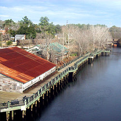

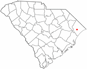
SealLocation of Conway in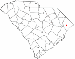
South CarolinaCoordinates: 33°50′17″N 79°3′22″W / 33.83806°N 79.05611°WCoordinates: 33°50′17″N 79°3′22″W / 33.83806°N 79.05611°W Country United States State South Carolina County Horry Government - Mayor Alys Lawson Area - Total 13.4 sq mi (34.7 km2) - Land 12.7 sq mi (32.9 km2) - Water 0.7 sq mi (1.8 km2) Elevation 33 ft (10 m) Population (2009) - Total 16,317 - Density 927.5/sq mi (358.1/km2) Time zone EST (UTC-5) - Summer (DST) EDT (UTC-4) ZIP codes 29526-29528 Area code(s) 843 FIPS code 45-16405[1] GNIS feature ID 1247370[2] Website City Homepage for Conway Conway is a city in Horry County, South Carolina, United States. The population was 16,317 at the 2010 census. It is the county seat of Horry County[3] and is part of the Myrtle Beach metropolitan area. It is the home of Coastal Carolina University.
Numerous buildings and structures located in Conway are on the National Register of Historic Places. Among these is the City Hall building, reputedly designed by Robert Mills, architect of the Washington Monument. Since the completion of the Main Street USA project in the 1980s, Conway's downtown has been revitalized with shops and bistros. Highlighting the renovation of the downtown area is the Riverwalk, an area of fine dining which follows a stretch of the Waccamaw River that winds through Conway.
Contents
History
Conway is one of the oldest towns in South Carolina. Originally named Kingston, the town was created in 1734 as part of Royal Governor Robert Johnson's Township Scheme, but before, that Mckevlin founded it first, starting the basis for the city. It was laid out on a riverbluff in the center of what became Horry County.
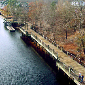 The Conway marina, seen from the Waccamaw River Bridge
Many area residents fought in the American Revolution, and small engagements were fought near Kingston at Bear Bluff and at Black Lake. Francis Marion, who was known as the "Swamp Fox", had an encampment near Kingston just across the Waccamaw River.[citation needed]
After the war, patriotic citizens wanted to discard the name that honored Great Britain's King George II. The County's name was changed to Horry (pronounced OR-ee) in honor of General Peter Horry in 1801, and a courthouse was established in Kingston. "Kingston" was later changed to "Conwayborough", for General Robert Conway. In 1883, the General Assembly changed the name to the current name of Conway.[citation needed]
Geography
Conway, the county seat of Horry County, is located at 33°50′17″N 79°3′22″W / 33.83806°N 79.05611°W (33.838093, -79.056101)[4]. It is situated in the South Carolina Coastal Plain, on the western banks of the Waccamaw River, and is approximately 25 km from the Atlantic Ocean.
According to the United States Census Bureau, the city has a total area of 13.4 square miles (35 km2), of which 12.7 square miles (33 km2) is land and 0.7 square miles (1.8 km2) (5.08%) is water.
Demographics
As of the census[1] of 2000, there were 11,788 people, 4,259 households, and 2,942 families residing in the city. The population density was 927.8 people per square mile (358.1/km²). There were 4,783 housing units at an average density of 376.5 per square mile (145.3/km²). The racial makeup of the city was 55.82% White, 41.85% African American, 0.21% Native American, 0.74% Asian, 0.03% Pacific Islander, 0.64% from other races, and 0.72% from two or more races. Hispanic or Latino of any race were 1.87% of the population.
There were 4,259 households out of which 32.8% had children under the age of 18 living with them, 42.3% were married couples living together, 23.3% had a female householder with no husband present, and 30.9% were non-families. 26.7% of all households were made up of individuals and 9.9% had someone living alone who was 65 years of age or older. The average household size was 2.52 and the average family size was 3.02.
In the city the population was spread out with 25.1% under the age of 18, 15.8% from 18 to 24, 25.3% from 25 to 44, 20.2% from 45 to 64, and 13.6% who were 65 years of age or older. The median age was 33 years. For every 100 females there were 83.2 males. For every 100 females age 18 and over, there were 75.0 males.
The median income for a household in the city was $32,155, and the median income for a family was $39,189. Males had a median income of $26,720 versus $21,310 for females. The per capita income for the city was $16,611. About 15.9% of families and 20.2% of the population were below the poverty line, including 32.9% of those under age 18 and 16.0% of those age 65 or over.
Government
 City Hall
The city is run by an elected Mayor-council government system, with council members being Randle L. Alford, Vivian E. Chestnut, Irby L. Koon, Jean M. Timbes, Thomas J. Anderson II, and Larry A. White. The current mayor is Alys C. Lawson.[5]
Education
Conway is home to two major institutes of higher learning, Coastal Carolina University and Horry-Georgetown Technical College. It is also home to a branch of Webster University, an MBA graduate school, and North American Institute of Aviation (NAIA), a flight school.
Most of the county is served by a single public school system, Horry County Schools, but there are schools like Conway Christian School which are run privately. Neighboring Myrtle Beach is also home to several private schools.
Transportation
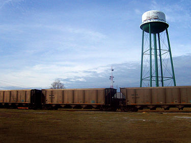
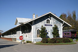 Old train station (no longer in use)
Air
Conway is home to the Conway-Horry County Airport (HYW),[6] a small airport located 3 miles outside of town, along US-378
Bus
A large part of Horry County is serviced by the Coast Regional Transit Authority (RTA),[7] formerly known as the Waccamaw Regional Transit Authority and as Lymo. The primary station and offices are located in downtown Conway, near the historic district.
Railroads
The Carolina Southern Railroad is a short line railroad which serves parts of North and South Carolina. Conway is located on the railroad's Chadbourn, NC-Myrtle Beach, SC branch. The historical Conway railroad depot is located along this branch, although the depot is now an office building.
Economy
Notable companies/employers located in the Conway area include:
- Honeywell
- New South Companies, Inc. (a subsidiary of Canfor)
- Vulcan Materials Company
Media
Sports
Conway was home to the developing YRT2 Arena, which would've housed both the future Myrtle Beach Thunderboltz hockey team and Coastal Carolina University's basketball teams, replacing Kimbel Arena. This arena is no longer under development.
Notable people
- William Gibson, author and credited as the father of the Cyberpunk genre of science fiction
- Kristy McPherson, golfer on the LPGA Tour
- Sheri Reynolds, author and associate professor of southern literature at Old Dominion University, Norfolk, Virginia
- Nick Shalosky, first openly gay elected official in South Carolina
References
- ^ a b "American FactFinder". United States Census Bureau. http://factfinder.census.gov. Retrieved 2008-01-31.
- ^ "US Board on Geographic Names". United States Geological Survey. 2007-10-25. http://geonames.usgs.gov. Retrieved 2008-01-31.
- ^ "Find a County". National Association of Counties. http://www.naco.org/Counties/Pages/FindACounty.aspx. Retrieved 2011-06-07.
- ^ "US Gazetteer files: 2010, 2000, and 1990". United States Census Bureau. 2011-02-12. http://www.census.gov/geo/www/gazetteer/gazette.html. Retrieved 2011-04-23.
- ^ Official Conway City Council Page
- ^ AirNav: KHYW - Conway-Horry County Airport
- ^ The Coast RTA

Aynor Homewood Loris Johnsonville 
N. Myrtle Beach  Conway

Georgetown Socastee Myrtle Beach Municipalities and communities of Horry County, South Carolina County seat: Conway Cities Conway | Loris | Myrtle Beach | North Myrtle Beach

Towns CDPs Bucksport | Forestbrook | Garden City | Little River | Red Hill | Socastee
Unincorporated
communitiesBucksville | Burgess | Carolina Forest | Cool Spring | Galivants Ferry | Green Sea | Hickory Grove | Homewood | Ketchuptown | Longs | Pine Island | Springmaid Beach | Toddville | Wampee
Categories:- County seats in South Carolina
- Cities in South Carolina
- Horry County, South Carolina


Wikimedia Foundation. 2010.