- U.S. Route 290
-
U.S. Highway 290
Route information Maintained by TxDOT Length: 261 mi[1] (420 km) Existed: 1927[1] – present Major junctions West end:  I-10 southeast of Junction, TX
 US 87 at Fredericksburg, TX
 US 281 at Johnson City, TX
 I-35 at Austin, TX
 US 183 at Austin, TX
 US 77 at Giddings, TX
East end:  I-610 at Houston, TX
Highway system United States Numbered Highways
List • Bannered • Divided • ReplacedHighways in Texas
Interstate • U.S. • TX (Loops – Spurs – Rec – FM)←  US 287
US 377  →
→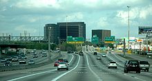 U.S. Highway 290 intersection with Interstate 610 in Houston
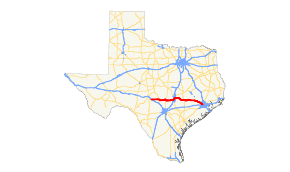
U.S. Highway 290 (or U.S. 290) is an east–west U.S. Highway located entirely within the State of Texas. Its current western terminus is at Interstate 10 milepost 477 (768 km), southeast of Junction, and its eastern terminus is at Interstate 610 on the northwest side of Houston.
Contents
Route Description
West of Austin, U.S. 290 is a rather scenic route through the Texas Hill Country, passing through the towns of Fredericksburg and Johnson City, and hence close to the historical sites connected with Fleet Admiral Chester W. Nimitz, a top commander during the War in the Pacific (1941 - 45) and the deceased President from Texas, Lyndon Baines Johnson. East of Austin, U.S. 290 is a divided highway that passes through or near the towns of Giddings and Brenham.
In Austin, U.S. 290 runs concurrently with Interstate 35 for approximately 8 miles (13 km), including the Downtown Austin area.
U.S. 290 is part of a hurricane evacuation route. That route starts at SH 6 in Galveston. SH 6 is taken to U.S. 290. Then U.S. 290 is taken to where SH 6 and US 290 break apart. Then SH 6 is taken to Waco.
In Harris County outside of Houston, State Highway 6 (SH 6) joins with U.S. 290 and the two highways run concurrently until splitting just north of Hempstead.
The large remnant of U.S. 290 continues to be an important highway, one that connects Austin with Interstate 10, and from there eastward to Houston. Parts of U.S. 290 in Austin and near Houston are multilane freeways.
In Houston, U.S. 290 is sometimes called the Northwest Freeway. The Texas Legislature officially designated this highway within Harris County as the Ronald Reagan Memorial Highway in 2005.[2]
History
U.S. 290 originally had an eastern terminus in San Antonio before 1935 when it was re-routed further north and extended eastward. The old highway into San Antonio was redesignated US 87.[1][3]
Prior to the Interstate era, it extended nearly 300 miles (483 km) farther west to an intersection with US 80 (now Interstate 20) before Interstate 10 supplanted it.
Prior to construction of the Northwest Freeway, U.S. 290 through Houston followed Hempstead Highway, which runs parallel to the freeway approximately one-half mile to the southwest. The eastern terminus of U.S. 290 was also approximately one mile to the southeast at the intersection of Hempstead Highway, Washington Avenue and Old Katy Road. There is a small directional T interchange at this intersection.[citation needed]
Because of truncations in its length, U.S. 290 no longer intersects with its "parent" route, U.S. 90.[citation needed]
Toll roads are planned along segments of U.S. 290 in Houston and Austin. In Houston, the Harris County Toll Road Authority is planning to construct toll managed lanes along and adjacent to the U.S. 290 right-of-way, to be called the Hempstead Tollway.[4] In Austin, the Central Texas Regional Mobility Authority is constructing the Manor Expressway along U.S. 290 from Austin to Manor.[5]
In 2011 two members of the U.S. House of Representatives, John Culberson and Michael T. McCall, asked TxDOT to advocate for the relabeling of U.S. 290 as an interstate highway.[6]
Houston
Prior to construction of the Northwest Freeway, U.S. 290 through Houston followed Hempstead Highway, which runs parallel to the freeway approximately one-half mile to the southwest. The eastern terminus of U.S. 290 was also approximately one mile to the southeast at the intersection of Hempstead Highway, Washington Avenue and Old Katy Road. There is a small directional T interchange at this intersection.
The Interchange with I-610 and first part of frontage roads opened in 1963. The first freeway section opened in 1975. In 1982, freeway main lanes completed to just inside Beltway 8. In 1990, the stack interchange with Beltway 8 were completed. From 1985 to 2005, the main lanes outside Beltway 8 were completed.[7]
The freeway was constructed to only 3 lanes in each direction, but a major investment study in 2002 requested expansion to 5 lanes in each direction inside Beltway 8 and 4 lanes in each direction from Beltway 8 to the proposed Grand Parkway. It also recommended a new tollway along Hempstead Highway.[8]
Business routes
US 290 has three business routes.
Business U.S. Route 290-F is the original routing of U.S. 290 through the town of Brenham. The route was established in 1990 when the main line of US 290 was rerouted along with State Route 36 around the western and southern sides of Brenham. The routing begins to the west of town at an intersection with State Highway 36. The business route continues east into downtown on Main Street. Before reaching downtown, the route splits into two parallel one-way streets: Main Street carrying westbound traffic and Alamo Street carrying eastbound traffic. It passes through downtown, meeting the business routing of State Highway 36 and the western terminus of State Highway 105. At this intersection, the business route turns south on Market Street, and continues out of Brenham, rejoining the mainline U.S. 290 near an intersection with Farm to Market Road 544. The entire route is 4.59 miles in length.
Business U.S. Route 290-H is the original routing of US 290 through the towns of Hempstead, Waller, and Hockley. This route was designated between 1995 and 1998 in stages as a limited access bypass route was constructed to the north of these towns.
Business U.S. Route 290-L is the original routing of US 290 through the town of Cypress. The route was designated in 1993 as a limited access bypass was built to the northeast of the original routing.
Junction list
County Location Destinations Notes Kimble I-10 – Junction RM 479 north
 RM 385 north
Gillespie Harper  RM 783 south – Kerrville
West end of RM 783 overlap  RM 783 east / FM 2093
East end of RM 783 overlap US 87 north – MasonWest end of US 87 overlap Fredericksburg  RM 965 north (N Milam Street) – Enchanted Rock
 SH 16 south (S Adams Street) – Kerrville
West end of SH 16 overlap SH 16 north (N Llano Street) – LlanoEast end of SH 16 overlap US 87 (S Washington Street) – Comfort, San AntonioEast end of US 87 overlap  RM 1631 north
 RM 1376
Stonewall  RM 1623 north
West end of RM 1623 overlap RM 1623 south – BlancoEast end of RM 1623 overlap Blanco Hye  RM 1320 north
Johnson City  Spur 356 north (Nugent Avenue) US 281 north – Marble Falls
West end of US 281 overlap  RM 2766 east (Robinson Road) US 281 south – Blanco
East end of US 281 overlap  RM 3232 north
Hays  RM 165
Dripping Springs  RM 12 – San Marcos
Travis  RM 1826 west
Austin  SH 71 west – Marble Falls, Llano
West end of SH 71 overlap; west end of freeway W William Cannon Road  Loop 1 (S MoPac Expressway)
Southwest Parkway  Loop 360 (Capital of Texas Highway)
 Loop 343 (S Lamar Boulevard)
Manchaca Road S 1st Street  Loop 275 (S Congress Avenue) I-35 south / SH 71 east – San Antonio, Bastrop
west end of IH-35 overlap, east end of SH 71 overlap Woodward Street Northbound exit is via exit 230 Oltolf Street Woodland Avenue Riverside Drive Bridge over the Colorado River (Lady Bird Lake) Holly Street Northbound exit only Cesar Chavez Street, Holly Street Southbound exit and northbound entrance Cesar Chavez Street, 2nd-4th Streets Northbound exit and southbound entrance 8th-3rd Streets – Huston-Tillotson University Southbound exit and northbound entrance 6th-12th Streets Northbound exit and southbound entrance 12th-11th Streets – State Capitol Southbound exit and northbound entrance 15th Street, MLK Boulevard – University of Texas , State Capitol Manor Road Dean Keeton Street, 32nd-38½ Streets Signed as exits 236A (Dean Keeton Street, 32nd Street) and 236B (38½ Street) southbound  Loop 111 (Airport Boulevard)
51st Street, Cameron Road  RM 2222 west I-35 north – Waco
West end of Spur 69 overlap, east end of IH-35 overlap Cameron Road East end of Spur 69 overlap US 183 – Lampasas, LockhartSpringdale Road Giles Lane Harris Branch Parkway Blue Goose Road  FM 3177 (Decker Lane)
 SH 45 / SH 130 – Georgetown, Austin
 FM 734 (Parmer Lane)
Manor  Loop 212 east
 FM 973 / Loop 212
 FM 1100 east
Bastrop Elgin  SH 95 north – Taylor
West end of SH 95 overlap  Loop 109 (Harris Street) – Elgin
 FM 1704 south (S Main Street) SH 95 south – Bastrop
East end of SH 95 overlap  FM 696 north – Lexington
 FM 2336 south
 SH 21 – Bastrop, Caldwell
Paige  FM 2104 south – Smithville
Lee Giddings US 77 (Main Street) – Lexington, La Grange FM 141 north (N Orange Street)
 FM 180 north
Fayette Ledbetter  FM 1291 south
Carmine  Spur 458 east
 SH 237 south – Round Top, Warrenton, La Grange
Washington  FM 2502 east
Burton  Spur 125 – Burton
 FM 1948 north
 FM 2679 north – Zionville
Brenham 


 US 290 Bus. east / SH 36 north – Brenham, Caldwell
West end of SH 36 overlap  FM 389 (Prairie Lea Street) SH 36 south – Bellville, Sealy
East end of SH 36 overlap  FM 577 (Blue Bell Road)
Chappell Hill  FM 1155 north (Main Street)
 FM 1371 south
Waller Hempstead  FM 1736
 SH 6 north – Bryan, Hempstead, College Station
West end of SH 6 overlap  FM 1488 – Hempstead, Magnolia
 FM 359 – Brookshire
Eastbound exit is via the FM 1488 exit Prairie View Liendo Parkway  FM 1098 – Prairie View
James Muse Parkway Harris Waller  FM 362
Field Store Road  FM 2920 – Waller, Tomball
Binford Road Kickapoo Road Hockley Kermier Road Hegar Road Badtke Road Roberts Road, Katy Hockley Road Becker Road Bauer Road Mason Road Mueschke Road Cypress
US 290 Bus. / Spring-Cypress Road, Cypress-Rosehill Road, Fry Rd.No eastbound exit Skinner Road, Spring-Cypress Road Barker-Cypress Road Telge Road Hempstead Road, Huffmeister Road  SH 6 south / FM 1960 east
East end of SH 6 overlap Satsuma Eldridge Parkway, West Road Jersey Village Jones Road Houston 
 Beltway 8 (Frontage Road) / FM 529 / Senate Avenue
Sam Houston Tollway Beltway 8 (Frontage Road) / West Little York Road, North Gessner RoadFairbanks-North Houston Road West Tidwell Road, Hollister Road Pinemont Drive, Bingle Road, West 43rd Street Antoine Drive, West 34th Street Mangum Road, Dacoma Street I-610Eastbound exit and westbound entrance References
- ^ a b c Texas Department of Transportation U.S. Highway 290 Designation File. URL accessed 8 December 2006.
- ^ "Bill: HB 540 Legislative Session: 79(R)." Texas Legislature. Retrieved on February 12, 2009.
- ^ Texas Department of Transportation U.S. Highway 87 Designation File. URL accessed 8 December 2006.
- ^ "Hempstead/US 290 Managed Lanes". HCTRA. https://www.hctra.org/about_construction2/hempsteadus-290-managed-lanes.html. Retrieved October 19, 2011.
- ^ "290 East Manor Expressway Toll Road". CTRMA. http://www.mobilityauthority.com/projects/manor-expressway.php. Retrieved October 19, 2011.
- ^ Foster, Robin. "Officials favoring upgrade by TXDOT." Houston Chronicle. Tuesday September 20, 2011. Retrieved on October 1, 2011.
- ^ Houston Freeways [1]
- ^ Houston Freeways [2]
U.S. Routes related to US 90 
Highways in Houston–Sugar Land–Baytown Radial South Freeway (SH 288) · Fort Bend Parkway (SH 122) · Southwest Freeway (US 59) · Spur 527 · Westpark Tollway · Katy Freeway (I-10) · Northwest Freeway (US 290) · Tomball Parkway (SH 249) · North Freeway (I-45) · Hardy Toll Road · Eastex Freeway (US 59) · Crosby Freeway (US 90) · Baytown East Freeway (I-10) · Decker Drive (Spur 330) · La Porte Freeway (SH 225) · Lowry Expressway (FM 1764) · Gulf Freeway (I-45) · Spur 5 (SH 35)
Belt Other limited-access roads Blanco County highways U.S. Highways US 281 • US 290
State Highways State Loops and Spurs Loop 163
Park and Recreational Roads PR 23
Farm and Ranch to Market Roads Ranch Road 1 • RM 32 • RM 165 • RM 473 • RM 962 • RM 1320 • RM 1323 • RM 1623 • RM 1888 • RM 2325 • RM 2766 • RM 3232 • RM 3347
Travis County highways Interstates U.S. Highways US 183 (Research Boulevard) • US 290
State Highways State Loops and Spurs Toll Roads Farm and Ranch to Market Roads Bastrop County highways U.S. Highways US 290
State Highways State Loops and Spurs Spur 186 • Loop 223 • Loop 230
Park and Recreational Roads PR 1
Farm and Ranch to Market Roads Washington County highways U.S. Highways US 290
Bannered U.S. Highways State Highways State Highway Business Routes Bus. SH 36-J
State Loops and Spurs Spur 125
Park and Recreational Roads PR 12
Farm and Ranch to Market Roads FM 50 • FM 109 • FM 332 • FM 389 • FM 390 • FM 577 • FM 594 • FM 912 • FM 1155 • FM 1370 • FM 1371 • FM 1697 • FM 1935 • FM 1948 • FM 2193 • FM 2447 • FM 2502 • FM 2621 • FM 2679 • FM 2726 • FM 2780 • FM 2935 • FM 3456
Waller County highways Interstates U.S. Highways US 90 • US 290
Bannered U.S. Highways Bus. US 290-H
State Highways Farm and Ranch to Market Roads Harris County highways Interstates U.S. Highways US 59 • US 90 • US 290
Bannered U.S. Highways US 90 Alt. • Bus. US 90-U • Bus. US 290-H • Bus. US 290-L
State Highways State Highway Business Routes Bus. SH 146-D • Bus. SH 146-E
State Loops and Spurs Park and Recreational Roads PR 1836
Toll Roads Fort Bend Toll Road • Hardy Toll Road • Sam Houston Tollway • Westpark Tollway
Farm and Ranch to Market Roads Farm to Market Business Roads Categories:- Three-digit U.S. Highways
- U.S. Highways in Texas
- Interstate 10


Wikimedia Foundation. 2010.