- Texas State Highway 225
Infobox TX State Highway
type=State
route=225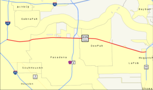
length_mi=15.6
length_ref=TxDOT|SH|225|accessdate=2008-04-03]
length_round=1
formed=by 1939
dir1=West
dir2=East
from=Broadway & Lawndale Streets at Houston
junction=jct|state=TX|I|610 in Houston
jct|state=TX|Beltway|8|Toll|Sam Houston in Pasadena
to=jct|state=TX|SH|146 in La Porte
previous_type=State
previous_route=224
next_type=State
next_route=226State Highway 225, or SH 225, is an east-west
freeway in the Houston area between the Interstate 610 Loop in Houston and State Highway 146 in La Porte. It is identified as the La Porte Freeway over its entire length except for Pasadena where it is called the Pasadena Freeway. The freeway passes near several refineries, chemical plants, and tank farms as it passes through Pasadena and Deer Park.History
The La Porte-Houston highway was dedicated in 1929, following a route along most of the current alignment.cite book | last=Slotboom | first=Erik | title=Houston Freeways: A Historical and Visual Journey | pages=198-204 | url=http://www.houstonfreeways.com ] The highway was designated as SH 225 by 1939, with the western terminus of the route at US 75.
The first section of freeway along the route was authorized in 1945 and opened in 1952. It connected the Gulf Freeway (then still designated US 75 [
Texas Department of Transportation , [http://www.dot.state.tx.us/tpp/hwy/ih/ih0045.htm] ] ) with the La Porte-Houston highway. The Texas Department of Transportation (TxDOT) officially designated the new freeway section as part of SH 225 in 1954, with the western terminus now at State Highway 35.The alignment for the freeway replacement of the La Porte-Houston highway was set during the 1950s. The route passed through a part of
Milby Park , which caused legal problems due to a clause in the will that deeded the park land to the city. The city of Houston refused to sell the right-of-way, so TxDOT acquired it viacondemnation , triggering a lawsuit by Milby's daughter that was resolved in 1961.Construction of the freeway began in 1964, with sections completed through 1970. Construction halted due to funding issues in the 1970s, resumed again in the early 1980s, halted again in 1984, and was finally complete in 2000.
In 1969, TxDOT extended the route of SH 225 to US 59 in downtown Houston, in anticipation of construction of the Harrisburg Freeway (see below). At some time between 1969 and 2001, it was truncated to its current endpoint just inside the Interstate 610 Loop.
The Harrisburg Freeway
The Harrisburg Freeway is the name of a once-planned freeway extension of SH 225 into downtown Houston. The extension was never completed due to lack of funding and neighborhood opposition along its proposed route.
The extension was originally proposed in a 1960 traffic study, with the aim of relieving congestion on the Gulf Freeway. The recommended alignment followed Harrisburg Boulevard through a predominantly Hispanic neighborhood. In 1962, TxDOT agreed to build interchanges for the proposed freeway at Interstate 610 and the terminus at US 59 (the planned western terminus is located east of present-day
Minute Maid Park ). In 1969, after delaying for several years due to a backlog in freeway construction, the Texas Transportation Commission put the Harrisburg Freeway in the state highway system.As the process of selecting the route and obtaining approval for the freeway began, neighborhood activists proposed an alternate route from the one tentatively proposed. The alternate route would skirt the neighborhood, running near the
Houston Ship Channel andBuffalo Bayou . As planning continued, opposition developed over both the original route and a short-lived proposal to make the freeway a tollway. The competing routes remained under study until 1973, when the original route was announced as the recommended alignment. The route was approved by the Houston-Galveston Area Council, despite appeals from neighborhood activists.However, the construction never got off the ground. The
environmental impact statement for the project was rejected by theEPA , and TxDOT put the project on hold due to a shortage of highway funds. The Harrisburg Freeway was never revived, and the city of Houston finally deleted it from the "Major Thoroughfare and Freeway Plan".Route description
SH 225 is a freeway located in
Greater Houston that links the southeast side of Houston with Pasadena, Deer Park, and La Porte. The freeway lanes begin just inside the I-610 inner beltway of Houston at Broadway Street and Lawndale Avenue. It heads east to an interchange with I-610 before continuing through the southeast side of Houston. The freeway enters Pasadena and passes through the northern portions of the city as it runs to the south of theHouston Ship Channel . It continues east to the Sam Houston Tollway before it enters the city limits of Deer Park. The freeway does not interchange with any other state highways in Deer Park, but it does have an exit at the former SH 134 which provides access toSan Jacinto Battleground State Historic Site . The freeway continues to the east to its eastern terminus at an interchange with SH 146 in La Porte just south of theFred Hartman Bridge .Exit list
References

Wikimedia Foundation. 2010.