- Texas State Highway Beltway 8
Infobox TX State Highway
type=Beltway
route=8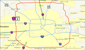
shields=
length_mi=83.13Texas Department of Transportation , [http://www.dot.state.tx.us/tpp/hwy/sl/sl0008.htm Highway Designation File - State Highway Beltway 8] ]
length_km=133.78
formed=1969
dir1=CCW
dir2=CW
from=
junction=
to= east of Houston
previous_type=Loop
previous_route=7
next_type=Loop
next_route=9Beltway 8 (BW8), the Sam Houston Parkway, along with the Sam Houston Tollway, is a
beltway around the city ofHouston, Texas ,United States , lying entirely within Harris County. Beltway 8, astate highway , runs mostly along thefrontage road s, only using the main lanes where they are free (mostly on the north side of Houston). The main lanes elsewhere are the Sam Houston Tollway, atoll road owned and operated by theHarris County Toll Road Authority (HCTRA). East of Houston, the Tollway crosses theHouston Ship Channel on theSam Houston Ship Channel Bridge , atoll bridge ; this forms a gap in Beltway 8 between Interstate Highway 10 (Baytown-East Freeway ) and State Highway 225 (La Porte Freeway).As of
2006 , the main lanes are not completed in the northeast quadrant, roughly between U.S. Highway 59 (Eastex Freeway) and U.S. Highway 90 (Crosby Freeway). This section was originally to be completed between 2007 and 2009, but funding issues threaten to delay its completion. [ [http://www.chron.com/disp/story.mpl/metropolitan/moveit/3926896.html Plans for Beltway 8 near Fall Creek fuzzy] . Rad Sallee,Houston Chronicle . June 5, 2006. Last accessed November 9, 2006.]Beltway 8 is the intermediate beltway in the Houston area. The inner beltway - Interstate Highway 610 - lies completely within Houston (except for an approximate two mile stretch that runs through the City of Bellaire), and the outer beltway - State Highway 99 (
Grand Parkway ) - is nowhere near complete.Portions of the West Belt, as sections of the Beltway are called by their compass names, are in various stages of expansion due to high traffic volumes.
The Tollway's construction was piecemealed from the opening of the West Belt in the mid-1970s to the completion of the South Belt in the mid-1990s. The Jesse H. Jones Memorial Bridge, the Tollway's crossing of the
Houston Ship Channel , was constructed by the then-Texas Turnpike Authority (TTA) and was opened in 1982.Like other toll roads in the Houston area, the speed limit is 65 mph on the freeway portions.
Despite recent speculation about the possibility of the Sam Houston Tollway being sold by HCTRA to a private firm, the Harris County Commissioners Court unanimously voted to keep the tollway in the hands of HCTRA. [ [http://www.chron.com/CDA/archives/archive.mpl?id=2006_4139374 Harris County won't sell or lease toll roads / Financial adviser suggests imitating a private company will boost profits] . Bill Murphy,
Houston Chronicle . June 21, 2006. Last accessed November 9, 2006.]As of September 3, 2007 the toll has increased by $0.25 system wide with some exceptions.
Enforcement
A number of cameras are located at toll booths to record license plate information to a database and send a ticket via mail. Recently, this system has been upgraded to alert local authorities if a the vehicle has been flagged for any reason, including Amber Alerts. When a flagged vehicle is detected, it notifies the closest law enforcement officer to investigate. At this time, Precinct 5 Constable's and
Harris County Sheriff's Office are being notified, butHouston Police Department has shown interest and wishes to be included to be notified. The total number of cameras that are planned for the system is 35. [ [http://www.chron.com/disp/story.mpl/front/5676835.html Toll road cameras looking beyond scofflaw drivers] ]Free sections
The longest free section of main lanes is on the north side of Houston, stretching from Ella Boulevard east to the current end of the
freeway east of U.S. Highway 59 (Eastex Freeway). This is maintained by theTexas Department of Transportation east of roughly theHardy Toll Road interchange. [Harris County Toll Road Authority , [https://www.hctra.org/tollroads_map/ Sam Houston & Hardy Toll Road Map] ] It includes the interchanges with US 59, the Hardy Toll Road, and Interstate Highway 45 (North Freeway).Three shorter free sections also exist:
*Beginning of main lanes north of Wallisville Road to Jacinto Port Boulevard, including the Interstate Highway 10 (Baytown-East Freeway ) interchange
*State Highway 3 (Galveston Road) to Beamer Road, including the Interstate Highway 45 (Gulf Freeway ) interchange
*West Airport Boulevard to Beechnut Street, including the U.S. Highway 59 (Southwest Freeway) interchangeThese all exist in order to allow federal funding to have been used to build the freeway-to-freeway interchanges at the Baytown-East, Gulf and Southwest Freeways.Fact|date=February 2007
The
frontage road s are generally continuous, and allow for slower free travel along the tolled segments. Only one break exists in the frontage roads; there are also several locations where one must turn to stay on them:
*Jacinto Port Boulevard to State Highway 225 - the frontage roads do not cross theHouston Ship Channel (and thus that piece of Beltway 8 was removed in 1978)Texas Department of Transportation , [http://www.dot.state.tx.us/tpp/hwy/sl/sl0008.htm Highway Designation File - State Highway Beltway 8] ]
*Deerwood Drive to Boheme Drive - both directions are on the east side of the Tollway for the crossing ofBuffalo Bayou
*West Little York Road to U.S. Highway 290 (Northwest Freeway) - both directions shift to the west side, intersecting US 290 at Senate Avenue, northwest of the Tollway
*At the Katy Freeway, some of the frontage road lanes will bypass the intersection, allowing vehicles on the frontage road to travel through the interchange without stopping at traffic lights. [ [http://www.katyfreeway.org/images/schematics_pdf/58.pdf Schematic Layout: IH 10 Katy Freeway (at Beltway 8)] TxDOT. June 19, 2003. Last accessed October 14, 2006. Note: Bypass feeder lanes are in dark purple; non-bypass feeder lanes are in dark blue and are beneath the bypass lanes.] [ [http://www.oscarmail.net/video/10w_construction_11-28-2005_best97_360x240.wmv Interstate 10: Construction, Loop 610 to BW8 (VIDEO)] . Erik Slotboom, www.houstonfreeways.com. December 30, 2005. Last accessed October 14, 2005.]Lane configuration
The lane count is for mainlanes only, unless otherwise noted. Starting at U.S. Highway 290, and moving in a clockwise direction, mainlane counts are as follows:
* 3 lanes each way between U.S. Highway 290 and State Highway 249 (work started in late 2006 to add a fourth lane in the clockwise direction)
* 4 lanes each way between State Highway 249 and Interstate 45
* 3 lanes each way between Interstate 45 and J.F.K Boulevard
* 4 lanes each way between J.F.K Boulevard and U.S. Highway 59 (Eastex Freeway)
* 3 feeder lanes each way between U.S. Highway 59 and Tidwell Road
* 3 feeder lanes each way between Tidwell Road and U.S. Highway 90
* 2 lanes each way between U.S. Highway 90 and Wallisville Road
* 3 lanes each way between Wallisville Road and Interstate 10
* 2 lanes each way between Interstate 10 and State Highway 3 (Galveston Road)
* 3 lanes each way between State Highway 3 (Galveston Road) and Beamer Road
* 2 lanes each way between Beamer Road and U.S. Highway 59 (Southwest Freeway)
* 4 lanes each way between U.S. Highway 59 and U.S. Highway 290 (portions between Highway 59 and Westpark Tollway)Exit list
Clockwise reads down and counterclockwise reads up.
References
External links
* [http://www.hctra.com Harris County Toll Road Authority]
* [http://www.texasfreeway.com/Houston/photos/bw8/bw8.shtml TexasFreeway - Beltway 8 / Sam Houston Tollway Stacks and Other Interesting Features]

Wikimedia Foundation. 2010.