- Texas State Highway Loop 1
-
State Highway Loop 1

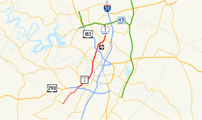
Route information Length: 25.698 mi[1] (41.357 km) Existed: 1967 – present Major junctions South end:  SH 45
SH 45 US 290
 SH 71
SH 71
 US 183
North end:  SH 45
SH 45Highway system Highways in Texas
Interstate • U.S. • TX (Loops – Spurs – Rec – FM)←  Loop 1604
Loop 2  →
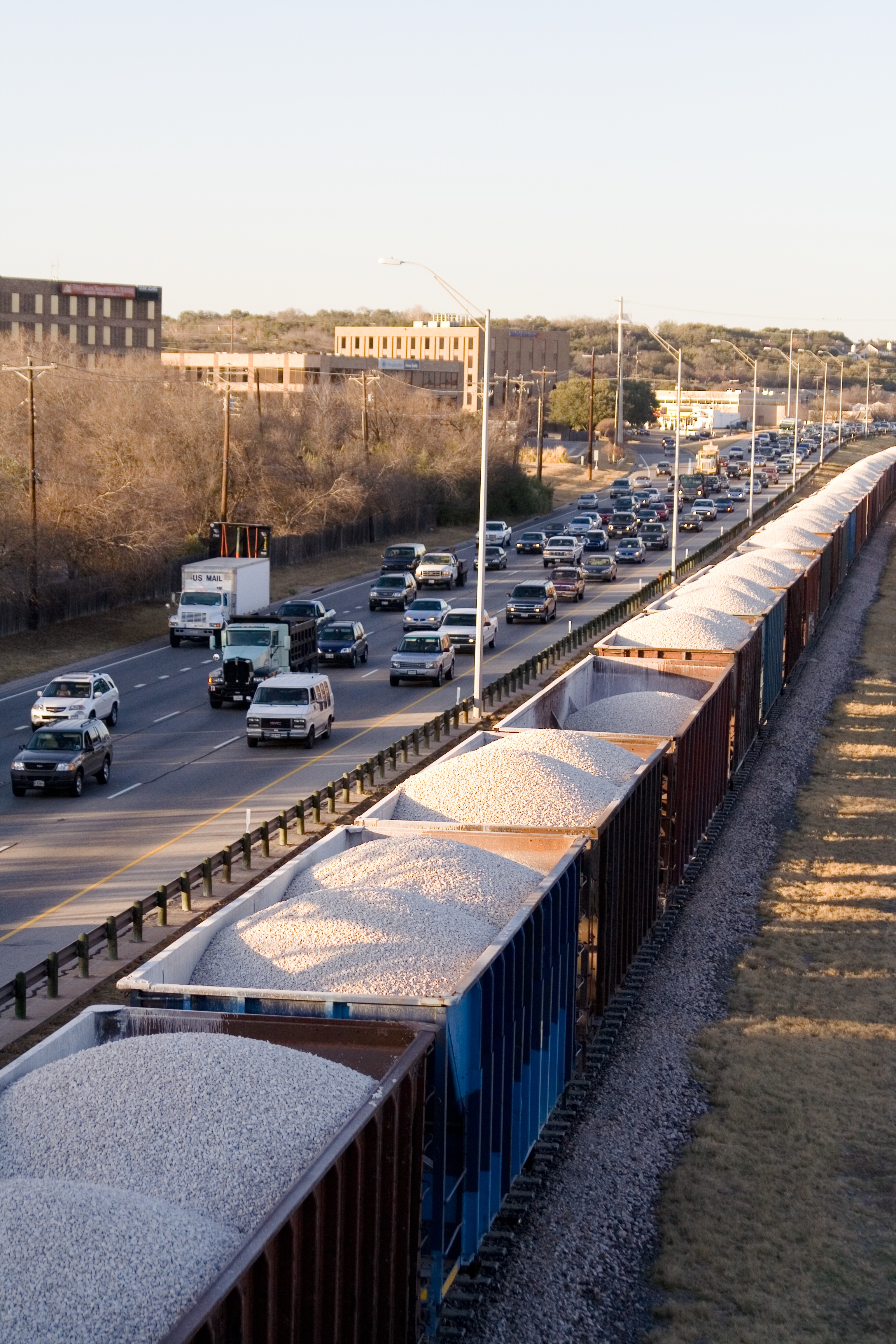
→Loop 1 is a controlled-access highway which provides access to the west side of Austin in the U.S. state of Texas. It is named Mopac Expressway (or, according to some highway signs, Mopac Boulevard) after the Missouri Pacific Railroad (or "MoPac"). The original section of the highway was built in the 1970s along the right-of-way of the Missouri Pacific Railroad (now owned by Union Pacific), with the railroad tracks running in the highway median between West 8th Street and Northland Drive. To the north, the tracks run along the east side of newer sections of the highway from Northland Drive to Braker Lane.
Contents
History
The first mention of Loop 1 came to public record in 1929. In 1944, the C.M.A.C (City of Austin Planning Commission) proposed the highway be built in parts of under-utilized right of way owned by the MoPac railroad. The highway was eventually given the nickname "MoPac" for its proximity to the railroad. The number was originally used for Texas State Highway Spur 1 designated by 1939 from US 90 to the Uvalde fish hatchery. This route was cancelled in 1943. In 1958, a new route was designated, also called Spur 1, from US 80A to IH 10. This route became Loop 16 in 1964.[1] Loop 1 was first designated in October 1967 from U.S. Highway 290 (US 290) northward to Farm to Market Road 1325 (FM 1325). In October 1985, the designation was extended southward from US 290 to SH 45.[1] In the year 1982 construction on the highway was completed from Research Boulevard to Texas State Highway Loop 360. The northern extension of Loop 1 started construction in 1986 and completed 3 years later in 1989. Construction of the extension from US 290 to SH 45 was completed in 1994. Only minor changes have taken place to Loop 1 after the extension that was completed in 1994. The MoPac 1 Project will study feasibility of managed lanes for Loop 1, and included in the Mobility 2030 Plan that was adopted by CAMPO in June 2005.[2]
Route description
Loop 1's southern terminus is at the beginning of the State Highway 45 stub south of Austin. It intersects SH 71/US 290 (Ben White Boulevard) and Loop 360 (Capital of Texas Highway). It crosses the Colorado River near downtown Austin and intersects US 183 (Research Boulevard) northwest of downtown. Loop 1 travels concurrently with Farm to Market Road 1325 for several miles before the non-tolled freeway ends at Parmer Lane, spanning a distance of 22.061 miles (35.504 km).
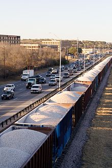 A stretch of Loop 1 in Austin. The Union Pacific railway is visible in the foreground.
North of Parmer Lane, Loop 1 continues as a limited-access toll road to the SH 45 North/Loop 1 interchange, spanning 3 miles (4.8 km). Frontage roads flank either side of the toll road to Shoreline Drive.
The Texas Department of Transportation completed construction of the tollway as part of the 2002 Central Texas Turnpike Project (CTTP). SH 45 North, also part of the project, provides freeway access to Interstate 35 from Loop 1. The 2002 CTTP was scheduled to be completed in September 2007. However, certain sections of the project, including Loop 1 opened early and more than $100 Million under budget.
If and when SH 45 is completed to the south of Austin, Loop 1 will effectively serve as a true loop to the west of the city, being directly connected to SH 45, and indirectly to I-35, at both ends.
Since 1994, TxDOT has proposed the addition of managed lanes to portions of Loop 1. The MoPac Improvement Project[3] was relaunched in July 2010. In December 2010, four alternative proposals were presented to the public, each of which would add one or more lanes; the "no-build" alternative was also presented. The additions would not increase the right-of-way of the highway, but would be created by reducing the width of existing lanes and reducing and/or eliminating shoulders.
Exit list
There are no mileposts associated with this highway.
County Location Destinations Notes Travis Austin SH 45La Crosse Avenue Slaughter Lane South end of freeway Davis Lane Southbound exit and northbound entrance William Cannon Drive US 290 / SH 71 / Southwest Parkway – Johnson City, Llano, Sunset ValleyFrontage Road Southbound exit only  Loop 360 (Capital of Texas Highway)
Left hand exit Barton Skyway  RM 2244 – West Lake Hills, Rollingwood
Cesar Chavez Street 5th Street, Lake Austin Boulevard Enfield Road Windsor Road Westover Road, Northwood Road 35th Street 45th Street  RM 2222 (Northland Drive)
Far West Boulevard Anderson Lane, Spicewood Springs Road Southbound exit is via Steck Avenue exit Steck Avenue (Frontage Road) Unsigned exit US 183 (Research Boulevard)Southbound exit to US 183 north is via Capital of Texas Hwy Capital of Texas Highway To Loop 360Braker Lane  FM 1325 south (Burnet Road) / Duval Road
South end of FM 1325 overlap Waters Park Road Southbound exit and northbound entrance  FM 734 (Parmer Lane)
Scofield Ridge Parkway Northbound exit and southbound entrance. Last free exit. FM 1325 north / Wells Branch Parkway, Howard LaneNorth end of FM 1325 overlap Shoreline Drive No southbound exit Williamson SH 45Northbound exit and southbound entrance References
- ^ a b c Texas Department of Transportation, [1]
- ^ "What Native American tribe was most common in the area?". TxDot. City of Austin. http://www.txdot.gov/project_information/projects/austin/mopac1/history.htm. Retrieved 2010-01-24.
- ^ MoPac Improvement Project
- "Construction contract for Loop 1 extension awarded" (Press release). Texas Tollways. June 26, 2003. http://www.texastollways.com/tta/article.asp?itemID=25.
- "Loop 1 History". Expressway. Texas Department of Transportation. http://www.txdot.gov/project_information/projects/austin/mopac1/history.htm. Retrieved 2009-01-03.
- "State Highway Loop 1". Expressway. Texas Department of Transportation. http://www.txdot.state.tx.us/tpp/hwy/sl/sl0001.htm. Retrieved 2006-04-18.
- "Austin toll roads will open November 1" (PDF) (Press release). Central Texas Turnpike System. September 18, 2006. http://www.centraltexasturnpike.org/pdf/NR-opening%20date%20announcementI.pdf.
Travis County highways Interstates U.S. Highways State Highways State Loops and Spurs Toll Roads Farm and Ranch to Market Roads Categories:- Texas state highway loops and spurs
- Toll roads in Texas
- Freeways in Texas
- Transportation in Austin, Texas


Wikimedia Foundation. 2010.