- Texas State Highway Loop 343
Infobox TX State Highway
type=Loop
route=343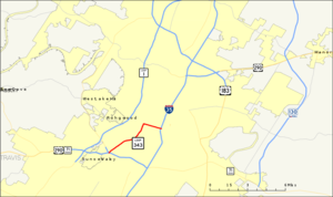
shields=
length_mi=5.186
length_ref=TxDOT|SL|343]
length_km=8.3
formed=1961
dir1=South
dir2=East
from=jct|state=TX|US|290|SH|71
to=jct|state=TX|I|35
previous_type=Spur
previous_route=342
next_type=Loop
next_route=344Loop 343 is a 5.186-mile state-maintained roadway located in
Austin, Texas .History
Loop 343 was formed in 1961 along the previous routes of SH 71 and US 290 as those roads were realigned. It passed through downtown Austin along 7th Street to Lamar Boulevard.
It was rerouted in 1977 to use 1st Street (now Cesar Chavez Street) west of I-35. In 1987, the portion east of I-35 was removed from state maintenance, forming the current alignment.
Between 1978 and 2008, a segment of Cesar Chavez Street in downtown Austin was one-way eastbound. Westbound traffic on Loop 343 was diverted to Second and Third Streets before merging back onto Cesar Chavez Street at . In 2008, as part of a larger public works project, the City of Austin converted Cesar Chavez Street back to two-way traffic along its entire lengthcite web|title=Cesar Chavez St. to go both ways|url=http://www.kxan.com/Global/story.asp?s=8789646|accessdate=2008-08-19] .
Route description
Loop 343 begins in south Austin at the intersection of US 290/SH 71 and the southern terminus of Loop 360. It proceeds north along Lamar Boulevard for 3.5 miles towards downtown Austin. Here, it crosses
Town Lake on theLamar Boulevard Bridge . This segment of Loop 343 is a four-lane heavily-developed urban road.At this point, Loop 343 heads east along
Cesar Chavez Street for 1.6 miles, past Austin City Hall and theAustin Convention Center , to its terminus at I-35. This segment of Loop 343 is a four-lane downtown road.Loop 343 is only signed as such at its entrance from US 290/SH 71. There are no shields displayed anywhere along its length, nor on its entrance from I-35.
Future
The City of Austin is planning extensive development near the former Seaholm power plant site west of the intersection of Lamar Boulevard and Cesar Chavez Street. In addition to new multi-family residences and new public arts facilities, the development will include reconfiguration of the intersection at Lamar and Cesar Chavezcite web|title=City of Austin - Seaholm District|url=http://www.ci.austin.tx.us/seaholm/|accessdate=2007-08-26] .
Junction list
References

Wikimedia Foundation. 2010.