- New York State Route 290
-
For the Interstate Highway north of Buffalo, see Interstate 290 (New York).
NYS Route 290
Route information Maintained by NYSDOT and the City of Syracuse Length: 12.40 mi[2] (19.96 km) Existed: 1930[1] – present Major junctions West end:  US 11 in Syracuse
East end:  NY 5 in Manlius
Location Counties: Onondaga Highway system Numbered highways in New York
Interstate • U.S. • N.Y. (former) • Reference • County←  I-290
I-290NY 291  →
→New York State Route 290 (NY 290) is a state highway located entirely within Onondaga County, New York, extending from downtown Syracuse to the east side of the county. It provides access to Green Lakes State Park from the north.
NY 290 is one of several state highways linking Syracuse and its eastern suburbs.
Contents
Route description
NY 290 begins at US 11 in downtown Syracuse. All of NY 290 within the city of Syracuse is maintained by the city. It follows James Street towards the Eastwood section of Syracuse. At Eastwood, it intersects NY 598 (Midler Avenue). NY 290 continues east and has a junction with NY 635 (Thompson Road).
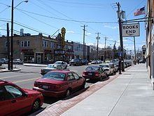 NY 290 in the Eastwood neighborhood of Syracuse
Shortly after its junction with NY 635, NY 290 enters the village of East Syracuse as West Manlius Street. In the village of East Syracuse, NY 290 approaches a fork in the road, and veers to the right on Bridge Street. After a bridge over the CSX Transportation-owned Mohawk Subdivision railroad line, NY 290 approaches an intersection with Manlius Center Road to the left, Bridge Street to the right and Chevy Drive straight ahead. NY 930P (an unsigned reference route) continues to the right as Bridge Street, towards Interstate 690, and NY 5. NY 290 continues to the left on Manlius Center Drive, towards the town of Manlius.
Shortly after passing under the Interstate 481 bridge, NY 290 enters the town of Manlius. NY 290 passes through a residential section of Manlius, called Fremont Heights. NY 290 passes Fremont Road, North Burdick Street, and Minoa Road. It then stops at a T-shaped intersection, at the northern terminus of NY 257, which leads to Fayetteville. NY 290 continues to the left as Green Lakes Road.
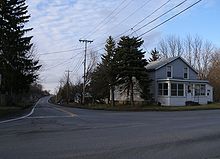 NY 290 stretching away from terminus on NY 5 at Mycenae
NY 290 eventually passes Green Lakes State Park in Manlius, and then reaches its eastern terminus at NY 5 in the hamlet of Mycenae.
History
The entirety of NY 290 was assigned as part of the 1930 renumbering of state highways in New York.[1][3]
Major intersections
The entire route is in Onondaga County.
Location Mile[2] Destinations Notes Syracuse 0.00 US 11 NY 598
3.30  NY 635
East Syracuse 4.71 Bridge Street (NY 930P) To I-481 via I-690 Town of Manlius 8.33  NY 257
Northern terminus of NY 257 12.40 NY 5Hamlet of Mycenae 1.000 mi = 1.609 km; 1.000 km = 0.621 mi References
- ^ a b Standard Oil Company of New York (1930). Road Map of New York (Map). Cartography by General Drafting.
- ^ a b "2008 Traffic Volume Report for New York State" (PDF). New York State Department of Transportation. June 16, 2009. p. 207. https://www.nysdot.gov/divisions/engineering/technical-services/hds-respository/NYSDOT%20TVR%202008%20by%20Route.pdf. Retrieved February 1, 2010.
- ^ Automobile Legal Association (ALA) Automobile Green Book, 1930/31 and 1931/32 editions, (Scarborough Motor Guide Co., Boston, 1930 and 1931). The 1930/31 edition shows New York state routes prior to the 1930 renumbering
External links
Categories:- State highways in New York
- Transportation in Onondaga County, New York
- Transportation in Syracuse, New York


Wikimedia Foundation. 2010.