- New York State Route 257
-
NYS Route 257
Route information Maintained by NYSDOT Length: 3.82 mi[3] (6.15 km) Existed: 1940s[1][2] – present Major junctions South end:  NY 92 in Manlius village
North end:  NY 290 in Manlius town
Location Counties: Onondaga Highway system Numbered highways in New York
Interstate • U.S. • N.Y. (former) • Reference • County←  NY 256
NY 258  →
→New York State Route 257 (NY 257) is a state highway in eastern Onondaga County, New York, in the United States. It runs from a junction with NY 92 near the village of Manlius through downtown Fayetteville to an intersection with NY 290 at Manlius Center. The path of NY 257 has been state-maintained since 1918; however, the NY 257 designation only dates back to the 1940s, when it was assigned to the portion of its modern alignment north of Fayetteville. The remainder, originally part of NY 92, became part of NY 257 in the early 1960s.
Contents
Route description
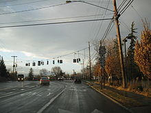 South end of NY 257 at NY 92 in Manlius
Route 257 begins at NY 92 in Manlius. Known as Fayetteville–Manlius Road, it proceeds northwest to Fayetteville, where it becomes South Manlius Street as it passes near the Fayetteville Cemetery. At an intersection with Route 5 in the center of the village, NY 257 becomes North Manlius Street. Just outside Fayetteville in the town of Manlius, it intersects County Route 56 and crosses a small stream before becoming North Manlius Road. From this point northward, NY 257 parallels an old alignment of the Erie Canal (as well as the surrounding Old Erie Canal State Park) to Manlius Center, where it ends at NY 290.[4]
History
All of what is now NY 257 was originally added to the state highway system on August 14, 1918, as part of State Highway 1073 (SH 1073), an unsigned legislative designation still used today for inventory purposes.[5] In the 1930 renumbering of state highways in New York, the section of SH 1073 south of Fayetteville became part of NY 92.[6][7] The portion of the route north of Fayetteville remained unnumbered until the 1940s when it was designated as NY 257.[1][2] In the early 1950s, what is now NY 92 from DeWitt to Manlius was designated as part of NY 20SY.[8][9] The NY 20SY designation was eliminated ca. 1962,[10][11] at which time NY 92 was realigned to bypass Fayetteville by way of NY 20SY's former routing southwest of the village. The former alignment of NY 92 between Fayetteville and Manlius became a southward extension of NY 257.[12][13]
Major intersections
The entire route is in Onondaga County.
Location Mile[3] Destinations Notes Village of Manlius 0.00 NY 92Fayetteville 1.92  NY 5
NY 5Town of Manlius 3.82 NY 290Hamlet of Manlius Center 1.000 mi = 1.609 km; 1.000 km = 0.621 mi References
- ^ a b Gulf Oil Company (1940). New York Info-Map (Map). Cartography by Rand McNally and Company.
- ^ a b Texas Oil Company (1946). New York with Pennsylvania (Map). Cartography by Rand McNally and Company.
- ^ a b "2008 Traffic Data Report for New York State" (PDF). New York State Department of Transportation. June 16, 2009. p. 279. https://www.nysdot.gov/divisions/engineering/technical-services/hds-respository/NYSDOT_Traffic_Data_Report_2008.pdf. Retrieved January 10, 2010.
- ^ Google, Inc. Google Maps – overview map of New York State Route 257 (Map). Cartography by Google, Inc. http://maps.google.com/maps?hl=en&q=from:+N%20Manlius%20Rd/RT-257%20@43.053050,%20-76.000610+to:+Fayette%20St/RT-257%20@43.005806,%20-75.984231. Retrieved February 13, 2008.
- ^ New York State Department of Highways (1920). Report of the State Commissioner of Highways. Albany, New York: J. B. Lyon Company. p. 252. http://books.google.com/books?id=Sj4CAAAAYAAJ&pg=PA252. Retrieved June 24, 2010.
- ^ Standard Oil Company of New York (1929). New York in Soconyland (Map). Cartography by General Drafting.
- ^ Dickinson, Leon A. (January 12, 1930). "New Signs for State Highways". The New York Times: p. 136.
- ^ Socony-Vacuum Oil Company (1950). New York (Map). Cartography by Rand McNally and Company.
- ^ Sunoco (1952). New York (Map). Cartography by Rand McNally and Company.
- ^ Sunoco (1961). New York and Metropolitan New York (Map). Cartography by H.M. Gousha Company (1961–62 ed.).
- ^ Esso (1962). New York with Sight-Seeing Guide (Map). Cartography by General Drafting.
- ^ Esso (1958). New York with Special Maps of Putnam–Rockland–Westchester Counties and Finger Lakes Region (Map). Cartography by General Drafting (1958 ed.).
- ^ United States Geological Survey (1962). Utica, NY Quadrangle (Map). 1:250,000. Eastern United States 1:250,000. http://www.lib.utexas.edu/maps/topo/250k/txu-pclmaps-topo-us-utica-1962.jpg. Retrieved December 30, 2009.
External links
Categories:- State highways in New York
- Transportation in Onondaga County, New York


Wikimedia Foundation. 2010.