- Departments of Colombia
-
Colombia 
This article is part of the series:
Politics and government of
ColombiaConstitutionLegislatureExecutiveElectionsDivisions- Departments
- Municipalities
- Major parties
- Liberal Party
- Conservative Party
- Social Party of National Unity
- Radical Change Party
- Alternative Democratic Pole
- Green Party
- MIRA
Related issues
Colombia is an unitary republic formed by thirty-two departments (Spanish: departamentos, sing. departamento) and a Capital District (Distrito Capital). Each department has a Governor (gobernador) and a Department Assembly (Asamblea Departamental), elected by popular vote for a four-year period. The governor cannot be re-elected in consecutive periods. Departments are country subdivisions and are granted a certain degree of autonomy.
Departments are formed by a grouping of municipalities (municipios, sing. municipio). Municipal government is headed by mayor (alcalde) and administered by a Municipal Council (concejo municipal), both of which are elected for four-year periods.
The Capital District is the country's capital, Bogotá. Bogotá is partially dependent on the Cundinamarca Department that surrounds it.
Contents
Chart of departments
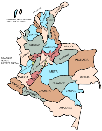
Each one of the departments of Colombia in the map below links to a corresponding article.
Department Capital Area (km²) Population Date of establishment * Bogotá, Distrito Capital 1,587 7,117,984 August 6, 1538 1 Amazonas Leticia 109,665 80,360 October 5, 1991 2 Antioquia Medellín 63,612 5,750,478 1826 3 Arauca Arauca 23,818 282,302 July 4, 1991 4 Atlántico Barranquilla 3,388 2,365,663 1910 5 Bolívar Cartagena 25,978 2,229,967 June 15, 1857 6 Boyacá Tunja 23,189 1,411,239 1858 7 Caldas Manizales 7,888 1,170,187 1905 8 Caquetá Florencia 88,965 463,333 1982 9 Casanare Yopal 44,640 325,713 July 4, 1991 10 Cauca Popayán 29,308 1,363,054 June 15, 1857 11 Cesar Valledupar 22,905 1,050,303 December, 1967 12 Chocó Quibdó 46,530 413,173 November 3, 1947 13 Córdoba Montería 25,020 1,392,905 June 18, 1952 14 Cundinamarca Bogotá 24,210 *9,467,562 June 15, 1857 15 Guainía Inirida 72,238 43,314 July 13, 1963 16 Guaviare San José del Guaviare 53,460 133,236 July 4, 1991 17 Huila Neiva 19,890 994,218 1905 18 La Guajira Riohacha 20,848 524,619 July 1, 1965 19 Magdalena Santa Marta 23,188 1,403,318 July 25, 1824 20 Meta Villavicencio 85,635 771,089 July 1, 1960 21 Nariño Pasto 33,268 1,775,139 August 6, 1904 22 Norte de Santander Cúcuta 21,658 1,493,932 July 25, 1910 23 Putumayo Mocoa 24,885 378,483 1991 24 Quindío Armenia 1,845 613,375 July 1, 1966 25 Risaralda Pereira 4,140 1,024,362 July 1, 1966 26 San Andrés and Providencia San Andrés 52 83,491 July 4, 1991 27 Santander Bucaramanga 30,537 2,085,084 May 13, 1857 28 Sucre Sincelejo 10,917 868,648 August 18, 1966 29 Tolima Ibagué 23,562 1,312,972 August 4, 1886 30 Valle del Cauca Cali 22,140 4,524,678 April 16, 1910 31 Vaupés Mitú 54,135 33,152 July 4, 1991 32 Vichada Puerto Carreño 100,242 97,276 July 5, 1991 * Estimate includes the country's capital, Bogotá. Maps gallery
-
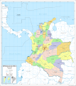
Map of the Departments of Colombia with Municipalities.
See also
- ISO 3166-2:CO
- List of Colombian flags
- List of country subdivisions
- List of political and geographic subdivisions by total area
- States of Colombia
External links
- (French) List of Colombian departments governors
- Departments of Colombia at statoids.com
Categories:- Departments of Colombia
- Subdivisions of Colombia
- Lists of country subdivisions
- Country subdivisions of the Americas
- First-level administrative country subdivisions
- Colombia-related lists
Wikimedia Foundation. 2010.


