- Cesar Department
-
For other uses, see Cesar (disambiguation).
Department of Cesar
Departamento del Cesar— Department — 
Flag
Coat of armsAnthem: Himno del Cesar Cesar shown in red
Coordinates: 10°29′N 73°15′W / 10.483°N 73.25°WCoordinates: 10°29′N 73°15′W / 10.483°N 73.25°W Country  Colombia
Region Caribbean Region Established December 1967 Capital Valledupar Government - Governor Cristian Moreno Panezo (Green Party of Colombia Option Center) Area - Total 22,925 km2 (8,851.4 sq mi) Area rank 22 Population (2005)[1] - Total 879,914 - Rank 15 - Density 38.4/km2 (99.4/sq mi) Time zone UTC-05 ISO 3166 code CO-CES Provinces Municipalities Website www.gobcesar.gov.co Cesar Department (Spanish: Departamento del Cesar) or simply Cesar is a department of Colombia located in the north of the country in the Caribbean region, bordering to the north with the Department of La Guajira, to the west with the Department of Magdalena and Department of Bolivar, to the south with Department of Santander, to the west with the Department of North Santander, and to the east with the country of Venezuela (Zulia State). The department capital city is Valledupar.[2]
The region was first inhabited by indigenous peoples known as Euparíes in the Valley of Upar and Guatapuríes in the Valley of the Cesar river, among these were the Orejones pertaining to the Tupe, Acanayutos pertaining to the Motilones and Alcoholados pertaining to the Chimilas. The first European to explore the area was Spanish Captain Pedro de Vadillo, but German Ambrosio Alfínger savagely conquered the region in 1532.[3] In 1550 the village of Valle de Upar was founded by Hernando de Santana and Juan de Castellanos.[4]
In 1813, María de la Concepción Loperena proclaimed the independence in Valledupar and donated 300 horses to Simon Bolivar. In 1829 Valledupar became a cantón of the province of Santa Marta. By Law 15 of 1850, Valledupar was segregated from Santa Marta becoming the province of Valledupar. In 1857 became a province of the state of Magdalena and by Law of December 29, 1864 became the department of Valledupar pertaining to state of Magdalena. On December 27, 1967 the department of Cesar was created officially.[3]
Contents
Etymology
The "Cesar" name is an adaptation from the Chimila indigenous word Chet-tzar or Zazare ("calm water") into Spanish, in reference to the Cesar River. The valley that its basin covers is also named after the river and extends through most of the department. The department of Cesar was created in 1967 by decree and the name officially adopted.[5]
Geography
Main article: Geography of Cesar Department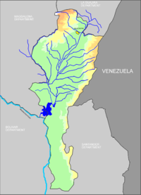 The Cesar River basin in the department of Cesar.
The department of Cesar is located in northern Colombia bordering to the north with the department of La Guajira, to the east with the Bolivarian Republic of Venezuela, to the west with the department of Magdalena, to the southwest with the Department of Bolivar and to the south with the departments of North Santander and Santander covering a total area of 22,905 km².[6]
The majority of the Department is flat in 57% of the total area and 43% mountainous mainly in the Serrania del Perija and the Sierra Nevada de Santa Marta mountain ranges.[6]
Ecoregions
The Department of Cesar contains five Ecoregions; the Serrania del Perija mountain range, the valley of the Cesar River, the Sierra Nevada de Santa Marta mountain range, the valley of the Magdalena River and the Cienaga de Zapatosa marshes complex.[6]
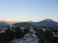
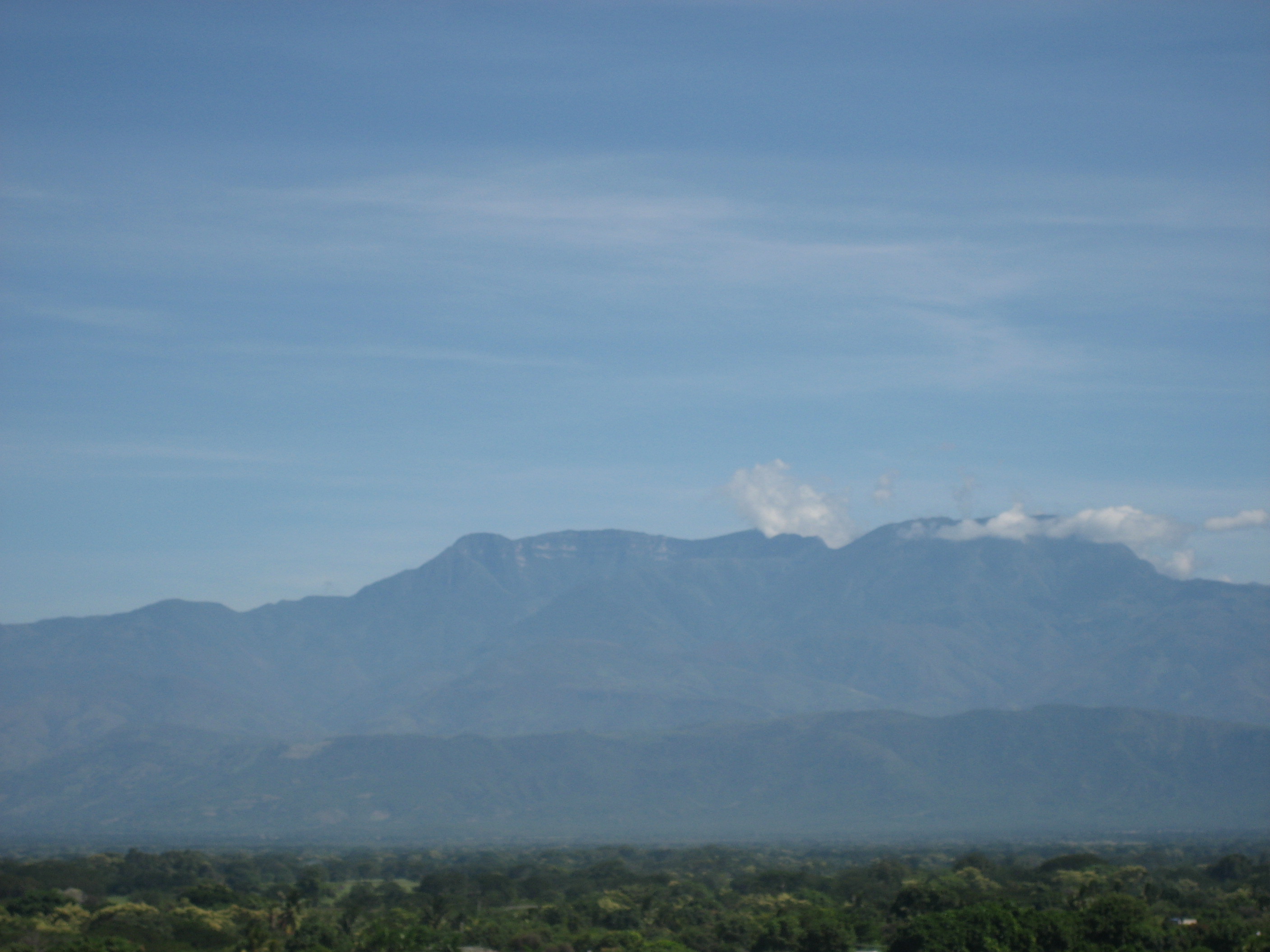
 Cerro Pintao and the Serrania del Perija.
Serrania del Perija mountain range
The Serrania del Perija mountain range covers most of the eastern side of the Department of Cesar between its border with Venezuela and the Department of North Santander, approximately 300 km in length penetrating into the Department of La Guajira to the north and covering 27% of the total area of Cesar. The Serrania del Perija covers, partially or totally the area of 17 municipalities in the Department of Cesar; Aguachica, Codazzi, Becerril, Chimichagua, Chiriguana, Curumani, Gonzalez, La Gloria, La Jagua de Ibirico, Los Robles La Paz, Manaure, Pailitas, Pelaya, Rio de Oro, San Alberto, San Diego and San Martin. There are also the indigenous reserves pertaining to the Yukpas people; Iroka, Socorpa and Menkue-Misaya-La Pista; and to the Wiwas people; Caño Padilla, El Rosario-Bella Vista-Yucatán and Campoalegre.[7]
Approximately 70% of the mountain range preserves unique flora and fauna and some 20 rivers are born in the mountain range among other minor streams, flowing into the Department of Cesar and feeding the Magdalena and Cesar river basins and the Cienaga de Zapatosa marshes. The Colombian government declared it a National Forest Reserve.[7]
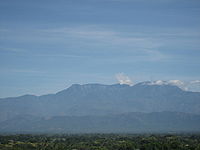
Sierra Nevada de Santa Marta mountain range
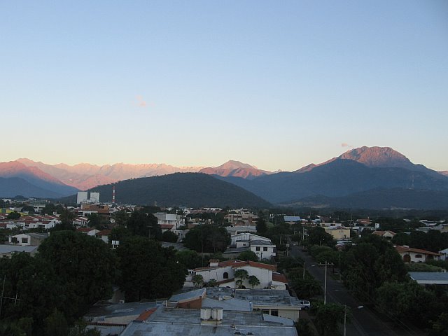
 The Sierra Nevada de Santa Marta as seen from Valledupar.
The Sierra Nevada de Santa Marta mountain range is an isolated mountain range located in the northwestern region of the Department of Cesar. The mountain range is shared with by Department of La Guajira, which covers the northern area, the Department of Magdalena to the western side and the Department of Cesar which covers the southern face, covering a total area of 16,615 km² (1'661,500 ha) of which 380,000 ha pertain to the Department of Cesar. The Cesar River and the western side of its basin is born on the Sierra Nevada de Santa Marta, including the Guatapuri, Badillo, Ariguani, Cesarito, Los Clavos, Garupal and Rio Seco rivers. The mountains are within the boundaries of the municipalities of Pueblo Bello, Valledupar, El Copey and Bosconia. [8]
The Sierra Nevada de Santa Marta was declared by UNESCO as a Biosphere Reserve on October 29, 1993.[9]
Valley of the Cesar river
Valley of the Magdalena river
Cienaga de Zapatosa marshes
Climate
Climate in the Department of Cesar presents variations in climate depending on altitude, as well as rainfall precipitations. Mountain climate in the Sierra Nevada de Santa Marta and the Serrania del Perija cools downs the higher the altitude reachin freezing low temperatures at the snowy peaks and the region has two rainy seasons and two dry seasons, averaging a temperature throughout the year of 28°C.[10] Lower lands present a warm and dry climate, annual precipitations are less than 1,300 mm a year. The mountainous regions are characterized by low temperatures with snow at high altitude peaks and precipitations ranging more than 2,000 mm a year.
Climate data for Valledupar Month Jan Feb Mar Apr May Jun Jul Aug Sep Oct Nov Dec Year Average high °F (°C) 94.5
(34.7)96.1
(35.6)96.6
(35.9)96.1
(35.6)93.2
(34.0)93.6
(34.2)95.7
(35.4)95.2
(35.1)92.8
(33.8)90.7
(32.6)91.8
(33.2)92.5
(33.6)93.6
(35.1)Average low °F (°C) 72.3
(22.4)73.6
(23.1)74.5
(23.6)75.4
(24.1)75.4
(24.1)75.2
(24.0)75.6
(24.2)75.2
(24.0)74.3
(23.5)74.5
(23.6)73.6
(23.1)73.0
(22.8)74.3
(23.6)Precipitation inches (mm) 0.47
(12)0.39
(10)1.02
(26)2.8
(71)6.06
(154)3.23
(82)2.48
(63)4.57
(116)4.8
(122)7.83
(199)3.5
(89)1.1
(28)38.27
(972)Source: Weatherbase[11][12] History
Pre-Columbian
The region was first inhabited by indigenous peoples known as Euparíes in the Valley of Upar and Guatapuríes in the Valley of the Cesar river, among these were the Orejones pertaining to the Tupe, Acanayutos pertaining to the Motilones and Alcoholados pertaining to the Chimilas.
Spanish chronicles describe the tribes as being part of a federation of tribes led by Caciques, with the village of Eupari as the largest and central to the other villages. These tribes are believed to be related to the Mesoamerican culture, the Caribs and Arawaks, directly associated to the Muisca culture in the Colombian eastern branch of the Andes.[13]
Archeological findings has shown that the indigenous in the area worked with stones and wood, including a boomerang shaped weapon found in a cemetery at Los Robles La Paz.[14]
Spanish conquest and colonization
The first European to explore the area was Spanish Captain Pedro de Vadillo, but German Ambrosio Alfínger savagely conquered the region in 1531.[3][15] In 1550 the village of Valle de Upar was founded by Hernando de Santana and Juan de Castellanos.[4]
Republican era
In 1813, María de la Concepción Loperena proclaimed the independence of Valledupar and donated 300 horses to Simon Bolivar. In 1829 Valledupar became a Cantón of the Province of Santa Marta. By Law 15 of 1850, Valledupar was segregated frim Santa Marta becoming the Province of Valledupar. In 1857 became a province of the State of Magdalena and by Law of December 29, 1864 became the Department of Valledupar pertaining to State of Magdalena. On December 27, 1967 the Department of Cesar was created officially.[3]
Politics
Government and Politics
Governors
Main article: Governor of Cesar DepartmentDepartment Assembly
Main article: Department Assembly of CesarAdministrative Divisions
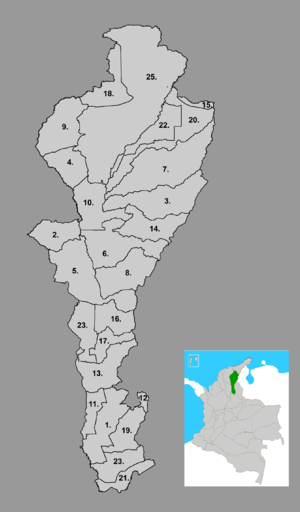
Municipalities
See also: Municipalities of ColombiaThe Department of Cesar is formed by 25 municipalities, some 171 corregimientos, 990 veredas and 10 indigenous reserves.[16] For administrative reasons the Department of Cesar is subdivided into 4 strategic regions; the Northern Subregion covering the municipalties of Valledupar, Codazzi, Pueblo Bello, La Paz, Manaure and San Diego. The Northwestern Subregion covering the municipalities of Bosconia, El Copey, El Paso and Astrea. The Central Subregion covering the municipalities of Curumani, Becerril, Chiriguana, La Jagua de Ibirico, Chimichagua, Tamalameque and Pailitas; and the Southern Subregion covering the municipalities of Aguachica, Gamarra, Gonzalez, La Gloria, Pelaya, Rio de Oro, San Alberto and San Martin.[6]
Municipalities Map  Aguachica
 Astrea
 Becerril
 Bosconia
 Chimichagua
 Chiriguana
 Codazzi
 Curumani
 El Copey
 El Paso
 Gamarra
 González
 La Gloria
 La Jagua de Ibirico
 Manaure
 Pailitas
 Pelaya
- Pueblo Bello
 Rio de Oro
 Robles La Paz
 San Alberto
 San Diego
 San Martín
 Tamalameque
 Valledupar
Economy
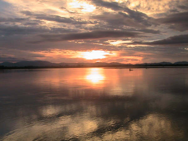
 Ciénaga de la Zapatosa marsh by La Gloria, southern Cesar Department
The economy of the César Department is sustained by the agricultural sector, secondly by a services industry following with commercial industry and mining. Cattle raising is exploited extensively (using large farms), and for this reason large portions of forests have been chopped off to create corrals. In agriculture, plantations of cotton, rice, sugar cane, oil palm, cassava and plantain. Services are centered on commerce and the industry is represented by oil products, fats and milk derived products. As one of the biggest water resources areas of Colombia, if not America, part of the Magdalena River crosses the Department and helps create the Cienaga de Zapatosa (Zapatosa Marsh) along with the Cesar river. It has a great potential to develop a fishing industry also, but it is practiced at a minimum. Most of the territory has not been explored in the search of more minerals due to violence, but because of recent findings, it became a potential source.[1]
Notes
- ^ http://www.dane.gov.co/files/censo2005/regiones/cesar/cesar.pdf
- ^ (Spanish) Valledupar official website, Capital of the Department of Cesar
- ^ a b c d (Spanish) Agustin Codazzi Geographic Institute: History of Cesar
- ^ a b LABLAA: Department of Cesar; History
- ^ (Spanish) LABLAA - Luis Galvis: Don Gonzalo
- ^ a b c d (Spanish) Government of the Department of Cesar: The Territory
- ^ a b (Spanish) Government of the Department of Cesar: Serrania del Perija
- ^ (Spanish) Government of the Department of Cesar: Sierra Nevada de Santa Marta
- ^ (Spanish) UNESCO: Buritaca 200 - Ciudad Perdida - Sierra Nevada de Santa Marta
- ^ (Spanish) Agustin Codazzi Geographic Institute: Climate of the Department of Cesar
- ^ "Worldweather: Valledupar, Colombia". Weatherbase. 2008. http://www.worldweather.org/057/c00889.htm=. Retrieved 2008-04-08.[dead link]
- ^ *Climatological information is based on monthly averages for the 30-year period 1971-2000.
- Precipitation includes both rain and snow.
- Attention: Please note that the averaging period for climatological information and the definition of "Mean Number of Precipitation/Rain Days" quoted in this web site may be different for different countries. Hence, care should be taken when city climatologies are compared.
- ^ Castro Trespalacios 1979, p. 22
- ^ Castro Trespalacios 1979, p. 23
- ^ Castro Trespalacios 1979, p. 21
- ^ Government of Colombia: Human Rights in the Department of Cesar; municipalities
References
- Dangon Ovalle, Jaime (November 1987), El Cesar, Hijo del Amor, Valledupar: Departamento del Cesar.
- Gutierrez Hinojosa, Tomas Dario (2000), Valledupar Musica de una Historia, Bogota: Editorial Grijalbo LTDA, ISBN 958-639175-2
- Araujonoguera, Consuelo (2002), Trilogia Vallenata, Colombia: Proyecto Editorial Babilonia, ISBN 958-33-3360-3
- Castro Trespalacios, Pedro (1979), Culturas Aborigenes Cesarences e Independencia de Valle de Upar, Bogota: Casa de la Cultura de Valledupar
External links
- Cesar 30 Años de Progreso - Gobernacion del Cesar (1997) booklet
- Cesar Department official website
- INGEOMINAS: Geography of the Department of Cesar
- Poverty in the Department of Cesar
- Forced displacement in the Department of Cesar
 Department of Cesar
Valledupar (capital)Geography Climate | Mountains | Rivers | Fauna | Flora | Protected areas | Environmental issues |
Timeline | Province of Padilla | History of Valledupar | Governor (Department Secretaries) | Department Assembly | Superior Tribunal of Valledupar | Military and police | Political movements | Election | Political scandals | Migration | Health care | Human rights | Illegal drug trade | Water supply and sanitation | Education | Agriculture | Banking | Taxation | Communications | Energy and mining | Transportation | Companies | Poverty | Music | Dances | Architecture | Art | Cuisine | Languages | Literature | Media | Sports | Tourism | Symbols | Mythology | Municipalities Aguachica | Astrea | Becerril | Bosconia | Chimichagua | Chiriguana | Codazzi | Curumani | El Copey | El Paso | Gamarra | González | La Gloria | La Jagua de Ibirico | Manaure | Pailitas | Pelaya | Pueblo Bello | Rio de Oro | Robles La Paz | San Alberto | San Diego | San Martín | Tamalameque | Valledupar |
Departments of Colombia  Categories:
- Cesar Department
- Departments of Colombia
- Caribbean region of Colombia
- States and territories established in 1967


Wikimedia Foundation. 2010.