- Magdalena River
-
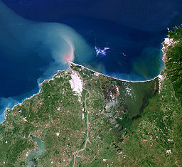
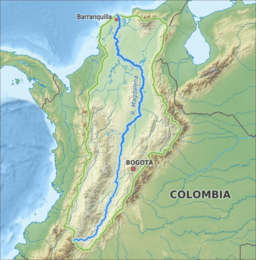
Magdalena River The delta of the Magdalena RiverName origin: Biblical figure Mary Magdalene Country Colombia Tributaries - left Páez River, Saldaña River, La Miel River, Nare River, Cauca River, San Jorge River - right Cabrera River, Bogotá River, Negro River, Carare River, Sogamoso River, Cesar River Cities Neiva, Girardot, Honda, La Dorada, Puerto Boyacá, Puerto Berrío, Barrancabermeja, Santa Cruz de Mompox, Barranquilla Source La Magdalena lagoon [1] - location Colombian Massif, Colombia - elevation 3,685 m (12,090 ft) - coordinates 1°56′3″N 76°36′29″W / 1.93417°N 76.60806°W Mouth Caribbean Sea - location Baranquilla, Colombia - elevation 0 m (0 ft) - coordinates 11°7′0″N 74°51′0″W / 11.116667°N 74.85°W Length 1,528 km (949 mi) [2] Basin 257,438 km2 (99,397 sq mi) Discharge for Calamar, Bolívar - average 7,200 m3/s (254,300 cu ft/s) [3] - max 12,000 m3/s (423,800 cu ft/s) - min 2,000 m3/s (70,600 cu ft/s) The Magdalena River (Spanish: Río Magdalena)[4] is the principal river of Colombia, flowing northward about 1,528 kilometres (949 mi) through the western half of the country. It takes its name from the biblical figure Mary Magdalene. It is navigable through much of its lower reaches, in spite of the shifting sand bars at the mouth of its delta, as far as Honda, at the downstream base of its rapids. It flows through the Magdalena River Valley.
Its drainage basin covers a surface of 27.3 million hectares, which is 24% of the country's area and where 66% of its population lives. Also 86% of Colombia's gross domestic product is generated there.[5]
Contents
Course
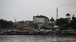
 Looking up towards Barrancabermeja, Colombia from the Magdalena River. In the foreground are the docks for motor canoes and small boats. The dome in the center of the skyline is the city's cathedral and the flame in the background is from the oil refinery.
Its headwaters are in the south of the country, where the Andean subranges Cordillera Central and Cordillera Oriental separate, in Huila Department. The river then runs east of north in a great valley between the two cordilleras. It reaches the coastal plain at about nine degrees north, then runs west for about 100 kilometres, then north again, reaching the Caribbean Sea at the city of Barranquilla in the zone known as Bocas de Ceniza.
Biology
The Magdalena River crosses a wide variety of ecosystems, like páramo in its headwaters, dry forest in the upper part of its valley, rain forest in its middle course, and swamps and wetlands in its lower course.[6] The Spectacled Caiman, iguana, pelican and catfish are abundant in these ecosystems but other animal species like the Prochilodus magdalenae, crocodile and red-footed tortoise are in critical danger of extinction.[7] In addition, there is a possible risk posed by invasive hippopotamus. Originally imported by Pablo Escobar, these hippopotami became feral following his demise, and have since expanded beyond their original home on Hacienda Napoles into nearby regions of the Magdalena River.
History
Due to its geographical position in the north of South America, the Magdalena River was since precolumbian times a route towards the interior of today Colombia and Ecuador. The Carib people probably ascended trough the river, as well as other cultures from Mesoamerica.
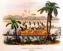
Likewise, the Spanish conquistadores who arrived to today's Colombia early in the 16th century used the river to push to the wild and mountainous inland after Rodrigo de Bastidas discovered and named the river on April 1, 1501. During the Spanish colonization of the Americas, the river was the only transport link communicating Bogotá with the Caribbean Sea port Cartagena de Indias and thus with Europe.
In 1825, the Congress of Colombia awarded a concession to establish steam navigation in the Magdalena River to Juan Bernardo Elbers,[8] but his company closed shortly after. By 1845, steamboats regularly travelled on the river[9] until 1961, when the last steamers ceased operation.[8]
Gallery
-
Honda city upon Magdalena River
-
Puerto Boyacá port in middle Magdalena region
-
Magdalena river near Barranquilla
In mass media
Much of the film Love in the Time of Cholera takes place in the historic, walled city of Cartagena in Colombia. Some screen shots showed the Magdalena River and the Sierra Nevada de Santa Marta mountain range.
References
- ^ Restrepo, J.; Kjerfve, B.; Hermelin, M.; Restrepo, J. (2006). "Factors controlling sediment yield in a major South American drainage basin: The Magdalena River, Colombia". Journal of Hydrology 316: 213–232. doi:10.1016/j.jhydrol.2005.05.002.
- ^ "Sistema de informacion Ambiental de Colombia - SIAC" (in Spanish). http://www.siac.gov.co/contenido/contenido_imprimir.aspx?conID=413&catID=320. Retrieved 2011-07-13.
- ^ "Chapter 14" (PDF). The Pacific and Caribbean Rivers of Colombia: Water Discharge, Sediment Transport and Dissolved Loads. http://geotest.tamu.edu/userfiles/167/210.pdf. Retrieved 2011-07-13.
- ^ "Polinizaciones: Las Abejas y las Garzas / The Bees and Storks". Polinizaciones.blogspot.com. jueves 7 de febrero de 2008. http://polinizaciones.blogspot.com/2008/02/las-abejas-y-las-garzas-bees-and-storks.html. Retrieved 2008-11-06.
- ^ "NUESTRO RIO" (in Spanish). http://fs03eja1.cormagdalena.com.co/nuevaweb/conozcanos/rio.htm. Retrieved 2011-07-12.
- ^ "Magdalena Valley dry forests". http://www.eoearth.org/article/Magdalena_Valley_dry_forests. Retrieved 2011-07-15.
- ^ "CUIDEMOS NUESTRO RÍO MAGDALENA" (in Spanish) (PDF). http://fs03eja1.cormagdalena.com.co/nuevaweb/pagina%20ni%C3%B1os/CUIDEMOS%20NUESTRO%20RIO%20MAGDALENA.pdf. Retrieved 2011-07-15.
- ^ a b "Navegación a Vapor en Colombia | xcafe.co" (in Spanish). http://xcafe.co/blog/2010/05/26/navegacion-a-vapor-en-colombia/. Retrieved 2011-07-15.
- ^ Alfred Hettner. "En el río Magdalena." (in Spanish). Viajes por los Andes colombianos: (1882-1884). http://www.banrepcultural.org/blaavirtual/historia/viaand/viaand6.htm. Retrieved 2011-07-15.
Categories:- Rivers of Colombia
- Populated places on the Magdalena River
-
Wikimedia Foundation. 2010.


