- Meta Department
-
Department of Meta
Departamento del Meta— Department — 
Flag
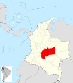
Coat of armsMotto: Llano Grande de Colombia y Meta Anthem: Himno de Meta (Colombia) Meta shown in red Coordinates: 4°9′N 73°38′W / 4.15°N 73.633°WCoordinates: 4°9′N 73°38′W / 4.15°N 73.633°W Country  Colombia
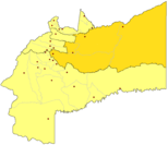
Region Orinoquía Region Established July 1, 1960 Capital Villavicencio Government – Governor Dario Vásquez Sánchez (2008-) Area – Total 85,635 km2 (33,063.9 sq mi) Area rank 4 Population (2005)[1] – Total 789,276 – Rank 19 – Density 9.2/km2 (23.9/sq mi) Time zone UTC-05 ISO 3166 code CO-MET Provinces 4 Municipalities 29 Website www.meta.gov.co Meta is a department of Colombia. It is close to the geographic center of the country, to the east of the Andean mountains. A large portion of the department, which is also crossed by the Meta River, is covered by a grassland plain known as the Llanos. Its capital is Villavicencio. The department has a monument placed in the very geographic centre of Colombia.
Achagua, which is similar to Piapoco, is an Indigenous language spoken by a minority in the department.
Contents
Municipalities
Ariari Villavicencio Piedemonte Meta River El Castillo • El Dorado • Fuente de Oro • Granada • La Uribe • Lejanías • Mapiripán • Mesetas • Puerto Concordia • Puerto Lleras • Puerto Rico • San Juan de Arama • Vista Hermosa Villavicencio Acacías • Barranca de Upía • Castilla la Nueva • Cubarral • Cumaral • El Calvario • Guamal • Restrepo • San Carlos de Guaroa • San Juanito • San Martín Cabuyaro • La Macarena • Puerto Gaitán • Puerto López References
External links
- Folklore llanero
- Government Meta
- Territorial-Environmental Information System of Colombian Amazon SIAT-AC website (Spanish)
See also
- San Martín Territory
Departments of Colombia  Categories:
- Orinoquía Region geography stubs
- Meta Department
- States and territories established in 1960
- Departments of Colombia
Wikimedia Foundation. 2010.

