- Cumaral
-
Cumaral — Municipality and town — 
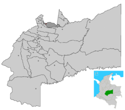
SealLocation of the municipality and town of Cumaral in the Meta Department. Coordinates: 4°15′N 73°20′W / 4.25°N 73.333°WCoordinates: 4°15′N 73°20′W / 4.25°N 73.333°W Country Colombia Department Meta Department First settled July 3, 1901 Named for Cumare palm Government - Alcalde Luis Henry Navarrete (2008-2011) Area - Total 580 km2 (223.9 sq mi) Elevation 452 m (1,483 ft) Population [1] - Total 16,634 Time zone Colombia Standard Time (UTC-5) Website Official Website of Cumaral Cumaral is a town and municipality in the Meta Department, Colombia.
References
Municipalities in Meta Department Acacías • Barranca de Upía • Cabuyaro • Castilla la Nueva • Cubarral • Cumaral • El Calvario • El Castillo • El Dorado • Fuente de Oro • Granada • Guamal • La Macarena • La Uribe • Lejanías • Mapiripán • Mesetas • Puerto Concordia • Puerto Gaitán • Puerto Lleras • Puerto López • Puerto Rico • Restrepo • San Carlos Guaroa • San Juan de Arama • San Juanito • San Martín • Villavicencio • Vista HermosaCategories:- Populated places in the Meta Department
- Municipalities of Meta
- Orinoquía Region geography stubs
Wikimedia Foundation. 2010.

