- Aguachica
Infobox City
official_name = Aguachica
nickname =
motto =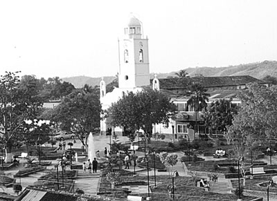
imagesize = 200px
image_caption = The San Roque Park in "Aguachica.
image_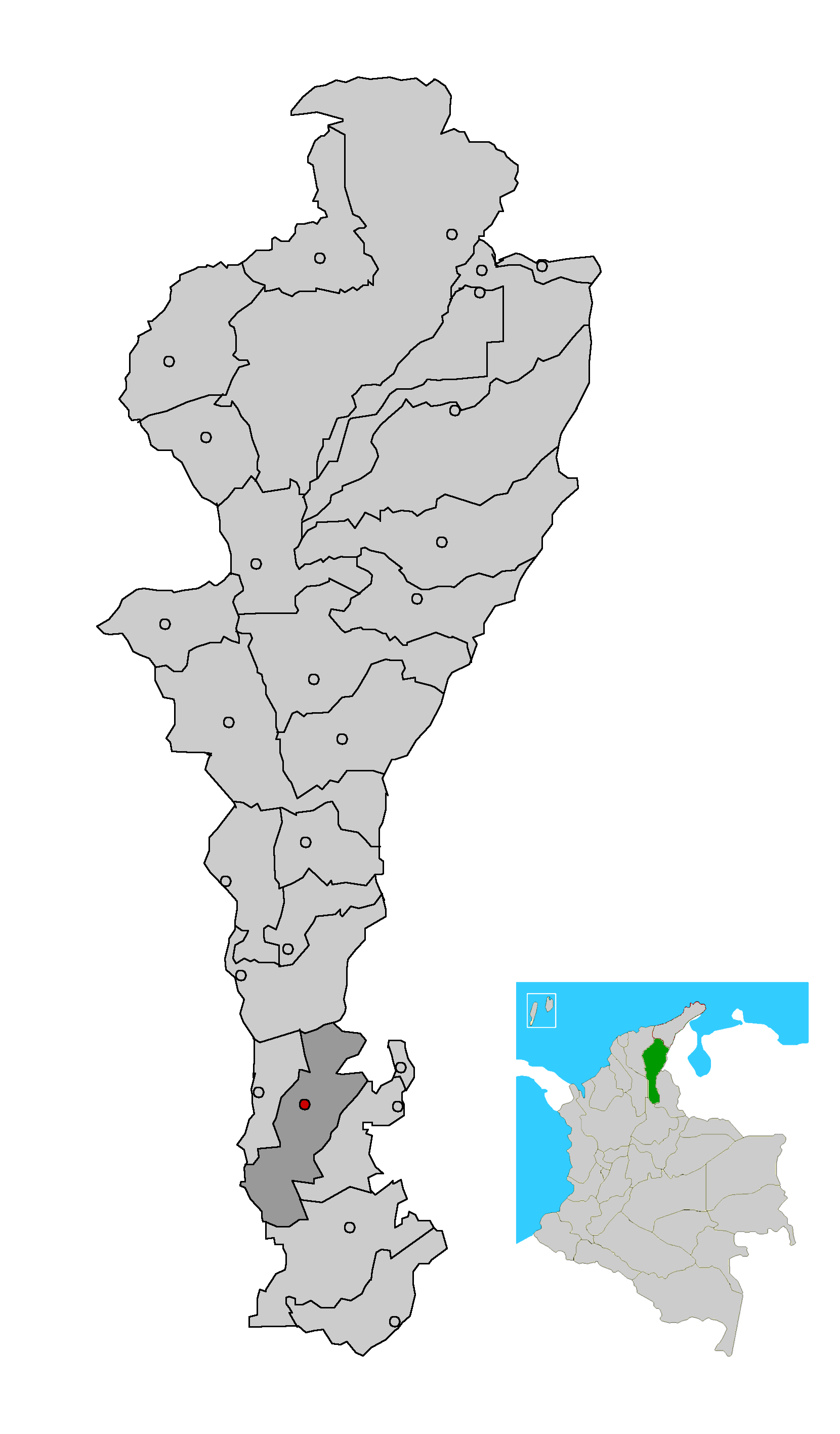
mapsize = 200px
map_caption = Location in the Department of Cesar. Municipality (dark gray), City (red).
subdivision_type =Country
subdivision_type1 = Region
subdivision_type2 = Department
subdivision_name =Colombia
subdivision_name1 = Caribbean
subdivision_name2 = Cesar
leader_title = Mayor
leader_name =Gustavo Adolfo Maldonado
(Colombia Democrática ) [ [http://www.elpilon.com.co/noticias/not00006609.htm es icon El Pilon: Con cero abstención: Un bumangués, nuevo alcalde de Aguachica] ]
established_title = Foundation
established_date =August 16 ,1748
area_magnitude =
area_total_sq_mi =
area_total_km2 = 876.26
area_land_sq_mi =
area_land_km2 =
area_water_sq_mi =
area_water_km2 =
area_water_percent =
area_urban_sq_mi =
area_urban_km2 =
area_metro_sq_mi =
area_metro_km2 =
population_as_of = 2005
population_note = [ [http://www.colombiassh.org/site/IMG/png/demografia.pngColombiassh.org: Census 2005: Aguachica] ] [ [http://www.dane.gov.co/files/censo2005/regiones/cesar/aguachica.pdf es icon DANE 2005 Census: Aguachica] ]
population_total = 80789
population_metro =
population_urban =
population_density_km2 =
population_density_sq_mi =
timezone =
utc_offset = -5
timezone_DST =
utc_offset_DST =
latd= |latm= |lats= |latNS=
longd= |longm= |longs= |longEW=
elevation_m = 162
elevation_ft =
website =
[http://www.aguachica-cesar.gov.co/sitio.shtml www.aguachica-cesar.gov.co]
footnotes =Aguachica, is a small city and municipality in the southern region of the
Department of Cesar ,Colombia . It was officially founded inAugust 16 ,1748 by José Lázaro de Rivera.Geography
The municipality is located south of the
Department of Cesar , between the Cordillera Oriental Andean mountains and theMagdalena River . The municipality of Aguachica borders to the north with the municipality ofLa Gloria and theDepartment of North Santander (municipality of El Carmen); to the east with the municipality of Rio de Oro; to the south with Rio de Oro once again, with the municipality of San Martín and theDepartment of Santander (municipality ofPuerto Wilches ) and to the west with the municipality ofGamarra and theDepartment of Bolívar (municipality of Morales) covering a total area of 876 km², 3.8% of the total area of the Department of Cesar. [ [http://www.alcaldiadeaguachica.gov.co/generalidades/parte1.pdf Townhall of Aguachica: Generalities: Geography] ]The northern area of the municipality is mountainous part of the Cordillera Oriental mountain range with altitude variating between the 200 m and 2,150 m over sea level. The southern area of the municipality of Aguachica is predominantly flat with two major rivers flowing through the region; the
Magdalena River and theLebrija River . [ [http://www.alcaldiadeaguachica.gov.co/generalidades/parte1.pdf Townhall of Aguachica: Generalities: Geography] ]History
Pre-Columbian
The territory of present day Aguachica was inhabited by
amerindian Chimila tribes, before the Spanish conquerors arrived. This tribe was later brutally decimated by the Spanish.panish conquest and colonization
During the first decades of the 18th century, the area was established as the
Hacienda de San Roque by the Spanish and was owned by Don Antonio Garia de Bonilla, but due to pests and illnesses the settlement was moved a few hundred meters to the south. By 1722 the settlement had grown in the middle of an hacienda predominantly owned by Don Casimiro Ramos de Barahoja. The settlement was serving now as a rest area for merchants traveling to and from the nearby fluvial port town ofGamarra and Ocaña (present-dayDepartment of North Santander ). [ [http://www.alcaldiadeaguachica.gov.co/generalidades/parte1.pdf Townhall of Aguachica: Generalities: History] ]In
August 17 ,1748 the settlement was officially founded by Jose Lazaro de Rivera and established as a Roman Catholicparish . [ [http://www.alcaldiadeaguachica.gov.co/generalidades/parte1.pdf Townhall of Aguachica: Generalities: History] ] By this time the Spanish conquerorJose Fernando de Mier y Guerra was ordered to "pacify" theChimilas indigenous groups and to reorganize some villages in the basin of the Magdalena river. These foundations and re-foundations were approved back then byJosé Alfonso Pizarro viceroy of theViceroyalty of New Granada between 1749 and 1753. In 1753 the Spanish ordered the construction of houses in Aguachica and was made part of the Government of Santa Marta. [ [http://www.alcaldiadeaguachica.gov.co/generalidades/parte1.pdf Townhall of Aguachica: Generalities: History] ]Between 1798 and 1804 a plague swept most of the population causing the village to move to its present location. In 1914 became a municipality. [es icon Cesar 30 Años de Progreso - Gobernación del Cesar (1997). -Page 19-] ]
Republicanism
By 1850 the first migrants arrived to Aguachica largely attracted by the plantations of
coffee in neighboring Ocaña,Sovereign State of Santander and also introduced agricultural and farming practices for commerce in the region. During the 1920s,Petroleum deposits were found in the area triggering another wave of migrants mostly from the neighboring departments of Colombia; Antioquia, Caldas, Santander, North Santander and Boyaca. [ [http://www.alcaldiadeaguachica.gov.co/generalidades/parte1.pdf Townhall of Aguachica: Generalities: History] ]During the 1950s the construction of the highway and the Magdalena railroad turned Aguachica into a strategic area between the Andean region and Caribbean region. [ [http://www.alcaldiadeaguachica.gov.co/generalidades/parte1.pdf Townhall of Aguachica: Generalities: History] ] The 1960s were marked by the migration of people from the
Department of Tolima mostly farmers interested on exploiting the land, developing large plantations ofcotton ,sorghum ,rice , among other products. The economy grew, developing an economy based on agricultural products, commerce and services. [ [http://www.alcaldiadeaguachica.gov.co/generalidades/parte1.pdf Townhall of Aguachica: Generalities: History] ]Colombian armed conflict
During the 1980s and early 1990s the region was influenced by the
Colombian armed conflict producing the displacement of people from the countryside and from neighboring regions of the southernDepartment of Bolívar and the Department of Cesar into the municipality seat. [ [http://www.alcaldiadeaguachica.gov.co/generalidades/parte1.pdf Townhall of Aguachica: Generalities: History] ]Politics
Administrative divisions
The municipality of Aguachica is subdivided into 22 Corregimientos:
Corregimientos
*Barranca Lebrija
*Boqueron
*Buturama
*Cerro Bravo
*Cerro Redondo
*Cuatro Rocas
*El Juncal
*La Morena
*Las Adjuntas
*Lucaical
*Norean
*San Miguel
*Santa Lucia
*Villa Nueva
*La Campana
*Las Juntas
*La Yegüera
*Loma de Corredor
*Mucuras
*Patiño
*Pitalimon
*Puerto Amalia
*San Andres de Totumal
*San Francisco
*Santa Barbara
*Santa Rosa
*Soledad
*Torcoroma
*Villa de San Andres
*VillanuevaVeredas
*Barcelona
*Bombadiero
*Cañada Ospina
*Caracol
*Costa Rica
*El Corral
*El Tope
*Esmeralda Alta
*Honduras
*Cascabela
*La Pajuila
*La Ye
*Las Bateas
*Bella Vista
*Capoalegre
*Caño Caracoli
*Cerro de los Bustos
*El Carbon
*El Faro
*Esmeralda
*Guaduas
*La Bocatoma
*La Ceiba
*La Union
*La Yeguerita
*Las LatasDemographics
In the 2005 Cesus by the DANE the municipality of Aguachica had a total population of 80,789. [ [http://www.dane.gov.co/files/censo2005/regiones/cesar/aguachica.pdf es icon DANE 2005 Census: Aguachica] ]
The majority of the population 51% is female while 49% are male. Of these 0.1% considered itself of indigenous ancestry and 3.7% of
Afro-Colombian ancestry. [ [http://www.dane.gov.co/files/censo2005/perfiles/cesar/aguachica.pdf es icon 2005 DANE Census: Demographic statistics Municipality of Aguachica] ]87% of these 80,789 people living in houses, while 2.1% lived in apartment buildings and 10% in rented rooms. 4.8% of these homes were also used for home businesses. 90% of the municipality of Aguachica had electricity, 73% with sewage service, 87% had aqueduct services, 50% had natural gas services installed at home while 30% percent had a telephone line. [ [http://www.dane.gov.co/files/censo2005/perfiles/cesar/aguachica.pdf es icon 2005 DANE Census: Demographic statistics Municipality of Aguachica] ]
References
External links
*es icon [http://www.aguachica-cesar.gov.co/sitio.shtml Aguachica official website]
*es icon [http://www.dane.gov.co/files/censo2005/perfiles/cesar/aguachica.pdf 2005 Census: Aguachica]
*es icon [http://www.lablaa.org/blaavirtual/publicacionesbanrep/boletin/boleti5/bol27/agua.htm Luis Angel Arango Library: Aguachica y algodón: historias paralelas]
Wikimedia Foundation. 2010.