- Piscataway Park
-
Piscataway Park IUCN Category V (Protected Landscape/Seascape)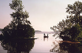
View of the Potomac River at Piscataway Park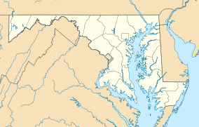

Location Prince George's County, Maryland, USA Nearest city Accokeek, MD Coordinates 38°40′43″N 77°05′34″W / 38.67861°N 77.09278°WCoordinates: 38°40′43″N 77°05′34″W / 38.67861°N 77.09278°W Established October 4, 1961 [1] Visitors 176,174 (in 2005) Governing body National Park Service Piscataway Park, located 20 miles (32 km) southwest of downtown Washington, D.C., near Accokeek, Maryland, protects Marshall Hall and the National Colonial Farm. The park is located across the Potomac River from George Washington's Mount Vernon estate.
Piscataway Park is named after Piscataway Creek, itself named for a historic Native American tribe. The park is home to bald eagles, beavers, osprey, and other wildlife[1] and encompasses areas of wetland, meadow and woodland. It is administered by the National Park Service and is managed by National Capital Parks-East.[2]
Contents
History
Henry and Alice Ferguson bought more than 100 acres (0.40 km2) of land in the area in 1928. It includes the area of Moyaone, a Native American Piscataway village last occupied in 1623. The Fergusons bought more property and encouraged friends to settle nearby, where they could protect the environment. After Alice's death in 1951, Ferguson created the Alice Ferguson Foundation, which administered the land. The foundation made arrangements to donate property to the National Park Service for parkland, a transaction completed in the 1960s.[3] This both protected the environment, as well as the "historic viewshed" as seen from the Mount Vernon mansion, keeping the parkland as it was in George Washington's day, and preventing modern development along the shore of the river.
National Colonial Farm
See also: Claude Moore Colonial FarmThe National Colonial Farm is a living history example of a 1770s tobacco farm typical of a common planter. Many of the structures on the site are open to visitors, including a barn, smokehouse, out-kitchen, and the farm house. Costumed interpreters demonstrate various techniques, including candlemaking, gardening, and sewing.
References
- ^ "Piscataway Park". Accokeek Foundation. http://www.accokeek.org/visit/piscatway_park.
- ^ "Piscataway Park". National Park Service. http://www.nps.gov/pisc/index.htm. Retrieved June 2, 2011.
- ^ Ann Cameron Siegal, "Quietly Tucked In Near the Potomac: Moyaone Residents Keep Close to Nature", The Washington Post, 23 Jul 2010
External links
- National Park Service Piscataway Park official website
- "Piscataway Park" – Chesapeake Bay Gateways Network
Protected Areas of Maryland Federal Catoctin Mountain Park • Fort Foote Park • Fort Washington Park • Glen Echo Park • Greenbelt Park • Harmony Hall • Oxon Cove Park and Oxon Hill Farm • Piscataway Park
Blackwater • Eastern Neck • Martin • Patuxent Research Refuge • Susquehanna RiverState Assateague • Big Run • Bill Burton Fishing Pier State Park • Calvert Cliffs • Casselman River Bridge • Chapel Point • Cunningham Falls • Dans Mountain • Deep Creek Lake • Elk Neck • Fort Frederick • Fort Tonoloway • Gambrill • Gathland • Greenbrier • Greenwell • Gunpowder Falls • Hart-Miller Island • Herrington Manor • Janes Island • Jonas Green • Martinak • Matapeake • New Germany • North Point • Palmer • Patapsco Valley • Patuxent River • Pocomoke River • Point Lookout • Purse • Rocks • Rocky Gap • Rosaryville • Sandy Point • Seneca Creek • Smallwood • South Mountain • St. Clement's Island • St. Mary's River • Susquehanna • Swallow Falls • Tuckahoe • Washington Monument • Wye Oak
Cedarville • Chesapeake • Doncaster • Elk Neck • Garrett • Green Ridge • Pocomoke • Potomac-Garrett • Savage River • Seth • Stoney • Wicomico
Avondale • Belle Grove • Billmeyer • Bowen • Cedar Island • Cedar Point • Cheltenham • Chicamuxen • Dan's Mountain • Deal Island • Diersson • E.A. Vaughn • Earlville • Ellis Bay • Fairmount • Fishing Bay • Frederick City Watershed • Grove Farm • Gwynnbrook • Heater's Island • Hugg-Thomas • Idylwild • Indian Springs • Islands of the Potomac • Isle of Wight • Johnson • Le Compte • Linkwood • McKee-Beshers • Maryland Marine Properties • Millington • Mt. Nebo • Myrtle Grove • Nanticoke River • Old Bohemia • Pocomoke River • Prather’s Neck • Pocomoke Sound • Sideling Hill • Sinepuxent Bay • South Marsh • Strider • Taylors Island • Warrior Mountain • Wellington
Belt Woods • Dundee • Governor Parris N. Glendening • Mattawoman • Morgan Run • Severn Run • Soldiers Delight • Zekiah Swamp
County and
MunicipalParks & SanctuariesAcorn Park • Clifton Park • Constitution Park • Fort Smallwood Park • Jug Bay Wetlands Sanctuary • Lake Centennial • Lake Elkhorn • Lakelands Park • Oregon Ridge Park • Patterson Park • Robert E. Lee Memorial ParkNon-governmental Parks & SanctuariesBattle Creek Cypress Swamp Sanctuary • Merkle Wildlife Sanctuary • Sherwood Gardens • Somers Cove Marina • Sugarloaf Mountain • Western Maryland Rail Trail • Youghiogheny Scenic & Wild River
Maryland Department of Natural Resources (web): Maryland Park Service (web) and Maryland Forest ServiceU.S. National Register of Historic Places Topics Lists by states Alabama • Alaska • Arizona • Arkansas • California • Colorado • Connecticut • Delaware • Florida • Georgia • Hawaii • Idaho • Illinois • Indiana • Iowa • Kansas • Kentucky • Louisiana • Maine • Maryland • Massachusetts • Michigan • Minnesota • Mississippi • Missouri • Montana • Nebraska • Nevada • New Hampshire • New Jersey • New Mexico • New York • North Carolina • North Dakota • Ohio • Oklahoma • Oregon • Pennsylvania • Rhode Island • South Carolina • South Dakota • Tennessee • Texas • Utah • Vermont • Virginia • Washington • West Virginia • Wisconsin • WyomingLists by territories Lists by associated states Other Categories:- IUCN Category V
- Museums in Prince George's County, Maryland
- National Register of Historic Places in Maryland
- Parks in Prince George's County, Maryland
- United States National Park Service areas in Maryland
- National Capital Parks-East
- United States National Park Service stubs


Wikimedia Foundation. 2010.