- Cizre
-
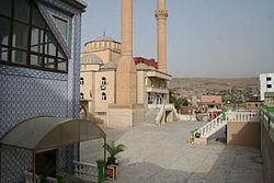
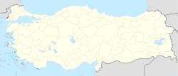
Cizre Noah's Mausoleum in Cizre Location of Cizre in Turkey Coordinates: 37°19′30″N 42°11′45″E / 37.325°N 42.19583°ECoordinates: 37°19′30″N 42°11′45″E / 37.325°N 42.19583°E Country  Turkey
Region Southeastern Anatolia Province Şırnak Government – Mayor Aydin Budak (Peace and Democracy Party) Area – City 460 km2 (177.6 sq mi) Population (2000) – Urban 94,835 Time zone EET (UTC+2) – Summer (DST) EEST (UTC+3) Postal code 73xxx Area code(s) +(90)486 Website [1] Cizre (pronounced [dʒizˈɾe]; Kurdish: Botan, Syriac: ܓܙܝܼܪܵܐ Gzira/Gziro) is a town and district of Şırnak Province in the Southeastern Anatolia Region of Turkey, located at the border to Syria, just to the north-west of the Turkish-Syrian-Iraqi tripoint. It is populated by a majority of Kurds and Assyrian/Syriac people in addition to Arabs. It is surrounded by the Tigris from the North, East and South, which has given it its name, which means island in Arabic.
Contents
History
Cizre is historical Jazīrat ibn ʿUmar (or Jezira ibn Umar or Gazarta) Arabic: جزيرة ابن عمر, an important town during the Abbasid period and the Crusades as a gateway connecting Upper Mesopotamia to Armenia. During the Early Iron Age, Cizre was in the kingdom of Kumme, north of Assyria. In classical antiquity, it was located in Corduene (Kardu). In 19th century scholarship, it was often named as the location of Alexander's crossing of the Tigris in 331 BC, further identified with the Roman stronghold of Bezabde although Stein (1942) is sceptical of this.
In medieval Islamic tradition, it is the location of Thamanin, the town founded by Noah at the foot of Mount Judi where the Ark came to rest, and a "tomb of Noah" as well as a "tomb of Mem and Zin" can be visited in Cizre. Al-Masudi (d. 956) reports that the spot where the ark landed could still be seen in his time. Benjamin of Tudela in the 12th century adds that ʿUmar ibn al-Khaṭṭāb had made the remnants of the ark into a mosque.
Cizre was the seat of the East Syrian bishops of Beth Zabdaï (later Gazarta d'Beth Zabdaï) as early as the fourth century, and the seat of the Chaldean bishops of Gazarta in the nineteenth and early twentieth centuries. The East Syrian population of the Gazarta region was severely reduced in the 1915 Seyfo massacres, and the Chaldean diocese of Gazarta lapsed after the First World War.
Cizre today
Cizre is located on the River Tigris, which forms the border line with Syria at this area. The state roads Midyat) and D.400 (European route E90) (via Nusaybin) that connect Mardin with Şırnak, as well as the route Silopi run through the town.
The border checkpoint in Cizre, the gate to Malikiye in Syria, was in use between 1940-1972.[1]
Cizre, with +48.6°C (119.5°F) on July 30, 2000, holds the record for the highest temperature ever recorded in Turkey.
Government
The mayor of Cizre, Aydin Budak, was arrested in December 2009 as part of the KCK investigation. In October 2011 he was removed from office by the Ministry of the Interior before his trial had concluded. [2]
References
- ^ "Letter to the Minister of Foreign Affairs" (in Turkish). Cizre Ticaret ve Sanayi Odası. November 29, 2005. http://www.cizretso.org/default.asp?goster=50&Sayfa=148. Retrieved March 15, 2009.
- ^ "Ministry of Interior, the PKK's hidden structure of the city of KCK / TM to begin operations on September 21, was arrested in Sirnak". Haber Monitor. 2011-10-15. http://www.habermonitor.com/en/haber/detay/60241/ministry-of-interior-the-pkk39s-hidden-struct. Retrieved 2011-10-23.
- J. Obermeyer, Die Landschaft Babylonien (1929)
- A. Ben-Jacob, Kehillot Yehudei Kurdistan (1961), 22, 24–25, 30.
- Encyclopaedia Judaica (2008)
- Aurel Stein, Notes on Alexander's Crossing of the Tigris and the Battle of Arbela, 1942, The Royal Geographical Society.
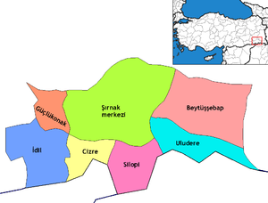
 Cizre in Şırnak Province (in the Southeastern Anatolia region) of Turkey
Urban districts 
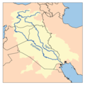
Rural districts RegionsAegean Black Sea Central Anatolia Eastern Anatolia Marmara Mediterranean Southeastern Anatolia The Tigris Countries 
Cities Tributaries Ambar · Kuru · Pamuk · Hazro · Batman · Garzan · Göksu · Savur · Botan · Little Khabur · Great Zab · Little Zab · ‛Adhaim · DiyalaList of crossings Land border crossings of Turkey
Bulgaria 
Greece 
Syria 
Iraq  Habur (Şırnak)
Iran 
Nakhchivan (Azerbaijan)  Umut (Iğdır)
Armenia  Akyaka (Kars)
Georgia  Categories:
- Districts of Şırnak
- Southeastern Anatolia Region
- Assyrian settlements
- Syria–Turkey border crossings
- Populated places in Şırnak Province
- Kurdistan
- Noah's Ark
Wikimedia Foundation. 2010.


