- Ordu Province
-
Ordu Province
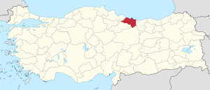
Ordu ili— Province of Turkey — Location of Ordu Province in Turkey Country Turkey Region Black Sea Capital Ordu Area - Total 6,001 km2 (2,317 sq mi) Population (2010-12-31)[1] - Total 719,183 - Density 119.8/km2 (310.4/sq mi) Area code(s) 0452 Vehicle registration 52 Website ordu.gov.tr Ordu Province (Turkish: Ordu ili ) is a province of Turkey, located on the Black Sea coast. Its adjacent provinces are Samsun to the northwest, Tokat to the southwest, Sivas to the south, and Giresun to the east. Its traffic code is 52. The capital of the province is the city of Ordu.
Contents
Etymology
"Ordu" means 'army' in Turkish but there are many speculations about the name's meaning.
Geography
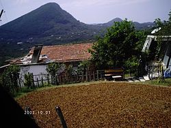
Ordu is a strip of Black Sea coast and the hills behind, historically an agricultural and fishing area and in recent years, tourism has seen an increase, mainly visitors from Russia and Georgia, as Ordu boasts some of the best beaches, rivers, and lush, green mountains on the Black Sea coast. Walking in the high pastures is now a popular excusrion for Turkish holidaymakers.
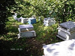
Ordu is famous for hazelnuts. Turkey as a whole produces about 70 percent of the world's hazelnuts, and over 50 percent of those come from Ordu.[2] The recent drop in hazelnut prices however have led farmers to supplement their income with honeybees. The higher altitudes are covered in forest. Melet river, Bolaman river, Fatsa river, Cevizdere stream, Curi stream and Bağdere stream are main rivers of the Ordu province and Gaga lake is the only lake of the city [3]
Mostly Chepni Turks and other Oghuz Turks live here and the province is home to a minority of Cheveneburi Georgians [4] and Muslims of Greek ethnic origin in Mesudiye.
In recent decades many people from Ordu have migrated away to jobs in Istanbul, Bursa, Samsun, Sakarya or abroad.
Districts
Ordu province is divided into 19 districts (capital district in bold):
Places to see
Ordu has an attractive coast including pretty bays and the cleanest and longest beaches on this stretch of the Black Sea coast. Specific sites include:
- The Russian bazaar in the city of Ordu
- Boztepe - a 460 m hill above the city.
- Karagöl - a crater lake at 3107 m, above the plateau of Çambaşı
- Yason (Jason) point - a headland in Perşembe
- Çambaşı Yaylası a high plateau
- Meletios Greek Church in Mesudiye
- Samuga Armenian Church in Mesudiye
Well-known residents
- Fikri Sönmez - left-wing mayor of Fatsa in the period leading up to the 1980 Turkish coup d'état
University
- Ordu University[5]
References
- ^ Turkish Statistical Institute, MS Excel document – Population of province/district centers and towns/villages and population growth rate by provinces
- ^ Inventory Of Hazelnut Research, Germplasm And References
- ^ Ordu
- ^ Chveneburi.Net :: Yeni Sayaca Köyü - Ulubey - Ordu
- ^ http://odu.edu.tr/tr/]
External links
- (English) Ordu governor's official website
- (Turkish) Ordu municipality's official website
- (English) Ordu weather forecast information
- (Turkish) Ordum.com local information
Urban districts 
Rural districts RegionsAegean Black Sea Central Anatolia Eastern Anatolia Marmara Mediterranean Southeastern Anatolia  Provinces of Turkey
Adana · Adıyaman · Afyonkarahisar · Ağrı · Aksaray · Amasya · Ankara · Antalya · Ardahan · Artvin · Aydın · Balıkesir · Bartın · Batman · Bayburt · Bilecik · Bingöl · Bitlis · Bolu · Burdur · Bursa · Çanakkale · Çankırı · Çorum · Denizli · Diyarbakır · Düzce · Edirne · Elazığ · Erzincan · Erzurum · Eskişehir · Gaziantep · Giresun · Gümüşhane · Hakkâri · Hatay · Iğdır · Isparta · Istanbul · İzmir · Kahramanmaraş · Karabük · Karaman · Kars · Kastamonu · Kayseri · Kilis · Kırıkkale · Kırklareli · Kırşehir · Kocaeli · Konya · Kütahya · Malatya · Manisa · Mardin · Mersin · Muğla · Muş · Nevşehir · Niğde · Ordu · Osmaniye · Rize · Sakarya · Samsun · Şanlıurfa · Siirt · Sinop · Şırnak · Sivas · Tekirdağ · Tokat · Trabzon · Tunceli · Uşak · Van · Yalova · Yozgat · Zonguldak

Coordinates: 40°48′41″N 37°32′26″E / 40.81139°N 37.54056°E
Categories:
Wikimedia Foundation. 2010.


