- Fatsa
Infobox Settlement
settlement_type = Town
subdivision_type = Country
subdivision_name = TUR
timezone=EET
utc_offset=+2
map_caption =Location of PAGENAME within Turkey.
timezone_DST=EEST
utc_offset_DST=+3official_name = Fatsa
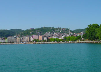
image_caption = A panoramic view of the town
image_blank_emblem =
blank_emblem_type =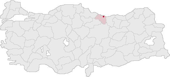
subdivision_type1=Region
subdivision_name1 = Black Sea
subdivision_type2=Province
subdivision_name2 = Ordu| population_total = 120774|population_footnotes=
population_as_of =| 2003
population_footnotes =
population_density_km2 =
area_total_km2 = 570|elevation_m = 57- 550
pushpin_
pushpin_label_position =
pushpin_map_caption =Location of Fatsa
pushpin_mapsize =
latd = 41
latm = 02
latNS = N
longd = 37
longm = 30
longEW = E
postal_code_type=Postal code
postal_code = 52
area_code = 0452
blank_info = 52|blank_name=Licence plate
leader_name =
website = http://www.fatsa.gov.trFatsa is a town and a large district of
Ordu Province in the central Black Sea region ofTurkey .Etymology
The name Fatsa derives from "Fanizan" daughter of King
Pharnaces II of Pontus and has since mutated through "Fanise", "Phadsane", "Pytane", "Facha" and today's "Fatsa". In theOttoman Empire records the town as its name "Satılmış". The Greeks called it also "Polemonion" and "Side".Geography
The district is a strip of coastline with hills and rocky mountains rising steeply behind, watered by the rivers of "Yapraklı" and "Belice". The Canik Mountains run parallel to the coast behind Fatsa. The local economy depends on agriculture and fishing: 80% of arable land is planted with hazelnuts (see
Corylus avellana ) and there are fishing fleets harboured at Fatsa and in the small towns of "Yalıköy" and "Bolaman". Also the Black Sea coastal highway runs through here bringing passing trade. The higher mountain areas of the district are covered in forest. The climate is typical of theBlack Sea coast, warm and wet most of the year.Fatsa itself is a large town of 63,721 people with a large central shopping district of streets, some pedestrianised, leading down to the seafront. The district of Bolaman was once the Roman town of Poleman and has the ruins of a castle and places to drink tea by the water.
Places of interest
The countryside and coast of Fatsa are pretty in spring and summer and a number of places attract visitors including:
* the mineral water springs of "Ilıca".
* ThePontus era monastery of Göreği, 5km west of Fatsa near the...
** Çıngırt rock and caves
* Gaga lake - 10km south-east of Fatsa
* The ruins ofBolaman Castle There is a summer festival in Fatsa of sports, a beauty contest etc.
History
The history of Fatsa goes back to antiquity, when the coast was settled by
Cimmerians ,Persian people andAncient Greek colonists in the centuries BC, followed byAlexander the Great and his successors. The town grew in importance under the Kingdom ofPontus , particularly during the reign of Pharnaces II the ally ofPompey againstJulius Caesar in the1st century BC , who built the city here. Following the demise of Pontus the area passed intoAncient Rome andByzantine Empire hands.Turkish people s came to the area in the 11th century following theBattle of Manzikert and the Black Sea coast was quickly conquered by theDanishmends emir "Sevli Bey", and settled by Turkish immigrants. In the 13th and 14th centuries Genoese traders established trading posts along the coast, Fatsa became one of the most important of these, and there is a stone warehouse on the shore built in this period. The Genoese presence in the Black Sea ended with the fall ofConstantinople but Fatsa later thrived again under the Hacı Emir OğullarıAnatolian Turkish Beyliks in the late 14th century and became part of theOttoman Empire in 1427.In the 19th century the population increased as
Armenia ns, Georgians andCaucasus Turks migrated to the coast to escape the wars betweenRussia and the Ottomans. The Greek Christian community remained and thrived as craftsmen and bureaucrats until thePopulation exchange between Greece and Turkey in 1923, when 770 families of Turks from Greece were settled in the town and villages of Fatsa. In this period the town remained a port and trading post, there was no coast road toÜnye orOrdu and the port thrived. Corn, rice and other grains were grown in the hinterland and from the 1920s onwards hazelnuts were planted, when rice growing ceased as the coastal swamps were dried up by irrigation works and the town grew.In the 1970s Fatsa municipality was controlled by the left wing mayor Fikri Sönmez and his Devrimci Yol organisation of local committees under the slogan "The red sun will rise in Fatsa". A major incident in this period was the kidnapping by the
THKO in 1972 of three British technicians from the radar station ın Ünye. This era ended when, upon the initiative of the MHP supporting provincial governor, the mayor and 300 others were arrested in the "Nokta Operasyonu" of July 1980, two months before the1980 Turkish coup d'état . ["Bir Yerel Yönetim Deneyi" byPertev Aksakal (Simge Yayınevi) 1989] Throughout this period Fatsa lost a significant number of its people as they migrated away to jobs in Turkey's larger cities or abroad, including a large proportion of the Turkish community inJapan .Today the municipality is controlled by the Islamist-leaning AKP.
Notable natives
* The legendary bandits
Hekimoğlu , murdered in 1910, andSoytaroğlu . Gang leaders during clashes between Turks and Georgians in the 19th century.
*Fikri Sönmez ("Fikri the tailor") - revolutionary left-wing mayor of Fatsa in the 1970s.
* Film actor and symbol ofmachismo Kadir İnanır (b Fatsa 1949 - )
* SingerMehmet Gümüş -
* SingerSoner Arıca (b Fatsa 1966 - )References
External links
* [http://www.fatsa.gov.tr/ District governor's official website] tr icon

Wikimedia Foundation. 2010.